
Maryland Route 388
Encyclopedia
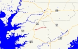
Maryland Route 388 is a state highway
in the U.S. state
of Maryland
. Known for most of its length as West Post Office Road, the state highway runs 2.38 miles (3.8 km) from MD 675
in Princess Anne
east to the end of state maintenance east of Princess Anne. MD 388 was constructed in the early 1930s.
's Delmarva Secondary track. The state highway's name changes to West Post Office Road after leaving the town limits of Princess Anne. After passing Freetown Road, MD 388 passes through a stretch of forest, where the highway meets the western end of Perryhawkin Road. After leaving the forest, the state highway reaches its eastern terminus when state maintenance ends at an arbitrary location between two farms. West Post Office Road continues east toward Meadow Bridge Road at the boundary between Somerset County
and Worcester County
just east of the historic post office
in the hamlet of West that gives the road its name.
.
{| class=wikitable
!Location
!Mile
!Destinations
!Notes
|-
|rowspan=2|Princess Anne
|rowspan=2|0.00
|Antioch Avenue west
|rowspan=2|Western terminus
|-
|
|-
|rowspan=2|
|1.68
|Perryhawkin Road east
|Former MD 696
|-
|2.38
|West Post Office Road east
|Eastern terminus
State highway
State highway, state road or state route can refer to one of three related concepts, two of them related to a state or provincial government in a country that is divided into states or provinces :#A...
in the U.S. state
U.S. state
A U.S. state is any one of the 50 federated states of the United States of America that share sovereignty with the federal government. Because of this shared sovereignty, an American is a citizen both of the federal entity and of his or her state of domicile. Four states use the official title of...
of Maryland
Maryland
Maryland is a U.S. state located in the Mid Atlantic region of the United States, bordering Virginia, West Virginia, and the District of Columbia to its south and west; Pennsylvania to its north; and Delaware to its east...
. Known for most of its length as West Post Office Road, the state highway runs 2.38 miles (3.8 km) from MD 675
Maryland Route 675
Maryland Route 675 is a collection of state highways in the U.S. state of Maryland. These two highways are sections of old alignment of U.S. Route 13 in Princess Anne in Somerset County and Delmar in northern Wicomico County. MD 675 was designated after US 13 bypassed Princess Anne in the late...
in Princess Anne
Princess Anne, Maryland
Princess Anne is a town in Somerset County, Maryland, United States. The population was 2,313 at the 2000 census. It is the county seat of Somerset County.Princess Anne is included in the Salisbury, Maryland Metropolitan Statistical Area....
east to the end of state maintenance east of Princess Anne. MD 388 was constructed in the early 1930s.
Route description
MD 388 begins as Antioch Avenue at an intersection with MD 675 (Somerset Avenue) in the center of Princess Anne. Antioch Avenue continues west two blocks as a municipal street. MD 388 heads east into farmland after crossing Norfolk Southern RailwayNorfolk Southern Railway
The Norfolk Southern Railway is a Class I railroad in the United States, owned by the Norfolk Southern Corporation. With headquarters in Norfolk, Virginia, the company operates 21,500 route miles in 22 eastern states, the District of Columbia and the province of Ontario, Canada...
's Delmarva Secondary track. The state highway's name changes to West Post Office Road after leaving the town limits of Princess Anne. After passing Freetown Road, MD 388 passes through a stretch of forest, where the highway meets the western end of Perryhawkin Road. After leaving the forest, the state highway reaches its eastern terminus when state maintenance ends at an arbitrary location between two farms. West Post Office Road continues east toward Meadow Bridge Road at the boundary between Somerset County
Somerset County, Maryland
-2010:Whereas according to the 2010 U.S. Census Bureau:*53.5% White*42.3% Black*0.3% Native American*0.7% Asian*0.0% Native Hawaiian or Pacific Islander*1.7% Two or more races*1.5% Other races*3.3% Hispanic or Latino -2000:...
and Worcester County
Worcester County, Maryland
-2010:Whereas according to the 2010 U.S. Census Bureau:*82.0% White*13.6% Black*0.3% Native American*1.1% Asian*0.0% Native Hawaiian or Pacific Islander*1.7% Two or more races*1.3% Other races*3.2% Hispanic or Latino -2000:...
just east of the historic post office
Post office
A post office is a facility forming part of a postal system for the posting, receipt, sorting, handling, transmission or delivery of mail.Post offices offer mail-related services such as post office boxes, postage and packaging supplies...
in the hamlet of West that gives the road its name.
History
Construction of MD 388 as a modern highway began in 1929 and was completed from Princess Anne east to Freetown Road in 1930. The remainder of the state highway was paved by 1933.Junction list
The entire route is in Somerset CountySomerset County, Maryland
-2010:Whereas according to the 2010 U.S. Census Bureau:*53.5% White*42.3% Black*0.3% Native American*0.7% Asian*0.0% Native Hawaiian or Pacific Islander*1.7% Two or more races*1.5% Other races*3.3% Hispanic or Latino -2000:...
.
{| class=wikitable
!Location
!Mile
!Destinations
!Notes
|-
|rowspan=2|Princess Anne
Princess Anne, Maryland
Princess Anne is a town in Somerset County, Maryland, United States. The population was 2,313 at the 2000 census. It is the county seat of Somerset County.Princess Anne is included in the Salisbury, Maryland Metropolitan Statistical Area....
|rowspan=2|0.00
|Antioch Avenue west
|rowspan=2|Western terminus
|-
|
|-
|rowspan=2|
|1.68
|Perryhawkin Road east
|Former MD 696
|-
|2.38
|West Post Office Road east
|Eastern terminus