
Maryland Route 376
Encyclopedia
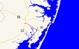
Maryland Route 376 is a state highway
in the U.S. state
of Maryland
. Known for most of its length as Assateague Road, the state highway runs 4.56 miles (7.3 km) from MD 818
in Berlin
east to MD 611
in Lewis Corner. MD 376 connects Berlin with communities on the Sinepuxent Neck and, in conjunction with MD 611, connects Berlin with Assateague Island National Seashore
. The state highway was constructed from Berlin in the second half of the 1920s and the early 1930s.
MD 377 (Williams Street), the state highway heads east as two-lane Bay Street east to U.S. Route 113
(Worcester Highway) and leaves the town of Berlin upon traversing Hudson Branch. The highway's name changes to Assateague Road and MD 376 continues southeast through farmland and forest, intersecting Sinepuxent Road after crossing Trappe Creek. The state highway spans Ayres Creek before reaching its eastern terminus at MD 611 (Stephen Decatur Highway) in Lewis Corner.
.
{| class=wikitable
!Location
!Mile
!Destinations
!Notes
|-
|rowspan=3|Berlin
|0.00
|
|Western terminus
|-
|0.01
|
|MD 377 is unsigned
|-
|0.42
|, Selbyville, DE
|
|-
|Lewis Corner
|4.56
|, Assateague Island National Seashore
|Eastern terminus
State highway
State highway, state road or state route can refer to one of three related concepts, two of them related to a state or provincial government in a country that is divided into states or provinces :#A...
in the U.S. state
U.S. state
A U.S. state is any one of the 50 federated states of the United States of America that share sovereignty with the federal government. Because of this shared sovereignty, an American is a citizen both of the federal entity and of his or her state of domicile. Four states use the official title of...
of Maryland
Maryland
Maryland is a U.S. state located in the Mid Atlantic region of the United States, bordering Virginia, West Virginia, and the District of Columbia to its south and west; Pennsylvania to its north; and Delaware to its east...
. Known for most of its length as Assateague Road, the state highway runs 4.56 miles (7.3 km) from MD 818
Maryland Route 818
Maryland Route 818 is a state highway in the U.S. state of Maryland. Known as Main Street, the state highway runs between two intersections with U.S. Route 113 on the north and south sides of Berlin in Worcester County. MD 818 is the original 1927 alignment of US 113 through Berlin...
in Berlin
Berlin, Maryland
Berlin is a town in Worcester County, Maryland, United States. The population was 3,491 at the 2000 census.-History:The town of Berlin had its start around the 1790s, part of the Burley Plantation, a land grant dating back to 1677...
east to MD 611
Maryland Route 611
Maryland Route 611 is a state highway in the U.S. state of Maryland. Known as Stephen Decatur Highway, the state highway runs from Assateague Island north to U.S. Route 50 in West Ocean City. MD 611 is named for Stephen Decatur, the U.S. naval officer of the early 19th century who was born in...
in Lewis Corner. MD 376 connects Berlin with communities on the Sinepuxent Neck and, in conjunction with MD 611, connects Berlin with Assateague Island National Seashore
Assateague Island National Seashore
Assateague Island National Seashore is a unit of the National Park Service occupying much of Assateague Island along the Atlantic coast of Maryland and Virginia. It is a barrier island shaped by stormy seas and gentle winds. It lies adjacent to Assateague State Park and Chincoteague National...
. The state highway was constructed from Berlin in the second half of the 1920s and the early 1930s.
Route description
MD 376 begins at an intersection with MD 818 (Main Street) in Berlin. After intersecting the southern end of unsignedUnsigned highway
An unsigned highway is a highway that has been assigned a route number, but does not bear conventional road markings that would normally be used to identify the route with that number...
MD 377 (Williams Street), the state highway heads east as two-lane Bay Street east to U.S. Route 113
U.S. Route 113
U.S. Route 113 is a spur of US 13 in the U.S. states of Maryland and Delaware. The U.S. Highway runs from US 13 in Pocomoke City, Maryland north to Delaware Route 1 in Milford, Delaware...
(Worcester Highway) and leaves the town of Berlin upon traversing Hudson Branch. The highway's name changes to Assateague Road and MD 376 continues southeast through farmland and forest, intersecting Sinepuxent Road after crossing Trappe Creek. The state highway spans Ayres Creek before reaching its eastern terminus at MD 611 (Stephen Decatur Highway) in Lewis Corner.
History
MD 376 was paved from the Berlin town line to just east of Trappe Creek in 1924. Bay Street within Berlin was paved in 1925. By 1930, MD 376 had been completed east almost to Ayres Creek. The state highway was complete to Lewis Corner by 1933.Junction list
The entire route is in Worcester CountyWorcester County, Maryland
-2010:Whereas according to the 2010 U.S. Census Bureau:*82.0% White*13.6% Black*0.3% Native American*1.1% Asian*0.0% Native Hawaiian or Pacific Islander*1.7% Two or more races*1.3% Other races*3.2% Hispanic or Latino -2000:...
.
{| class=wikitable
!Location
!Mile
!Destinations
!Notes
|-
|rowspan=3|Berlin
Berlin, Maryland
Berlin is a town in Worcester County, Maryland, United States. The population was 3,491 at the 2000 census.-History:The town of Berlin had its start around the 1790s, part of the Burley Plantation, a land grant dating back to 1677...
|0.00
|
|Western terminus
|-
|0.01
|
|MD 377 is unsigned
|-
|0.42
|, Selbyville, DE
Selbyville, Delaware
As of the census of 2000, there were 1,645 people, 615 households, and 439 families residing in the town. The population density was 1,176.9 people per square mile . There were 664 housing units at an average density of 475.1 per square mile...
|
|-
|Lewis Corner
|4.56
|, Assateague Island National Seashore
Assateague Island National Seashore
Assateague Island National Seashore is a unit of the National Park Service occupying much of Assateague Island along the Atlantic coast of Maryland and Virginia. It is a barrier island shaped by stormy seas and gentle winds. It lies adjacent to Assateague State Park and Chincoteague National...
|Eastern terminus