
Maryland Route 363
Encyclopedia
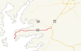
Maryland Route 363 is a state highway
in the U.S. state
of Maryland
. Known for almost all of its length as Deal Island Road, the state highway runs 18.3 miles (29.5 km) from a dead end in the community of Wenona
at the southern end of Deal Island
east to Mansion Avenue in Princess Anne
just east of the highway's intersection with U.S. Route 13
(US 13). MD 363 connects Princess Anne with the communities of Deal Island, Chance
, and Dames Quarter
on Tangier Sound
. The state highway was constructed starting around 1920 from Princess Anne. MD 363 reached Chance in the early 1930s. The state highway was extended to Deal Island when a modern bridge to the island was constructed in 1940. MD 363 was extended to its present terminus at Wenona in the late 1950s.
. Beyond the church, the state highway straightens out, passing by the old post office building and a boat ramp accessed from Ralph Abbott Road before a high-level bridge carries the state highway over Upper Thoroughfare, a strait between Laws Cove and Tangier Sound. On the north side of the bridge, MD 363 passes MD 363A, the north approach to the previous bridge to Deal Island, before passing through the community of Chance, the site of Rock Creek Methodist Episcopal Church
. After passing Haines Point Road, which leads to a large public boat ramp, the state highway continues northeast across the two branches of Rock Creek and through more marshland before entering Dames Quarter. MD 363 traverses Dames Quarter Creek and passes through Deal Island Wildlife Management Area
.
After passing through the wildlife management area, MD 363 heads east on a 5 miles (8 km) straight through the very small hamlets of St. Stephens and Monie and bypassing the village of Oriole
, which is accessed by Oriole Back Road from the west and MD 627
(Oriole Road) from the east. After passing Venton Road, which leads to All Saints Church
, the state highway traverses the Chesapeake Forest Lands. On the east edge of the forest, MD 363 curves northeast and then east toward Princess Anne, passing farmland, several residential subdivisions, and the Flying W Airport. Immediately after crossing the Manokin River
, the state highway reaches its intersection with US 13 (Ocean Highway). MD 363 continues east into the town of Princess Anne as Manokin Avenue, where the state highway reaches its eastern terminus at Mansion Avenue, named for the Teackle Mansion
one block to the south. The roadway continues east toward MD 675
(Somerset Avenue) in downtown Princess Anne.
.
{|class=wikitable
!Location
!Mile
!Destinations
!Notes
|-
|Deal Island
|0.00
|Dead end
|Western terminus
|-
|Oriole
|13.09
|
|
|-
|rowspan=2|Princess Anne
|18.19
|
|
|-
|18.30
|Manokin Avenue east / Mansion Avenue south
|Eastern terminus
State highway
State highway, state road or state route can refer to one of three related concepts, two of them related to a state or provincial government in a country that is divided into states or provinces :#A...
in the U.S. state
U.S. state
A U.S. state is any one of the 50 federated states of the United States of America that share sovereignty with the federal government. Because of this shared sovereignty, an American is a citizen both of the federal entity and of his or her state of domicile. Four states use the official title of...
of Maryland
Maryland
Maryland is a U.S. state located in the Mid Atlantic region of the United States, bordering Virginia, West Virginia, and the District of Columbia to its south and west; Pennsylvania to its north; and Delaware to its east...
. Known for almost all of its length as Deal Island Road, the state highway runs 18.3 miles (29.5 km) from a dead end in the community of Wenona
Wenona, Maryland
Wenona is an unincorporated community located on Deal Island in Somerset County, Maryland, United States. It is located at the western end of Maryland Route 363, Deal Island Road....
at the southern end of Deal Island
Deal Island, Maryland
Deal Island is a census-designated place in Somerset County, Maryland, United States. The population was 578 at the 2000 census. It is included in the Salisbury, Maryland Metropolitan Statistical Area...
east to Mansion Avenue in Princess Anne
Princess Anne, Maryland
Princess Anne is a town in Somerset County, Maryland, United States. The population was 2,313 at the 2000 census. It is the county seat of Somerset County.Princess Anne is included in the Salisbury, Maryland Metropolitan Statistical Area....
just east of the highway's intersection with U.S. Route 13
U.S. Route 13 in Maryland
U.S. Route 13 is a U.S. Highway running from Fayetteville, North Carolina north to Morrisville, Pennsylvania. In the U.S. state of Maryland, the route runs from the Virginia border south of Pocomoke City in Worcester County north to the Delaware border in Delmar, Wicomico County, where the route...
(US 13). MD 363 connects Princess Anne with the communities of Deal Island, Chance
Chance, Maryland
Chance is a census-designated place in Somerset County, Maryland, United States. The population was 377 at the 2000 census. It is included in the Salisbury, Maryland Metropolitan Statistical Area.-Geography:...
, and Dames Quarter
Dames Quarter, Maryland
Dames Quarter is a census-designated place in Somerset County, Maryland, United States. The population was 188 at the 2000 census. It is included in the Salisbury, Maryland Metropolitan Statistical Area.-Geography:...
on Tangier Sound
Tangier Sound
Tangier Sound is a sound of the Chesapeake Bay bounded on the west by Tangier Island in Virginia, and Smith Island and South Marsh Island in Maryland, by Deal Island in Maryland on the north, and the mainland of the Eastern Shore of Maryland and Pocomoke Sound on the east...
. The state highway was constructed starting around 1920 from Princess Anne. MD 363 reached Chance in the early 1930s. The state highway was extended to Deal Island when a modern bridge to the island was constructed in 1940. MD 363 was extended to its present terminus at Wenona in the late 1950s.
Route description
MD 363 begins at a dead end in the community of Wenona at the southern end of Deal Island. The state highway heads north, passing through a sharp curve before crossing Middle Creek. MD 363 runs through another series of sharp curves through marshland before passing St. John's Methodist Episcopal ChurchSt. John's Methodist Episcopal Church and Joshua Thomas Chapel
St. John's Methodist Episcopal Church and Joshua Thomas Chapel is a historic Methodist Episcopal church complex located at Deal Island, Somerset County, Maryland. The complex consists of St...
. Beyond the church, the state highway straightens out, passing by the old post office building and a boat ramp accessed from Ralph Abbott Road before a high-level bridge carries the state highway over Upper Thoroughfare, a strait between Laws Cove and Tangier Sound. On the north side of the bridge, MD 363 passes MD 363A, the north approach to the previous bridge to Deal Island, before passing through the community of Chance, the site of Rock Creek Methodist Episcopal Church
Rock Creek Methodist Episcopal Church
Rock Creek Methodist Episcopal Church is a historic Methodist Episcopal church located at Chance, Somerset County, Maryland. It is a cross-plan Gothic style church supported by a continuous common bond brick foundation, built in 1900. It features a three-story bell tower capped by a pyramidal spire...
. After passing Haines Point Road, which leads to a large public boat ramp, the state highway continues northeast across the two branches of Rock Creek and through more marshland before entering Dames Quarter. MD 363 traverses Dames Quarter Creek and passes through Deal Island Wildlife Management Area
Deal Island Wildlife Management Area
Deal Island Wildlife Management Area protects in western Somerset County near the community of Deal Island. As a wildlife management area, the area is...
.
After passing through the wildlife management area, MD 363 heads east on a 5 miles (8 km) straight through the very small hamlets of St. Stephens and Monie and bypassing the village of Oriole
Oriole, Maryland
Oriole is an unincorporated community in Somerset County, Maryland, United States.-References:...
, which is accessed by Oriole Back Road from the west and MD 627
Maryland Route 627
Maryland Route 627 is a state highway in the U.S. state of Maryland. Known as Oriole Road, the state highway runs from the intersection of Oriole Back Road and Crab Island Road in Oriole east to MD 363 near Oriole...
(Oriole Road) from the east. After passing Venton Road, which leads to All Saints Church
All Saints Church at Monie
All Saints Church at Monie is a historic Episcopal church located at Venton, Somerset County, Maryland. It is a single-story Carpenter Gothic-style building, five bays across by one room deep built in 1881. It is a well preserved example of a small, rural Carpenter Gothic church taken from the...
, the state highway traverses the Chesapeake Forest Lands. On the east edge of the forest, MD 363 curves northeast and then east toward Princess Anne, passing farmland, several residential subdivisions, and the Flying W Airport. Immediately after crossing the Manokin River
Manokin River
Manokin River is a river in Somerset County, Maryland, that flows into Tangier Sound, an arm of the Chesapeake Bay. The Manokin rises east of Princess Anne, Maryland, flows through the town, then widens into a tidal estuary. Tributaries along the river's length are Kings Creek, Back Creek, St....
, the state highway reaches its intersection with US 13 (Ocean Highway). MD 363 continues east into the town of Princess Anne as Manokin Avenue, where the state highway reaches its eastern terminus at Mansion Avenue, named for the Teackle Mansion
Teackle Mansion
The Teackle Mansion is a historic U.S. mansion located at 11736 Mansion Street, Princess Anne, Maryland, United States. The mansion was built between 1802 and 1819 for Littleton Dennis Teackle and his wife Elizabeth Upshur Teackle...
one block to the south. The roadway continues east toward MD 675
Maryland Route 675
Maryland Route 675 is a collection of state highways in the U.S. state of Maryland. These two highways are sections of old alignment of U.S. Route 13 in Princess Anne in Somerset County and Delmar in northern Wicomico County. MD 675 was designated after US 13 bypassed Princess Anne in the late...
(Somerset Avenue) in downtown Princess Anne.
History
MD 363 was under construction as a modern highway by 1921, when the highway had been completed from Princess Anne to the eastern end of the 5 miles (8 km) straight. The state highway reached Monie by 1923 and Dames Quarter in 1926. MD 363 was under construction west to Chance in 1930 and completed by 1933. The state highway's western terminus remained at Chance until 1940. MD 363 was extended to the other side of Upper Thoroughfare when a modern bridge replaced a causeway that had been in place since at least 1903. The state highway was widened in stages from Princess Anne between 1950 and 1958, culminating in the extension of MD 363 to Wenona in 1958. MD 363 originally continued east from its present terminus in Princess Anne along Mansion Avenue and Prince William Street to end at MD 675. The state highway assumed its present eastern terminus around 1985. The present bridge across Upper Thoroughfare was completed in 1987.Junction list
The entire route is in Somerset CountySomerset County, Maryland
-2010:Whereas according to the 2010 U.S. Census Bureau:*53.5% White*42.3% Black*0.3% Native American*0.7% Asian*0.0% Native Hawaiian or Pacific Islander*1.7% Two or more races*1.5% Other races*3.3% Hispanic or Latino -2000:...
.
{|class=wikitable
!Location
!Mile
!Destinations
!Notes
|-
|Deal Island
Deal Island, Maryland
Deal Island is a census-designated place in Somerset County, Maryland, United States. The population was 578 at the 2000 census. It is included in the Salisbury, Maryland Metropolitan Statistical Area...
|0.00
|Dead end
|Western terminus
|-
|Oriole
Oriole, Maryland
Oriole is an unincorporated community in Somerset County, Maryland, United States.-References:...
|13.09
|
|
|-
|rowspan=2|Princess Anne
Princess Anne, Maryland
Princess Anne is a town in Somerset County, Maryland, United States. The population was 2,313 at the 2000 census. It is the county seat of Somerset County.Princess Anne is included in the Salisbury, Maryland Metropolitan Statistical Area....
|18.19
|
|
|-
|18.30
|Manokin Avenue east / Mansion Avenue south
|Eastern terminus