
Maryland Route 178
Encyclopedia
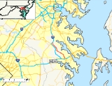
Maryland Route 178, known locally as Generals Highway, is a north–south highway in Anne Arundel County, Maryland
. It parallels Interstate 97
and once was the main eastbound route to Annapolis, Maryland
. It begins at its intersection with Maryland Route 450
in Parole
, near the Westfield Annapolis. The route heads north, traveling through the communities of Crownsville
and Millersville
before ending at Veterans Highway, the former alignment of northbound Maryland Route 3
. Generals Highway was so named because General George Washington traveled this road to Annapolis to formally resign his commission after the Revolution.
area of Anne Arundel County
. From this intersection, MD 178 travels south through a primarily residential area as a two-lane roadway, where it has two signalized intersections at Millersville Rd and Sunrise Beach Rd, in addition to an intersection with Waterbury Rd. As the road approaches the ramps to and from I-97
, the road makes a sharp curve to intersect in a T-intersection with the ramps. At the intersection, motorists on MD 178 must make a left turn to continue on the route, or they can choose to turn right and access northbound I-97. It is noted that this exit with I-97 only provides access to northbound I-97 and from southbound I-97.
Heading south from its intersection with the I-97 ramps, MD 178 enters the Crownsville
area of the county where it exists as a two-lane road. This section of the route is also primarily residential in nature, with signalized intersection at Herald Harbor Rd located just south of the I-97 ramps. From there, the next major intersection occurs at Crownsville Rd, which leads towards the Maryland Renaissance Festival
. Past the intersection with Crownsville Road, MD 178 continues south through the signalized intersections with Old Generals Highway and Epping Forest Rd and past the Anne Arundel County Fairgrounds before entering Parole
.
Once in Parole, MD 178 is a four-lane highway traveling through a principally commercial area. The major intersection of Bestgate Road / Housley Rd provides an alternate route to Annapolis via MD 70
over West St
. Heading south towards its terminus, the Westfield Annapolis fronts the east side of the route. After approximately 0.35 mile (0.563269 km), MD 178 ends at the major intersection of MD 450
. At this intersection, MD 450 intersects from the west as Defense Highway and continues south as West St. A major mall access intersects from the east. Continuing south through the intersection on MD 450 will provide access to US 50 / US 301, MD 2
, and the city of Annapolis
.
.
Maryland
Maryland is a U.S. state located in the Mid Atlantic region of the United States, bordering Virginia, West Virginia, and the District of Columbia to its south and west; Pennsylvania to its north; and Delaware to its east...
. It parallels Interstate 97
Interstate 97
Interstate 97 is an intrastate Interstate Highway located entirely within Anne Arundel County, Maryland, United States. It runs from Annapolis at the overlapped section of US 50, US 301, and the unsigned I-595 to Baltimore at the city's beltway...
and once was the main eastbound route to Annapolis, Maryland
Annapolis, Maryland
Annapolis is the capital of the U.S. state of Maryland, as well as the county seat of Anne Arundel County. It had a population of 38,394 at the 2010 census and is situated on the Chesapeake Bay at the mouth of the Severn River, south of Baltimore and about east of Washington, D.C. Annapolis is...
. It begins at its intersection with Maryland Route 450
Maryland Route 450
Maryland Route 450 is a state highway in the U.S. state of Maryland. The state highway runs from U.S. Route 1 Alternate in Bladensburg east to US 50, US 301, and MD 2 near Annapolis. MD 450 is the original alignment of US 50 in Prince George's and Anne Arundel Counties...
in Parole
Parole, Maryland
Parole is a census-designated place in Anne Arundel County, Maryland, United States. The population was 14,031 at the 2000 census. It is where several major roads intersect at the edge of the state capital, Annapolis, and adjacent to the Annapolis Mall shopping center and Anne Arundel Medical Center...
, near the Westfield Annapolis. The route heads north, traveling through the communities of Crownsville
Crownsville, Maryland
Crownsville is a census-designated place in Anne Arundel County, Maryland, United States. The population was 1,670 at the 2000 census. It hosts the Anne Arundel County Fair each September, as well as the annual Maryland Renaissance Festival for several summer weekends. A state psychiatric hospital...
and Millersville
Millersville, Maryland
Millersville is an unincorporated community in Anne Arundel County, Maryland, United States.-Geography:Millersville is located at .-History:...
before ending at Veterans Highway, the former alignment of northbound Maryland Route 3
Maryland Route 3
Maryland Route 3, also part of Robert Crain Highway, is the designation given to the former alignment of U.S. Route 301 from Bowie, Maryland, USA, to Baltimore. It is named for Robert Crain of Baltimore.-Route description:...
. Generals Highway was so named because General George Washington traveled this road to Annapolis to formally resign his commission after the Revolution.
Route description
MD 178 starts at a T-intersection with Veterans Highway in the MillersvilleMillersville, Maryland
Millersville is an unincorporated community in Anne Arundel County, Maryland, United States.-Geography:Millersville is located at .-History:...
area of Anne Arundel County
Anne Arundel County, Maryland
Anne Arundel County is a county located in the U.S. state of Maryland. It is named for Anne Arundell , a member of the ancient family of Arundells in Cornwall, England and the wife of Cæcilius Calvert, 2nd Baron Baltimore. Its county seat is Annapolis, which is also the capital of the state...
. From this intersection, MD 178 travels south through a primarily residential area as a two-lane roadway, where it has two signalized intersections at Millersville Rd and Sunrise Beach Rd, in addition to an intersection with Waterbury Rd. As the road approaches the ramps to and from I-97
Interstate 97
Interstate 97 is an intrastate Interstate Highway located entirely within Anne Arundel County, Maryland, United States. It runs from Annapolis at the overlapped section of US 50, US 301, and the unsigned I-595 to Baltimore at the city's beltway...
, the road makes a sharp curve to intersect in a T-intersection with the ramps. At the intersection, motorists on MD 178 must make a left turn to continue on the route, or they can choose to turn right and access northbound I-97. It is noted that this exit with I-97 only provides access to northbound I-97 and from southbound I-97.
Heading south from its intersection with the I-97 ramps, MD 178 enters the Crownsville
Crownsville, Maryland
Crownsville is a census-designated place in Anne Arundel County, Maryland, United States. The population was 1,670 at the 2000 census. It hosts the Anne Arundel County Fair each September, as well as the annual Maryland Renaissance Festival for several summer weekends. A state psychiatric hospital...
area of the county where it exists as a two-lane road. This section of the route is also primarily residential in nature, with signalized intersection at Herald Harbor Rd located just south of the I-97 ramps. From there, the next major intersection occurs at Crownsville Rd, which leads towards the Maryland Renaissance Festival
Maryland Renaissance Festival
The Maryland Renaissance Festival is a Renaissance fair located in Crownsville, Maryland. Set in a fictional 16th century English village named Revel Grove, the festival is spread over and is the second largest renaissance festival in the United States...
. Past the intersection with Crownsville Road, MD 178 continues south through the signalized intersections with Old Generals Highway and Epping Forest Rd and past the Anne Arundel County Fairgrounds before entering Parole
Parole, Maryland
Parole is a census-designated place in Anne Arundel County, Maryland, United States. The population was 14,031 at the 2000 census. It is where several major roads intersect at the edge of the state capital, Annapolis, and adjacent to the Annapolis Mall shopping center and Anne Arundel Medical Center...
.
Once in Parole, MD 178 is a four-lane highway traveling through a principally commercial area. The major intersection of Bestgate Road / Housley Rd provides an alternate route to Annapolis via MD 70
Maryland Route 170
Maryland Route 170 is a roughly 13-mile-long road in Anne Arundel County.-Route description:MD 170 begins at the intersection of MD 175 Annapolis Road and Piney Orchard Parkway, in Odenton. It runs north towards Severn, interchanging with MD 32 northwest of the town...
over West St
Maryland Route 450
Maryland Route 450 is a state highway in the U.S. state of Maryland. The state highway runs from U.S. Route 1 Alternate in Bladensburg east to US 50, US 301, and MD 2 near Annapolis. MD 450 is the original alignment of US 50 in Prince George's and Anne Arundel Counties...
. Heading south towards its terminus, the Westfield Annapolis fronts the east side of the route. After approximately 0.35 mile (0.563269 km), MD 178 ends at the major intersection of MD 450
Maryland Route 450
Maryland Route 450 is a state highway in the U.S. state of Maryland. The state highway runs from U.S. Route 1 Alternate in Bladensburg east to US 50, US 301, and MD 2 near Annapolis. MD 450 is the original alignment of US 50 in Prince George's and Anne Arundel Counties...
. At this intersection, MD 450 intersects from the west as Defense Highway and continues south as West St. A major mall access intersects from the east. Continuing south through the intersection on MD 450 will provide access to US 50 / US 301, MD 2
Maryland Route 2
Maryland Route 2 is the longest state highway in the U.S. state of Maryland. The route runs from Solomons Island in Calvert County north to an intersection with U.S. Route 1 and U.S. Route 40 Truck in Baltimore...
, and the city of Annapolis
Annapolis, Maryland
Annapolis is the capital of the U.S. state of Maryland, as well as the county seat of Anne Arundel County. It had a population of 38,394 at the 2010 census and is situated on the Chesapeake Bay at the mouth of the Severn River, south of Baltimore and about east of Washington, D.C. Annapolis is...
.
Junction list
The entire route is located in Anne Arundel CountyAnne Arundel County, Maryland
Anne Arundel County is a county located in the U.S. state of Maryland. It is named for Anne Arundell , a member of the ancient family of Arundells in Cornwall, England and the wife of Cæcilius Calvert, 2nd Baron Baltimore. Its county seat is Annapolis, which is also the capital of the state...
.
| Location | Mile | Intersection | Notes |
|---|---|---|---|
| Parole Parole, Maryland Parole is a census-designated place in Anne Arundel County, Maryland, United States. The population was 14,031 at the 2000 census. It is where several major roads intersect at the edge of the state capital, Annapolis, and adjacent to the Annapolis Mall shopping center and Anne Arundel Medical Center... |
0.00 | Access to Westfield Annapolis also at this intersection. | |
| 0.34 | Bestgate Road / Housley Road | Eastbound leads to MD 70 | |
| Crownsville Crownsville, Maryland Crownsville is a census-designated place in Anne Arundel County, Maryland, United States. The population was 1,670 at the 2000 census. It hosts the Anne Arundel County Fair each September, as well as the annual Maryland Renaissance Festival for several summer weekends. A state psychiatric hospital... |
1.00 | Epping Forest Road | |
| 2.56 | |||
| 4.20 | Crownsville Road | ||
| 5.09 | Herald Harbor Road | Old MD 465 | |
| 5.35 | Exit 5 | ||
| Millersville Millersville, Maryland Millersville is an unincorporated community in Anne Arundel County, Maryland, United States.-Geography:Millersville is located at .-History:... |
6.12 | Waterbury Road | |
| 6.42 | Sunrise Beach Road | ||
| 7.12 | Millersville Road | ||
| 8.06 | Veterans Highway | Terminus | |