

Manitoba Provincial Road 280
Encyclopedia
Provincial Road 280 is a road in the Canadian province of Manitoba
. It runs from Provincial Road 391
northwest of Thompson
to local streets in Gillam
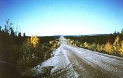
. The route is 291 kilometres (180.8 mi) long, which during its length, passes several large lakes and intersects with one provincial road, Road 290, just north of Gillam. The route is very scenic, passing through dense forests and rural lands. The route supplies three municipalities, Thompson, Split Lake
, and Gillam. Before Road 280 was constructed, the only access to the village of Gillam were via a railroad that ran across the Hudson Bay Railway. This railway serves much of the towns accessible from Road 280 and nearby Road 391. The railway also continues along Road 290 towards Sundance.
Road 280 is the only car access road to Gillam. From its terminus north of Thompson, Manitoba
to the town Gillam, PR 280 is classified as a Class A1 Provincial Route. Churchill, on Hudson Bay, can be accessed by VIA RAIL (passenger train "The Hudson Bay", VIA 692 south and VIA 693 north from Winnipeg three days per week) on the Hudson Bay Railway (freight) line. The PR 280 affords access to this more northerly transportation route at a couple of junctions.
 Provincial Road 280 begins at an intersection with Manitoba Provincial Road 391
(the continuation of Highway 6) in Thompson
, just north of the city airport. Road 280 proceeds to the northeast through rural regions of northeastern Manitoba
as it leaves the city of Thompson. Route 280 passes through a few forests to the north of Thompson and becomes a short divided highway. The highway continues, intersecting with a few local roads in Mystery Lake
.
Route 280 continues to the northeast as it passes near the shores of Mystery Lake. The highway leaves Mystery Lake and proceeds through more rural areas. Around 20.1 kilometres (12.5 mi), Route 280 intersects with a local road that continues back towards Mystery Lake. A short while later, the rural route passes a small parking lot in a dense forest. The route continues through the forest and curves to the east slightly. A short while later, Route 280 passes a pond just before intersecting with local roads that reach Moak Lake. Just northeast of that, Route 280 intersecting with an old woods road. Route 280 passes to the northeast of Moak Lake and begins to parallel the old woods road. The woods road merges in after 28 kilometres (17.4 mi) and Route 280 passes another parking lot in a dense forest to the north. The highway passes to the north of a mountain and continues to parallel Moak Lake, which is to the south. Route 280 leaves Moak Lake in its wake and continues to the east/northeast towards Split Lake. For a while, Route 280 intersects with local roads and passes through forests.
 The highway curves to the east and passes to the south of a glacier at around 45 kilometres (28 mi). Route 280 turns to the northeast again and heads towards Split Lake. The highway turns to the east again near a large pond. Route 280 intersects with a dead end woods road again around 49 kilometres (30.4 mi). Route 280 passes to the south of a large pond and later a large gap in the forest. Route 280 makes several changes in direction before passing Orr Lake to the north and a river to the south. At about 69 kilometres (42.9 mi), Route 280 begins to parallel a river for the next 24 kilometres (14.9 mi). The river drains into Split Lake
while Route 280 passes to the north near Assean Lake.
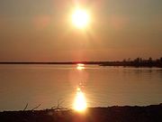 Route 280 passes north of Split Lake, intersecting with two local roads, one of which becomes a ferry to York Landing. Route 280 turns to the north, passing to the east of Assean Lake. Assean Lake becomes a river and parallels Route 280 to the north. At 125 kilometres (77.7 mi)s, Route 280 passes to the northeast of downtown Split Lake, which is accessible by a local road off the highway. The next 70 kilometres (43.5 mi) is dense forest and unpaved roadway. The highway begins to parallel Stephens Lake at 201 kilometres (124.9 mi). At 260 kilometres (161.6 mi), Route 280 turns to the south at a fork with Manitoba Provincial Road 290
.
Route 280 heads across a bridge over Stephens Lake and heads southward for 20 miles (32.2 km), where it enters Gillam
. At 291 kilometres (180.8 mi), Route 280 terminates at a local road in Gillam.
 Before Route 280 existed, the only ways to the northern terminus town of Gillam was via a nearby airport to the southeast of town and the HBR railroad line that stretched from Thompson to northern parts of Manitoba
. The railroad opened in 1929.
On March 28, 2002, the government of Manitoba order out an CAD$
84.8 million plan to work on its province's roads. $940,000 was spent for gravel stabilization beginning at PR 391 and ending in Gillam. This work was also under the Community Main Access Gravel Road Stabilization Program. $700,000 of this $84 million went for additional gravel between 391 and PR 290. $600,000 went to road development near Wasakamew Lake, 52 kilometres (32.3 mi) north of PR 391.
The Ininew (Cree) Indian Reserve of York Landing, Manitoba
depends heavily on PR 280 for supplies of bulk goods. In April 2001, alternate route systems were blueprinted to make an all-winter road. The first was an all weather-road via the town of Birthday Rapids. It would cost $45 million including a bridge over the Nelson River in Split Lake
. Being that most road access is from Thompson, there would be a 95 kilometres (59 mi) detour to the PR 280/Split Lake Road intersection, providing access to the town of Ilford and eliminating the need for a ferry crossing to York Landing.
The second plan was an all-weather road via the proposed Gull Lake Hydro-Electric Dam. This plan would cost $47 million, including a 180 kilometres (111.8 mi) detour to the same intersection, PR 280/Split Lake Road. This option did propose an all-weather road to both Ilford and Gillam. The nearby Nelson River would be used for the Gull Rapids hydro-electric generating station. The third choice, most preferred by the community of York Landing, would cost $65 million and provide the most access to Provincial Road 280. The road would be 75 kilometres (46.6 mi) long and need bridges over the Odei, Grass and Burntwood Rivers. The fourth plan would not effect PR 280 in any way.
Manitoba
Manitoba is a Canadian prairie province with an area of . The province has over 110,000 lakes and has a largely continental climate because of its flat topography. Agriculture, mostly concentrated in the fertile southern and western parts of the province, is vital to the province's economy; other...
. It runs from Provincial Road 391
Manitoba Provincial Road 391
Provincial Road 391 is an all-weather gravel road connecting Thompson and Lynn Lake House, in the Canadian province of Manitoba. PR 391 is located in the Wapisu Range.PR 391 passes through Leaf Rapids a community situated northwest of Thompson...
northwest of Thompson
Thompson, Manitoba
Thompson is a city in northern Manitoba. As the "Hub of the North" it serves as the regional trade and service centre of northern Manitoba. Thompson is located north of the Canada – United States border, north of the provincial capital of Winnipeg, and is northeast of Flin Flon...
to local streets in Gillam
Gillam, Manitoba
Gillam, Manitoba, Canada, is a community between Thompson and Churchill on the Hudson Bay Railway line. Gillam is a significant community because of the nearby Nelson River Bipole converter station on the Nelson River...
. The route is 291 kilometres (180.8 mi) long, which during its length, passes several large lakes and intersects with one provincial road, Road 290, just north of Gillam. The route is very scenic, passing through dense forests and rural lands. The route supplies three municipalities, Thompson, Split Lake
Split Lake, Manitoba
Split Lake is a community in Manitoba on the north shore of Split Lake on Nelson River about 150 miles west southwest of the river's mouth at Hudson Bay....
, and Gillam. Before Road 280 was constructed, the only access to the village of Gillam were via a railroad that ran across the Hudson Bay Railway. This railway serves much of the towns accessible from Road 280 and nearby Road 391. The railway also continues along Road 290 towards Sundance.
Road 280 is the only car access road to Gillam. From its terminus north of Thompson, Manitoba
Thompson, Manitoba
Thompson is a city in northern Manitoba. As the "Hub of the North" it serves as the regional trade and service centre of northern Manitoba. Thompson is located north of the Canada – United States border, north of the provincial capital of Winnipeg, and is northeast of Flin Flon...
to the town Gillam, PR 280 is classified as a Class A1 Provincial Route. Churchill, on Hudson Bay, can be accessed by VIA RAIL (passenger train "The Hudson Bay", VIA 692 south and VIA 693 north from Winnipeg three days per week) on the Hudson Bay Railway (freight) line. The PR 280 affords access to this more northerly transportation route at a couple of junctions.
Route description
Manitoba Provincial Road 391
Provincial Road 391 is an all-weather gravel road connecting Thompson and Lynn Lake House, in the Canadian province of Manitoba. PR 391 is located in the Wapisu Range.PR 391 passes through Leaf Rapids a community situated northwest of Thompson...
(the continuation of Highway 6) in Thompson
Thompson, Manitoba
Thompson is a city in northern Manitoba. As the "Hub of the North" it serves as the regional trade and service centre of northern Manitoba. Thompson is located north of the Canada – United States border, north of the provincial capital of Winnipeg, and is northeast of Flin Flon...
, just north of the city airport. Road 280 proceeds to the northeast through rural regions of northeastern Manitoba
Manitoba
Manitoba is a Canadian prairie province with an area of . The province has over 110,000 lakes and has a largely continental climate because of its flat topography. Agriculture, mostly concentrated in the fertile southern and western parts of the province, is vital to the province's economy; other...
as it leaves the city of Thompson. Route 280 passes through a few forests to the north of Thompson and becomes a short divided highway. The highway continues, intersecting with a few local roads in Mystery Lake
Mystery Lake, Manitoba
Mystery Lake is a local government district in northern Manitoba. It surrounds the city of Thompson.In 2006, according to Statistics Canada census data, Mystery Lake had a population of 147 living in 79 dwellings, a 2,840.0% increase from 2001. The LGD has a land area of and a population density...
.
Route 280 continues to the northeast as it passes near the shores of Mystery Lake. The highway leaves Mystery Lake and proceeds through more rural areas. Around 20.1 kilometres (12.5 mi), Route 280 intersects with a local road that continues back towards Mystery Lake. A short while later, the rural route passes a small parking lot in a dense forest. The route continues through the forest and curves to the east slightly. A short while later, Route 280 passes a pond just before intersecting with local roads that reach Moak Lake. Just northeast of that, Route 280 intersecting with an old woods road. Route 280 passes to the northeast of Moak Lake and begins to parallel the old woods road. The woods road merges in after 28 kilometres (17.4 mi) and Route 280 passes another parking lot in a dense forest to the north. The highway passes to the north of a mountain and continues to parallel Moak Lake, which is to the south. Route 280 leaves Moak Lake in its wake and continues to the east/northeast towards Split Lake. For a while, Route 280 intersects with local roads and passes through forests.
Split Lake, Manitoba
Split Lake is a community in Manitoba on the north shore of Split Lake on Nelson River about 150 miles west southwest of the river's mouth at Hudson Bay....
while Route 280 passes to the north near Assean Lake.
Manitoba Provincial Road 290
Manitoba Provincial Road 290 is a provincial road in the Canadian province of Manitoba. Road 290 begins at an intersection with Manitoba Provincial Road 280 in Stephens Lake and heads to the northeast to the abandoned town of Sundance...
.
Route 280 heads across a bridge over Stephens Lake and heads southward for 20 miles (32.2 km), where it enters Gillam
Gillam, Manitoba
Gillam, Manitoba, Canada, is a community between Thompson and Churchill on the Hudson Bay Railway line. Gillam is a significant community because of the nearby Nelson River Bipole converter station on the Nelson River...
. At 291 kilometres (180.8 mi), Route 280 terminates at a local road in Gillam.
History
Manitoba
Manitoba is a Canadian prairie province with an area of . The province has over 110,000 lakes and has a largely continental climate because of its flat topography. Agriculture, mostly concentrated in the fertile southern and western parts of the province, is vital to the province's economy; other...
. The railroad opened in 1929.
On March 28, 2002, the government of Manitoba order out an CAD$
Canadian dollar
The Canadian dollar is the currency of Canada. As of 2007, the Canadian dollar is the 7th most traded currency in the world. It is abbreviated with the dollar sign $, or C$ to distinguish it from other dollar-denominated currencies...
84.8 million plan to work on its province's roads. $940,000 was spent for gravel stabilization beginning at PR 391 and ending in Gillam. This work was also under the Community Main Access Gravel Road Stabilization Program. $700,000 of this $84 million went for additional gravel between 391 and PR 290. $600,000 went to road development near Wasakamew Lake, 52 kilometres (32.3 mi) north of PR 391.
The Ininew (Cree) Indian Reserve of York Landing, Manitoba
York Landing, Manitoba
York Landing, Manitoba is a community in Manitoba, Canada. It is located along the eastern bank of the Nelson River, roughly half-way between Lake Winnipeg and Hudson Bay, and it is located 116 kilometers from Thompson, Manitoba. The community has a population of 464 and it consists of 123 dwellings...
depends heavily on PR 280 for supplies of bulk goods. In April 2001, alternate route systems were blueprinted to make an all-winter road. The first was an all weather-road via the town of Birthday Rapids. It would cost $45 million including a bridge over the Nelson River in Split Lake
Split Lake, Manitoba
Split Lake is a community in Manitoba on the north shore of Split Lake on Nelson River about 150 miles west southwest of the river's mouth at Hudson Bay....
. Being that most road access is from Thompson, there would be a 95 kilometres (59 mi) detour to the PR 280/Split Lake Road intersection, providing access to the town of Ilford and eliminating the need for a ferry crossing to York Landing.
The second plan was an all-weather road via the proposed Gull Lake Hydro-Electric Dam. This plan would cost $47 million, including a 180 kilometres (111.8 mi) detour to the same intersection, PR 280/Split Lake Road. This option did propose an all-weather road to both Ilford and Gillam. The nearby Nelson River would be used for the Gull Rapids hydro-electric generating station. The third choice, most preferred by the community of York Landing, would cost $65 million and provide the most access to Provincial Road 280. The road would be 75 kilometres (46.6 mi) long and need bridges over the Odei, Grass and Burntwood Rivers. The fourth plan would not effect PR 280 in any way.