
Mangaroa Railway Station
Encyclopedia
Wairarapa Line
The Wairarapa Line is a secondary railway line in the south-east of the North Island of New Zealand, connecting the capital city of Wellington with the Wairarapa region. The line ends at Woodville, where it joins the Palmerston North - Gisborne Line...
between Upper Hutt
Upper Hutt
Upper Hutt is a satellite city of Wellington. It is New Zealand's smallest city by population, the second largest by land area. It is in Greater Wellington.-Geography:Upper Hutt is 30 km north-east of Wellington...
and Featherston
Featherston, New Zealand
Featherston is a town in the north of the Wellington Region region of New Zealand. It lies in the Wairarapa, just north of the Rimutaka Tunnel, in the South Wairarapa District. The population was 2,340 in the 2006 Census....
in the Wellington
Wellington
Wellington is the capital city and third most populous urban area of New Zealand, although it is likely to have surpassed Christchurch due to the exodus following the Canterbury Earthquake. It is at the southwestern tip of the North Island, between Cook Strait and the Rimutaka Range...
region of New Zealand
New Zealand
New Zealand is an island country in the south-western Pacific Ocean comprising two main landmasses and numerous smaller islands. The country is situated some east of Australia across the Tasman Sea, and roughly south of the Pacific island nations of New Caledonia, Fiji, and Tonga...
’s North Island, on the section that was replaced by the Rimutaka Deviation in 1955. It served the small rural settlement of Mangaroa
Mangaroa
Mangaroa is a rural suburb of Upper Hutt situated in the lower North Island of New Zealand. It is home to Mangaroa School, and previously the Mangaroa Railway Station....
, in the Mangaroa Valley, east of Upper Hutt
Upper Hutt
Upper Hutt is a satellite city of Wellington. It is New Zealand's smallest city by population, the second largest by land area. It is in Greater Wellington.-Geography:Upper Hutt is 30 km north-east of Wellington...
.
History
Mangaroa station was not originally built prior to the opening of Kaitoke stationKaitoke Railway Station
Kaitoke railway station was a single-platform rural railway station on the Wairarapa Line between Upper Hutt and Featherston in the Wellington region of New Zealand’s North Island. Initially it was the railhead of the Wairarapa Line, at a point where the railway met the main road between Upper...
as part of the Mungaroa Contract.
During the construction of the Rimutaka Tunnel, a siding was laid from the eastern end of the Mangaroa Valley and several chains north-east of Mangaroa station to the new Maymorn Station
Maymorn Railway Station
Maymorn railway station is a twin platform, rural railway station serving the small settlement of Maymorn on the Maymorn Plateau, east of Upper Hutt, in New Zealand’s North Island...
yard. This was to enable work trains to bring lengths of welded rail, other supplies and equipment from the Hutt Workshops directly to the construction site. Once the tunnel and deviation opened, this siding, along with the rest of the old section, was lifted in 1956.
A military siding was established at Mangaroa in World War II to service RNZAF No. 2 Stores Depot that was later used by the Army. The depot opened in 1942 after being moved from the RNZAF station at Rongotai and was used until after the war. After the war the depot was a disposal site for surplus stores until RNZAF use ceased in July 1949, at which time it is assumed that the site was transferred to the NZ Army for their use.
Proposals
Prior to the construction of the Rimutaka Tunnel, several proposals for a tunnel under the Rimutaka Ranges to bypass the Incline section involved tunnels with a western portal to the north-east of Mangaroa station.In 1898 a survey was completed for a 5 miles (8 km) tunnel between Mangaroa and Cross Creek. The idea received a great deal of attention, but ultimately went nowhere as such a tunnel could not be contemplated at the time.
In 1921–1922, a feasibility study was conducted which again considered the possibility of a Mangaroa to Cross Creek tunnel. This would involve an improved gradient from Upper Hutt, followed by a 5 miles (8.0467 km) tunnel on a maximum gradient of 1 in 132. Again, the Public Works Department did no further work on the idea.
In 1936 the Government announced its intention to proceed with a Mangaroa to Cross Creek tunnel. Though new surveys were conducted in 1938–1939, the project was delayed once more, this time by war conditions. After the war when work restarted on a tunnel through the Rimutaka Ranges, it followed an alignment that bypassed Mangaroa altogether.
Today
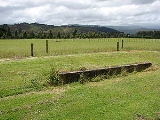
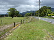
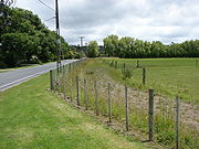
Very little of the old railway formation remains between the west and east sides of the Mangaroa Valley. Cruickshanks Tunnel still exists, though there is no formal access to it and the status of public access is uncertain. The only remains of the old Mangaroa River bridge are a few wooden bridge piles. There is still a noticeable hump in Flux Road just before the T-intersection with Leonards Road, the site of a level crossing just before the station.Of the station itself only the loading bank remains, at the side of Flux Road.
External links
- Rimutaka Incline Railway. Newsletter #8, Connection to heritage route at Maymorn for a plan view and brief description of the siding that linked the old and new lines during the construction of the Rimutaka Tunnel.
- Cruickshanks Tunnel.