

Maitland, Missouri
Encyclopedia
Maitland is a city in Holt County
, Missouri
, United States
. The population was 342 at the 2000 census which at one point billed itself as the "Bluegrass Mecca" -- home to the largest bluegrass farm in the world.
before eventually being abandoned.
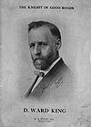
 The town is a farming community. One of the neighbor farmers was David Ward King
, inventor and promoter of the King road drag
-- an invention that essentially was two logs lashed together and dragged behind horse or mule teams that was an effective and inexpensive method to grade dirt roads. It was the horse drawn forerunner of the modern road grader. The invention came at the time Henry Ford started to mass produce automobiles. Before its invention, wet country roads became muck and were often nearly impassable. The use of the King Road Drag kept rural roads solid, even when wet, which made them passable all the time. These improved rural roads made possible both the advent of the automobile and rural mail delivery.
In the first half of the 20th Century, Maitland claimed to have the largest bluegrass
seed producing farm in the world. John Q. Weller was to claim that the 10000000 pounds (4,535,923.7 kg) of seed produced on his farm was more than the harvested seed output of the entire state of Kentucky. In some years, Weller would get permission to pile up bumper crops of seed on the city streets. During the harvest time in late June/early July, the town hosted a Bluegrass festival.
Bluegrass seed production in the late 1950s/early 1960s moved to farming communities in Idaho, Oregon, and Washington. The Festival has been discontinued.
According to the United States Census Bureau
, the city has a total area of 0.3 square mile (0.776996433 km²), all of it land.
of 2000, there were 342 people, 143 households, and 90 families residing in the city. The population density
was 1,179.7 people per square mile (455.3/km²). There were 173 housing units at an average density of 596.7 per square mile (230.3/km²). The racial makeup of the city was 100.00% White. Hispanic or Latino of any race were 0.29% of the population.
There were 143 households out of which 32.2% had children under the age of 18 living with them, 48.3% were married couples
living together, 8.4% had a female householder with no husband present, and 36.4% were non-families. 32.9% of all households were made up of individuals and 18.2% had someone living alone who was 65 years of age or older. The average household size was 2.39 and the average family size was 3.08.
In the city the population was spread out with 27.8% under the age of 18, 7.9% from 18 to 24, 24.3% from 25 to 44, 24.3% from 45 to 64, and 15.8% who were 65 years of age or older. The median age was 38 years. For every 100 females there were 112.4 males. For every 100 females age 18 and over, there were 102.5 males.
The median income for a household in the city was $31,250, and the median income for a family was $39,500. Males had a median income of $30,250 versus $18,750 for females. The per capita income
for the city was $13,743. About 6.0% of families and 10.9% of the population were below the poverty line, including 13.3% of those under age 18 and 8.3% of those age 65 or over.
Holt County, Missouri
Holt County is a county located in the U.S. state of Missouri. The county is in the northwest part of the state. As of 2010, the population was 4,912. Its county seat is Oregon. The county was organized in 1841 and is named after the Missouri state legislator Dr...
, Missouri
Missouri
Missouri is a US state located in the Midwestern United States, bordered by Iowa, Illinois, Kentucky, Tennessee, Arkansas, Oklahoma, Kansas and Nebraska. With a 2010 population of 5,988,927, Missouri is the 18th most populous state in the nation and the fifth most populous in the Midwest. It...
, United States
United States
The United States of America is a federal constitutional republic comprising fifty states and a federal district...
. The population was 342 at the 2000 census which at one point billed itself as the "Bluegrass Mecca" -- home to the largest bluegrass farm in the world.
History
The town is named for John Skirving Maitland who was a surveyor for the Nodaway Valley Railroad (the construction company for the Kansas City, St. Joseph and Council Bluffs Railroad) that arrived in Maitland in 1880 when its superintendent John Fisk Barnard bought the land for the town from John S. and Delila Swope. The railroad would eventually be taken over by the Burlington Northern RailroadBurlington Northern Railroad
The Burlington Northern Railroad was a United States-based railroad company formed from a merger of four major U.S. railroads. Burlington Northern operated between 1970 and 1996....
before eventually being abandoned.
David Ward King
David Ward King , a farmer who lived near Maitland, Missouri, was the inventor of the King road drag. His invention, which was the horse-drawn forerunner of the modern road grader, had great influence on American life because his invention improved the widespread dirt roads of his day to the extent...
, inventor and promoter of the King road drag
King road drag
The King road drag was a road grader implement for grading dirt roads that revolutionized the maintenance of the dirt roads in the early 1900s. It was invented by David Ward King, who went by "D...
-- an invention that essentially was two logs lashed together and dragged behind horse or mule teams that was an effective and inexpensive method to grade dirt roads. It was the horse drawn forerunner of the modern road grader. The invention came at the time Henry Ford started to mass produce automobiles. Before its invention, wet country roads became muck and were often nearly impassable. The use of the King Road Drag kept rural roads solid, even when wet, which made them passable all the time. These improved rural roads made possible both the advent of the automobile and rural mail delivery.
In the first half of the 20th Century, Maitland claimed to have the largest bluegrass
Smooth Meadow-grass
Poa pratensis, commonly known as Kentucky Bluegrass, Smooth Meadow-grass, or Common Meadow-grass, is a perennial species of grass native to Europe, Asia, and northern Africa.-General description:...
seed producing farm in the world. John Q. Weller was to claim that the 10000000 pounds (4,535,923.7 kg) of seed produced on his farm was more than the harvested seed output of the entire state of Kentucky. In some years, Weller would get permission to pile up bumper crops of seed on the city streets. During the harvest time in late June/early July, the town hosted a Bluegrass festival.
Bluegrass seed production in the late 1950s/early 1960s moved to farming communities in Idaho, Oregon, and Washington. The Festival has been discontinued.
Geography
Maitland is located at 40°12′5"N 95°4′32"W (40.201256, -95.075533).According to the United States Census Bureau
United States Census Bureau
The United States Census Bureau is the government agency that is responsible for the United States Census. It also gathers other national demographic and economic data...
, the city has a total area of 0.3 square mile (0.776996433 km²), all of it land.
Demographics
As of the censusCensus
A census is the procedure of systematically acquiring and recording information about the members of a given population. It is a regularly occurring and official count of a particular population. The term is used mostly in connection with national population and housing censuses; other common...
of 2000, there were 342 people, 143 households, and 90 families residing in the city. The population density
Population density
Population density is a measurement of population per unit area or unit volume. It is frequently applied to living organisms, and particularly to humans...
was 1,179.7 people per square mile (455.3/km²). There were 173 housing units at an average density of 596.7 per square mile (230.3/km²). The racial makeup of the city was 100.00% White. Hispanic or Latino of any race were 0.29% of the population.
There were 143 households out of which 32.2% had children under the age of 18 living with them, 48.3% were married couples
Marriage
Marriage is a social union or legal contract between people that creates kinship. It is an institution in which interpersonal relationships, usually intimate and sexual, are acknowledged in a variety of ways, depending on the culture or subculture in which it is found...
living together, 8.4% had a female householder with no husband present, and 36.4% were non-families. 32.9% of all households were made up of individuals and 18.2% had someone living alone who was 65 years of age or older. The average household size was 2.39 and the average family size was 3.08.
In the city the population was spread out with 27.8% under the age of 18, 7.9% from 18 to 24, 24.3% from 25 to 44, 24.3% from 45 to 64, and 15.8% who were 65 years of age or older. The median age was 38 years. For every 100 females there were 112.4 males. For every 100 females age 18 and over, there were 102.5 males.
The median income for a household in the city was $31,250, and the median income for a family was $39,500. Males had a median income of $30,250 versus $18,750 for females. The per capita income
Per capita income
Per capita income or income per person is a measure of mean income within an economic aggregate, such as a country or city. It is calculated by taking a measure of all sources of income in the aggregate and dividing it by the total population...
for the city was $13,743. About 6.0% of families and 10.9% of the population were below the poverty line, including 13.3% of those under age 18 and 8.3% of those age 65 or over.
External links
- Historic maps of Maitland in the Sanborn Maps of Missouri Collection at the University of MissouriUniversity of MissouriThe University of Missouri System is a state university system providing centralized administration for four universities, a health care system, an extension program, five research and technology parks, and a publishing press. More than 64,000 students are currently enrolled at its four campuses...