

Lodi, Ohio
Encyclopedia
Lodi is a village in Medina County, Ohio
, United States
. The population was 3,061 at the 2000 census.
.
Lodi is the western endpoint of Interstate 76
, where the road terminates at its junction with Interstate 71
.
Lodi hosts the annual Sweet Corn Festival in the middle of July. This three-day-long event begins with a large parade through the town square. Other attractions include fair food, amusement rides, and a popular tug-of-war.
.
According to the United States Census Bureau
, the village has a total area of 2.1 square miles (5.4 km²), of which 2.1 square miles (5.4 km²) is land and 0.47% is water.
The East Fork of the Black River enters the village from the north and turns back north to empty into Lake Erie. This happens because Lodi is on the north-south continental divide. Rain water runs off in either a northernly direction to Lake Erie or a southernly direction to the Ohio River.
of 2000, there were 3,061 people, 1,274 households, and 789 families residing in the village. The population density
was 1,444.5 people per square mile (557.5/km²). There were 1,341 housing units at an average density of 632.8 per square mile (244.2/km²). The racial makeup of the village was 98.50% White, 0.03% African American, 0.36% Native American, 0.16% Asian, 0.07% from other races
, and 0.88% from two or more races. Hispanic or Latino of any race were 0.49% of the population.
There were 1,274 households out of which 30.4% had children under the age of 18 living with them, 47.2% were married couples
living together, 11.7% had a female householder with no husband present, and 38.0% were non-families. 32.5% of all households were made up of individuals and 13.4% had someone living alone who was 65 years of age or older. The average household size was 2.39 and the average family size was 3.05.
In the village the population was spread out with 25.6% under the age of 18, 8.0% from 18 to 24, 29.7% from 25 to 44, 22.1% from 45 to 64, and 14.6% who were 65 years of age or older. The median age was 36 years. For every 100 females there were 89.8 males. For every 100 females age 18 and over, there were 87.1 males.
The median income for a household in the village was $32,679, and the median income for a family was $43,333. Males had a median income of $32,882 versus $21,014 for females. The per capita income
for the village was $16,512. About 8.3% of families and 10.1% of the population were below the poverty line, including 18.5% of those under age 18 and 5.0% of those age 65 or over.
, Westfield Center
, Seville
, and Lodi combine together to form Cloverleaf Middle School and Cloverleaf High School.
 Lodi used to be a haven for businesses, such as Invacare of Elyria. Known for its high taxes, members of the town council chose to raise industry tax to help retain the "Small Town" feel. The town is now looking outward for increased business and investment. Lodi is experiencing renewed growth with lodging, dining and recreation establishments slated for construction later this year.
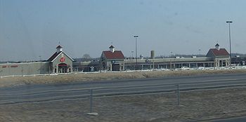
Lodi Station Outlets is located in Lodi. It reopened on August 30, 2008 with a new renovation.
Ohio
Ohio is a Midwestern state in the United States. The 34th largest state by area in the U.S.,it is the 7th‑most populous with over 11.5 million residents, containing several major American cities and seven metropolitan areas with populations of 500,000 or more.The state's capital is Columbus...
, United States
United States
The United States of America is a federal constitutional republic comprising fifty states and a federal district...
. The population was 3,061 at the 2000 census.
History
Founded in 1811, Lodi is the oldest settlement in Medina County. It was originally called Harrisville, in honor of the family that founded it. It was later renamed to Lodi, the Indian chief who lived nearby; to prevent confusion with another village in Ohio. Ainsworth Street, part of the 'Downtown Circle', is named after Chief Lodi's Daughter.Facts
An early pioneer named Redfield (after whom Redfield Street is named) sculpted the modern route to Medina through trees. It was later deemed too curvy, so the first governmental road through the region was straightened. In later years, this road became U.S. Route 42U.S. Route 42
U.S. Route 42 is an east–west United States highway that runs northeast-southwest for 355 miles from Cleveland, Ohio to Louisville, Kentucky. The route has several names including Pearl Road from Cleveland to Medina in Northeast Ohio, the Cincinnati and Lebanon Pike in southwestern Ohio and...
.
Lodi is the western endpoint of Interstate 76
Interstate 76 (east)
Interstate 76 is an Interstate Highway in the United States, running 435 miles from an interchange with Interstate 71 west of Akron, Ohio, east to Interstate 295 near Camden, New Jersey....
, where the road terminates at its junction with Interstate 71
Interstate 71
Interstate 71 is an Interstate Highway in the Great Lakes/Midwestern and Southeastern region of the United States. Its southern terminus is at an interchange with Interstate 64 and Interstate 65 in Louisville, Kentucky. Its northern terminus is at an interchange with Interstate 90 in Cleveland,...
.
Lodi hosts the annual Sweet Corn Festival in the middle of July. This three-day-long event begins with a large parade through the town square. Other attractions include fair food, amusement rides, and a popular tug-of-war.
Geography
Lodi is located at 41°1′59"N 82°0′42"W (41.033059, -82.011774), along the East Fork of the Black RiverBlack River (Ohio)
The Black River is a tributary of Lake Erie, about 12 mi long, in northern Ohio in the United States. Via Lake Erie, the Niagara River and Lake Ontario, it is part of the watershed of the St. Lawrence River, which flows to the Atlantic Ocean...
.
According to the United States Census Bureau
United States Census Bureau
The United States Census Bureau is the government agency that is responsible for the United States Census. It also gathers other national demographic and economic data...
, the village has a total area of 2.1 square miles (5.4 km²), of which 2.1 square miles (5.4 km²) is land and 0.47% is water.
The East Fork of the Black River enters the village from the north and turns back north to empty into Lake Erie. This happens because Lodi is on the north-south continental divide. Rain water runs off in either a northernly direction to Lake Erie or a southernly direction to the Ohio River.
Demographics
As of the censusCensus
A census is the procedure of systematically acquiring and recording information about the members of a given population. It is a regularly occurring and official count of a particular population. The term is used mostly in connection with national population and housing censuses; other common...
of 2000, there were 3,061 people, 1,274 households, and 789 families residing in the village. The population density
Population density
Population density is a measurement of population per unit area or unit volume. It is frequently applied to living organisms, and particularly to humans...
was 1,444.5 people per square mile (557.5/km²). There were 1,341 housing units at an average density of 632.8 per square mile (244.2/km²). The racial makeup of the village was 98.50% White, 0.03% African American, 0.36% Native American, 0.16% Asian, 0.07% from other races
Race (United States Census)
Race and ethnicity in the United States Census, as defined by the Federal Office of Management and Budget and the United States Census Bureau, are self-identification data items in which residents choose the race or races with which they most closely identify, and indicate whether or not they are...
, and 0.88% from two or more races. Hispanic or Latino of any race were 0.49% of the population.
There were 1,274 households out of which 30.4% had children under the age of 18 living with them, 47.2% were married couples
Marriage
Marriage is a social union or legal contract between people that creates kinship. It is an institution in which interpersonal relationships, usually intimate and sexual, are acknowledged in a variety of ways, depending on the culture or subculture in which it is found...
living together, 11.7% had a female householder with no husband present, and 38.0% were non-families. 32.5% of all households were made up of individuals and 13.4% had someone living alone who was 65 years of age or older. The average household size was 2.39 and the average family size was 3.05.
In the village the population was spread out with 25.6% under the age of 18, 8.0% from 18 to 24, 29.7% from 25 to 44, 22.1% from 45 to 64, and 14.6% who were 65 years of age or older. The median age was 36 years. For every 100 females there were 89.8 males. For every 100 females age 18 and over, there were 87.1 males.
The median income for a household in the village was $32,679, and the median income for a family was $43,333. Males had a median income of $32,882 versus $21,014 for females. The per capita income
Per capita income
Per capita income or income per person is a measure of mean income within an economic aggregate, such as a country or city. It is calculated by taking a measure of all sources of income in the aggregate and dividing it by the total population...
for the village was $16,512. About 8.3% of families and 10.1% of the population were below the poverty line, including 18.5% of those under age 18 and 5.0% of those age 65 or over.
Education
Lodi Primary School serves preschoolers, kindergarteners, and first and second graders. Grades three and four are sent to Seville Intermediate School, and fifth and sixth graders attend Westfield Upper Elementary. The communities of Chatham, LafayetteLafayette, Ohio
Lafayette is a village in Allen County, Ohio, United States with a population of 304 as of the 2000 U.S. census. It is included in the Lima, Ohio Metropolitan Statistical Area.-Geography:Lafayette is located at ....
, Westfield Center
Westfield Center, Ohio
Westfield Center is a village in Medina County, Ohio, United States. The population was 1,054 at the 2000 census. It was founded in 1826. When it was given a Post Office, the name "Le Roy" was assigned. The two names were used interchangeably until it was incorporated in 1914 as Le Roy, Ohio. In...
, Seville
Seville, Ohio
Seville is a village in Medina County, Ohio, United States. The population was 2,160 at the 2000 census.-Geography:Seville is located at .According to the United States Census Bureau, the village has a total area of , all land....
, and Lodi combine together to form Cloverleaf Middle School and Cloverleaf High School.
Economic
Lodi Station Outlets is located in Lodi. It reopened on August 30, 2008 with a new renovation.