

Little Cottonwood Creek
Encyclopedia
Little Cottonwood Creek is one of the principal streams entering Salt Lake Valley
from the east rises near the summit of the Wasatch Mountains a short distance south of the ski resort town of Alta
and flows in a westerly direction through Little Cottonwood Canyon
until it emerges into Salt Lake Valley
about eleven miles from its source thence its course is north westerly through Sandy
, Midvale
and Murray, Utah
until it empties into the Jordan River
about six miles south of Salt Lake City. Its whole length is nearly twenty seven miles.
The headwaters of Little Cottonwood Creek are in Little Cottonwood Canyon, a glaciated canyon in Wasatch-Cache National Forest
and the Wasatch and Uinta Mountains
eco-region. One of the main tributaries of the creek rises in Cecret Lake
a small sheet of water situated near Alta. The entire Little Cottonwood Creek drainage basin encompasses 46 mi2, ranging in altitude from about 4,490 to 11,500 ft.
Communities were founded around the creek soon after pioneer settlement of Salt Lake Valley in 1847 and supported agricultural activities. Following the discovery of gold, silver, copper, and lead in nearby canyons in the 1870s, ore-refining activities brought an influx of people to these communities. During the mid- to late 1900s, residential land use replaced agriculture as the dominant land-use type in the lower Little Cottonwood Creek drainage basin as the population of Salt Lake Valley expanded.
Land cover upstream from the mouth of Little Cottonwood Canyon is 60 percent forest land and 33 percent rangeland. The watershed in Little Cottonwood Canyon is protected as a drinking water source but receives extensive recreational use. The urbanized part of the Little Cottonwood Creek drainage basin includes that part from the mouth of Little Cottonwood Canyon to the confluence with the Jordan River. The stream provides electrical power generation for Murray City.
The first legitimate mining operation in Little Cottonwood Canyon was established in 1865. The ore deposits in Little Cottonwood Canyon yielded principally silver
and lead
with some copper
, gold
, and zinc
. These ore deposits were formed mainly in shale
, limestone
, and dolomite
. Galena
or lead sulfide was the common primary lead mineral of the area. Argentite
was found in most of the primary ores and was probably an abundant primary silver mineral. Ore production varied with time because of the nature of the deposits and the scattered control of holdings. The 1870s were especially productive, when rich deposits were mined. A number of smelters operated along Little Cottonwood Creek during the 1870s. Smelting operations produced a variety of by-products that included arsenic
, matte
, arsenical speiss, and slag
.
Past mining activities and ore-smelting operations continue to influence the water chemistry of the stream. Mine and smelter tailings in the Little Cottonwood Creek drainage basin can contribute trace metals to the stream. Metals from fluvial
tailings
deposits in the stream can be re-suspended and dissolved in the stream. Currently, the greatest threat to the streams ecosystem
is pesticides from residential run-off.
 The hydrology of Little Cottonwood Creek is typical of that of many urban streams along the Wasatch Front
and in the Intermountain West
. A system of diversions for withdrawal of irrigation water began to be developed on many Wasatch Front streams soon after settlers arrived in Salt Lake Valley in 1847. As the population of the Wasatch Front increased, more of the water in valley streams was needed for drinking and domestic purposes. To meet domestic needs, water is withdrawn from several Wasatch Front streams, including Little Cottonwood Creek, as they emerge from headwater canyons and enter Salt Lake Valley. The water needs of irrigators downstream from the canyon mouths are satisfied with water diverted out of the Jordan River and transported across the valley in a system of canals. Some of the water from the Jordan River is imported to the urbanized reach of Little Cottonwood Creek.
The flood stage for the urban waterways is 5.7 feet. Notable flooding is rare, with significant flooding in 1983 and as recently as the summer of 2010, when the waterline was 6.3 feet above bank level.
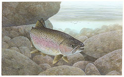
stock the creek with 1000 trout yearly. The trout are primarily rainbow
and cutthroat trout
. As the higher elevations of the creek still are affected by early mining operations there is little carry over from each year’s stocking.
Salt Lake Valley
Salt Lake Valley is a valley in Salt Lake County in the north-central portion of the U.S. state of Utah. It contains Salt Lake City and many of its suburbs, notably West Valley City, Murray, Sandy, and West Jordan; its total population is 1,029,655 as of 2010...
from the east rises near the summit of the Wasatch Mountains a short distance south of the ski resort town of Alta
Alta, Utah
Alta is a town in Salt Lake County, Utah, United States. It is part of the Salt Lake City, Utah Metropolitan Statistical Area. The population was 370 at the 2000 census, a slight decrease from the 1990 figure of 397....
and flows in a westerly direction through Little Cottonwood Canyon
Little Cottonwood Canyon
Little Cottonwood Canyon lies within the Wasatch-Cache National Forest along the eastern side of the Salt Lake Valley, roughly 15 miles from Salt Lake City, Utah. The canyon is part of Granite, a CDP and “Community Council” designated by Salt Lake County. The canyon is a glacial trough , carved by...
until it emerges into Salt Lake Valley
Salt Lake Valley
Salt Lake Valley is a valley in Salt Lake County in the north-central portion of the U.S. state of Utah. It contains Salt Lake City and many of its suburbs, notably West Valley City, Murray, Sandy, and West Jordan; its total population is 1,029,655 as of 2010...
about eleven miles from its source thence its course is north westerly through Sandy
Sandy, Utah
Sandy is a city in Salt Lake County, Utah, United States. It is a suburb of Salt Lake City. The population was 87,461 at the 2010 census, making it the sixth-largest city in Utah....
, Midvale
Midvale, Utah
Midvale is a city in Salt Lake County, Utah, United States. It is part of the Salt Lake City, Utah Metropolitan Statistical Area. The population was 27,029 at the 2000 census.-Geography:Midvale is located at ....
and Murray, Utah
Murray, Utah
Murray is a city situated on the Wasatch Front in the core of Salt Lake Valley in the U.S. state of Utah. Named for territorial governor Eli Murray, it is the state's fourteenth largest city. According to the 2010 census, Murray has approximately 46,746 residents.Murray is close to Salt Lake City,...
until it empties into the Jordan River
Jordan River (Utah)
The Jordan River in the U.S. state of Utah is a river about long. Regulated by pumps at its headwaters at Utah Lake, it flows northward through the Salt Lake Valley and empties into the Great Salt Lake. Four of Utah's five largest cities—Salt Lake City, West Valley City, West Jordan and...
about six miles south of Salt Lake City. Its whole length is nearly twenty seven miles.
The headwaters of Little Cottonwood Creek are in Little Cottonwood Canyon, a glaciated canyon in Wasatch-Cache National Forest
Wasatch-Cache National Forest
Uinta-Wasatch-Cache National Forest is a United States National Forest located primarily in northern Utah , with smaller parts extending into southeastern Idaho and southwestern Wyoming . The name is from the Ute word Wasatch for a low place in high mountains, and the French word Cache meaning to...
and the Wasatch and Uinta Mountains
Uinta Mountains
The Uinta Mountains are a high chain of mountains in northeastern Utah and extreme northwestern Colorado in the United States. A subrange of the Rocky Mountains, they are unusual for being the highest range in the contiguous United States running east to west, and lie approximately east of Salt...
eco-region. One of the main tributaries of the creek rises in Cecret Lake
Cecret Lake
Cecret Lake is a small alpine lake in Albion Basin near Alta, Utah. This area is also part of the Wasatch National Forest. Cecret Lake is also a protected watershed for Salt Lake City, Utah. It is not known why the name was spelled with a C instead of an S...
a small sheet of water situated near Alta. The entire Little Cottonwood Creek drainage basin encompasses 46 mi2, ranging in altitude from about 4,490 to 11,500 ft.
Communities were founded around the creek soon after pioneer settlement of Salt Lake Valley in 1847 and supported agricultural activities. Following the discovery of gold, silver, copper, and lead in nearby canyons in the 1870s, ore-refining activities brought an influx of people to these communities. During the mid- to late 1900s, residential land use replaced agriculture as the dominant land-use type in the lower Little Cottonwood Creek drainage basin as the population of Salt Lake Valley expanded.
Land cover upstream from the mouth of Little Cottonwood Canyon is 60 percent forest land and 33 percent rangeland. The watershed in Little Cottonwood Canyon is protected as a drinking water source but receives extensive recreational use. The urbanized part of the Little Cottonwood Creek drainage basin includes that part from the mouth of Little Cottonwood Canyon to the confluence with the Jordan River. The stream provides electrical power generation for Murray City.
The first legitimate mining operation in Little Cottonwood Canyon was established in 1865. The ore deposits in Little Cottonwood Canyon yielded principally silver
Silver
Silver is a metallic chemical element with the chemical symbol Ag and atomic number 47. A soft, white, lustrous transition metal, it has the highest electrical conductivity of any element and the highest thermal conductivity of any metal...
and lead
Lead
Lead is a main-group element in the carbon group with the symbol Pb and atomic number 82. Lead is a soft, malleable poor metal. It is also counted as one of the heavy metals. Metallic lead has a bluish-white color after being freshly cut, but it soon tarnishes to a dull grayish color when exposed...
with some copper
Copper
Copper is a chemical element with the symbol Cu and atomic number 29. It is a ductile metal with very high thermal and electrical conductivity. Pure copper is soft and malleable; an exposed surface has a reddish-orange tarnish...
, gold
Gold
Gold is a chemical element with the symbol Au and an atomic number of 79. Gold is a dense, soft, shiny, malleable and ductile metal. Pure gold has a bright yellow color and luster traditionally considered attractive, which it maintains without oxidizing in air or water. Chemically, gold is a...
, and zinc
Zinc
Zinc , or spelter , is a metallic chemical element; it has the symbol Zn and atomic number 30. It is the first element in group 12 of the periodic table. Zinc is, in some respects, chemically similar to magnesium, because its ion is of similar size and its only common oxidation state is +2...
. These ore deposits were formed mainly in shale
Shale
Shale is a fine-grained, clastic sedimentary rock composed of mud that is a mix of flakes of clay minerals and tiny fragments of other minerals, especially quartz and calcite. The ratio of clay to other minerals is variable. Shale is characterized by breaks along thin laminae or parallel layering...
, limestone
Limestone
Limestone is a sedimentary rock composed largely of the minerals calcite and aragonite, which are different crystal forms of calcium carbonate . Many limestones are composed from skeletal fragments of marine organisms such as coral or foraminifera....
, and dolomite
Dolomite
Dolomite is a carbonate mineral composed of calcium magnesium carbonate CaMg2. The term is also used to describe the sedimentary carbonate rock dolostone....
. Galena
Galena
Galena is the natural mineral form of lead sulfide. It is the most important lead ore mineral.Galena is one of the most abundant and widely distributed sulfide minerals. It crystallizes in the cubic crystal system often showing octahedral forms...
or lead sulfide was the common primary lead mineral of the area. Argentite
Argentite
Argentite was primarily treated as a mineral belonging to the galena group, cubic silver sulfide , occasionally found as uneven cubes and octahedra, but more often as dendritic or earthy masses, with a blackish lead-grey color and metallic lustre. All these forms are structurally not argentite, but...
was found in most of the primary ores and was probably an abundant primary silver mineral. Ore production varied with time because of the nature of the deposits and the scattered control of holdings. The 1870s were especially productive, when rich deposits were mined. A number of smelters operated along Little Cottonwood Creek during the 1870s. Smelting operations produced a variety of by-products that included arsenic
Arsenic
Arsenic is a chemical element with the symbol As, atomic number 33 and relative atomic mass 74.92. Arsenic occurs in many minerals, usually in conjunction with sulfur and metals, and also as a pure elemental crystal. It was first documented by Albertus Magnus in 1250.Arsenic is a metalloid...
, matte
Matte (metallurgy)
Matte is a term used in the field of pyrometallurgy given to the molten metal sulfide phases typically formed during smelting of copper, nickel, and other base metals. Typically, a matte is the phase in which the principal metal being extracted is recovered prior to a final reduction process to...
, arsenical speiss, and slag
Slag
Slag is a partially vitreous by-product of smelting ore to separate the metal fraction from the unwanted fraction. It can usually be considered to be a mixture of metal oxides and silicon dioxide. However, slags can contain metal sulfides and metal atoms in the elemental form...
.
Past mining activities and ore-smelting operations continue to influence the water chemistry of the stream. Mine and smelter tailings in the Little Cottonwood Creek drainage basin can contribute trace metals to the stream. Metals from fluvial
Fluvial
Fluvial is used in geography and Earth science to refer to the processes associated with rivers and streams and the deposits and landforms created by them...
tailings
Tailings
Tailings, also called mine dumps, slimes, tails, leach residue, or slickens, are the materials left over after the process of separating the valuable fraction from the uneconomic fraction of an ore...
deposits in the stream can be re-suspended and dissolved in the stream. Currently, the greatest threat to the streams ecosystem
Ecosystem
An ecosystem is a biological environment consisting of all the organisms living in a particular area, as well as all the nonliving , physical components of the environment with which the organisms interact, such as air, soil, water and sunlight....
is pesticides from residential run-off.
Hydrology
The hydrology of the urbanized reach of Little Cottonwood Creek is highly variable and complex because of the canals and diversion structures utilized by different water users. Source water for the urban reach of Little Cottonwood Creek varies spatially and seasonally. Sources include snowmelt, storm water, ground water, irrigation return, and water imported from the Jordan River. The effect that each of these sources has on stream quality varies seasonally and with stream flow. About 85 percent of the runoff at the mouth of Little Cottonwood Creek was from snowmelt.Wasatch Front
The Wasatch Front is a metropolitan region in the north-central part of the U.S. state of Utah. It consists of a chain of cities and towns stretched along the Wasatch Range from approximately Santaquin in the south to Brigham City in the north...
and in the Intermountain West
Intermountain West
The Intermountain West is a region of North America lying between the Rocky Mountains to the east and the Cascades and Sierra Nevada to the west. It is also called the Intermountain Region.- Topography :...
. A system of diversions for withdrawal of irrigation water began to be developed on many Wasatch Front streams soon after settlers arrived in Salt Lake Valley in 1847. As the population of the Wasatch Front increased, more of the water in valley streams was needed for drinking and domestic purposes. To meet domestic needs, water is withdrawn from several Wasatch Front streams, including Little Cottonwood Creek, as they emerge from headwater canyons and enter Salt Lake Valley. The water needs of irrigators downstream from the canyon mouths are satisfied with water diverted out of the Jordan River and transported across the valley in a system of canals. Some of the water from the Jordan River is imported to the urbanized reach of Little Cottonwood Creek.
The flood stage for the urban waterways is 5.7 feet. Notable flooding is rare, with significant flooding in 1983 and as recently as the summer of 2010, when the waterline was 6.3 feet above bank level.
Fauna
The Utah Division of Wildlife ResourcesUtah Division of Wildlife Resources
The Utah Division of Wildlife Resources is part of the Utah Department of Natural Resources for the state of Utah in the United States. The mission of the Division of Wildlife Resources is to serve the people of Utah as trustee and guardian of the state's wildlife, and to ensure its future and...
stock the creek with 1000 trout yearly. The trout are primarily rainbow
Rainbow trout
The rainbow trout is a species of salmonid native to tributaries of the Pacific Ocean in Asia and North America. The steelhead is a sea run rainbow trout usually returning to freshwater to spawn after 2 to 3 years at sea. In other words, rainbow trout and steelhead trout are the same species....
and cutthroat trout
Cutthroat trout
The cutthroat trout is a species of freshwater fish in the salmon family of order Salmoniformes. It is one of the many fish species colloquially known as trout...
. As the higher elevations of the creek still are affected by early mining operations there is little carry over from each year’s stocking.