
Litchfield, Quebec
Encyclopedia
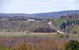
Litchfield is a municipality in the Outaouais region, part of the Pontiac Regional County Municipality, Quebec
, Canada. It is located on the shores of the eastern channel of the Ottawa River
at Calumet Island.
Its settlements include Vinton (once known as St-Elizabeth of Franktown) and Goldwin. Notable lakes include Litchfield, Leslie, and Ours (Bear) Lakes.
, an English town in Staffordshire
, north of Birmingham. On November 20, 1846, the township was incorporated with Alfred Lancaster as its first mayor. It was abolished the next year and became part of the Ottawa County Municipality. It was reestablished in 1855.
In 1863, the Municipality of Portage-du-Fort
Village separated from Litchfield's territory , followed by Bryson in 1873, and by Campbell's Bay
in 1904. Because Bryson was located in the narrowest part of the municipality, between L'Île-du-Grand-Calumet and Clarendon
, it separated the municipality's territory in two.
In 1964, the Pontiac County Council (now Pontiac MRC) built its headquarters in Litchfield on Quebec Route 148
at the edge of Campbell's Bay.
On November 6, 2004, the Township Municipality of Litchfield changed its status and became the Municipality of Litchfield.
Total private dwellings (excluding seasonal cottages): 183
Languages:
Pontiac Regional County Municipality, Quebec
Pontiac is a county regional municipality MRC Pontiac in the Outaouais region of Quebec, Canada. It should not be confused with the municipality of Pontiac, which is located inside the county regional municipality of Les Collines-de-l'Outaouais....
, Canada. It is located on the shores of the eastern channel of the Ottawa River
Ottawa River
The Ottawa River is a river in the Canadian provinces of Ontario and Quebec. For most of its length, it now defines the border between these two provinces.-Geography:...
at Calumet Island.
Its settlements include Vinton (once known as St-Elizabeth of Franktown) and Goldwin. Notable lakes include Litchfield, Leslie, and Ours (Bear) Lakes.
History
Litchfield Township, spelled "Licthfield" on the Gale and Duberger map of 1795, was officially created in 1834. It was probably named after LichfieldLichfield
Lichfield is a cathedral city, civil parish and district in Staffordshire, England. One of eight civil parishes with city status in England, Lichfield is situated roughly north of Birmingham...
, an English town in Staffordshire
Staffordshire
Staffordshire is a landlocked county in the West Midlands region of England. For Eurostat purposes, the county is a NUTS 3 region and is one of four counties or unitary districts that comprise the "Shropshire and Staffordshire" NUTS 2 region. Part of the National Forest lies within its borders...
, north of Birmingham. On November 20, 1846, the township was incorporated with Alfred Lancaster as its first mayor. It was abolished the next year and became part of the Ottawa County Municipality. It was reestablished in 1855.
In 1863, the Municipality of Portage-du-Fort
Portage-du-Fort, Quebec
Portage-du-Fort is a village and municipality in the Pontiac Regional County Municipality in the southwest corner of the Outaouais region of Quebec, Canada...
Village separated from Litchfield's territory , followed by Bryson in 1873, and by Campbell's Bay
Campbell's Bay, Quebec
Campbell's Bay is a village in the Pontiac Regional County Municipality in western Quebec. Its population in 2001 was 766. It is the county seat and is home to most government offices for the county, including the Sûreté du Québec, and has French and English elementary schools. Campbell's Bay is in...
in 1904. Because Bryson was located in the narrowest part of the municipality, between L'Île-du-Grand-Calumet and Clarendon
Clarendon, Quebec
Clarendon is a municipality in the Outaouais region, part of the Pontiac Regional County Municipality, Quebec, Canada. It is located on the north shore of the Ottawa River across from Horton Township in Ontario....
, it separated the municipality's territory in two.
In 1964, the Pontiac County Council (now Pontiac MRC) built its headquarters in Litchfield on Quebec Route 148
Quebec route 148
Route 148 is a major east-west highway in Quebec, Canada. It runs from Autoroute 25 in Laval in the Montreal region to the Ontario-Quebec border in L'Isle-aux-Allumettes in western Quebec. For most of its length, Route 148 follows the north shore of the Ottawa River where it acts as the principal...
at the edge of Campbell's Bay.
On November 6, 2004, the Township Municipality of Litchfield changed its status and became the Municipality of Litchfield.
Demographics
Population:- Population in 2006: 483
- Population in 2001: 509
- 2001 to 2006 population change: -5.1 %
- Population in 1996: 484
- Population in 1991: 493
Total private dwellings (excluding seasonal cottages): 183
Languages:
- English as first language: 67 %
- French as first language: 27 %
- English and French as first language: 6 %