
List of rivers of Guyana
Encyclopedia
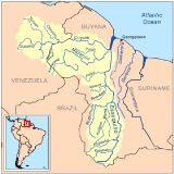
By Drainage BasinDrainage basinA drainage basin is an extent or an area of land where surface water from rain and melting snow or ice converges to a single point, usually the exit of the basin, where the waters join another waterbody, such as a river, lake, reservoir, estuary, wetland, sea, or ocean...
This list is arranged by drainage basin, with respective tributaries indented under each larger stream's name.Atlantic OceanAtlantic OceanThe Atlantic Ocean is the second-largest of the world's oceanic divisions. With a total area of about , it covers approximately 20% of the Earth's surface and about 26% of its water surface area...
- Amazon River (Brazil)
- Negro River (Brazil)
- Branco River (Brazil)
- Takutu RiverTakutu RiverThe Takutu River is a river in the Upper Takutu-Upper Essequibo Region of Guyana. It forms part of the boundary with Brazil, and is a tributary of the Branco River...
- Ireng RiverIreng RiverThe Ireng River forms part of Guyana's western border with Brazil. It flows through the valleys of the Pakaraima Mountains for most of its length. It is the only major river in Guyana which flows from North to South. It is one of the northernmost tributaries of the Amazon river system.It is...
- Ireng River
- Takutu River
- Branco River (Brazil)
- Negro River (Brazil)
- Courentyne River
- New RiverNew River (Guyana)The New River is a river in South America. It is part of a border dispute between Suriname and Guyana-References:* Rand McNally, The New International Atlas, 1993....
- New River
Ask Yuh Moda River
-
- Kutari River
- Coeroeni RiverCoeroeni RiverThe Coeroeni River is a river in South America. It arises in the northwestern part of Pará, Brazil, and flows northward remaining in Brazil for only a few kilometres. The Coeroeni goes on to form the southern half of the international boundary between Guyana and Suriname. It eventually flows into...
- Berbice RiverBerbice RiverThe Berbice River, located in eastern Guyana, rises in the highlands of the Rupununi region. The Berbice flows northward for 370 miles through dense forests to the coastal plain...
- Canje RiverCanje RiverThe Canje River, located in northeastern Guyana, is the main tributary of the Berbice River. It runs roughly parallel to the Atlantic Ocean coast....
- Canje River
- Abary RiverAbary RiverThe Abary River is a small river in northern Guyana that drains into the Atlantic Ocean.Historic Amerindian settlements existed at Tiger Island, Taurakuli and Doctor Ho Landing...
- Mahaicony RiverMahaicony RiverThe Mahaicony River is a small river in northern Guyana that drains into the Atlantic Ocean. Mahaicony village is found at the mouth of the river.Farming is the predominant human use of the lower reaches of the river....
- Mahaica RiverMahaica RiverThe Mahaica River is a small river in northern Guyana that drains into the Atlantic Ocean. The village of Mahaica is found at its mouth.Farming is the predominant human use of the lower reaches of the river....
- Demerara RiverDemerara RiverThe Demerara River is a river in eastern Guyana that rises in the central rainforests of the country and flows to the north for 346 kilometres until it reaches the Atlantic Ocean. Georgetown, Guyana's largest seaport and capital, is situated on the east bank of the river's mouth. The Demerara's...
- Haiama RiverHaiama RiverThe Haiama River is a west bank tributary of the Demerara River in northern Guyana. It enters the Demerara River 280 yards from the mouth....
- Haianari CreekHaianari CreekHaianari Creek is a west bank tributary of the Demerara River in northern Guyana. It enters the Demerara River 90 miles upstream of the Demerara's mouth....
- Haiakwa CreekHaiakwa CreekHaiakwa Creek is an east bank tributary of the Demerara River in northern Guyana. It enters the Demerara River 27 miles upstream of Linden....
- Kuruabaru RiverKuruabaru RiverThe Kuruabaru River is an east bank tributary of the Demerara River in northern Guyana. It enters the Demerara River 140 miles from its mouth....
- Haiama River
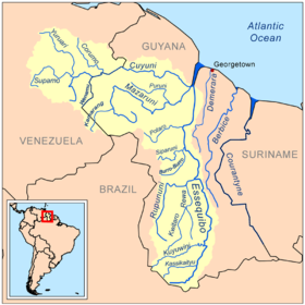
- Essequibo RiverEssequibo RiverThe Esequibo River is the largest river in Guyana, and the largest river between the Orinoco and Amazon. Rising in the Acarai Mountains near the Brazil-Guyana border, the Essequibo flows to the north for 1,010 km through forest and savanna into the Atlantic Ocean.-Geography:There are countless...
- Mazaruni RiverMazaruni RiverThe Mazaruni River is a river in northern Guyana, running from its source in the remote western forests of the Pakaraima Mountains to its confluence with the Cuyuni River near Bartica...
- Kamarang River
- Issineru RiverIssineru River-References:*Rand McNally, The New International Atlas, 1993....
- Meamu RiverMeamu River-References:*Rand McNally, The New International Atlas, 1993....
- Kurupung RiverKurupung River-References:*Rand McNally, The New International Atlas, 1993....
- Eping RiverEping River-References:*Rand McNally, The New International Atlas, 1993....
- Merume RiverMerume River-References:*Rand McNally, The New International Atlas, 1993....
- Puruni RiverPuruni River-References:* Rand McNally, The New International Atlas, 1993....
- Cuyuni RiverCuyuni RiverThe Cuyuni River is a South American river and a tributary of the Essequibo River. It rises in the Guiana Highlands of Venezuela where it descends northward to El Dorado, and turns eastward to meander through the tropical rain forests of Guayana Esequiba...
- Wenamu RiverWenamu RiverWenamu River is a river in South America. It forms a portion of the international boundary betrween Venezuela and Guyana. It is part of the Essequibo River basin.-References:*Rand McNally, The New International Atlas, 1993....
- Ekareku River
- Akaiwang River
- Oko RiverOko River-References:*Rand McNally, The New International Atlas, 1993....
- Wenamu River
- Potaro RiverPotaro RiverThe Potaro River is a river in Guyana in northern South America.The source of the Potaro River is in the Mount Ayanganna area of the Pakaraima Mountains in the North Rupununi Savannahs...
- Konawaruk RiverKonawaruk RiverThe Konawaruk River is a river in western Guyana. It is a tributary of the Essequibo River, joining it just south of the Potaro River mouth at ....
- Siparuni RiverSiparuni RiverThe Siparuni River is a river in the Potaro-Siparuni Region of Guyana. It is a tributary of the Essequibo River. Tributaries of the Siparuni River include the Takutu River , Burro-Burro River, Tipuru River and Levai Creek....
- Burro-Burro RiverBurro-Burro River-References:* Rand McNally, The New International Atlas, 1993.*...
- Burro-Burro River
- Rupununi River
- Rewa RiverRewa River (Guyana)-References:* Rand McNally, The New International Atlas, 1993....
- Rewa River
- Kuyuwini RiverKuyuwini River-References:* Rand McNally, The New International Atlas, 1993....
- Kassikaityu RiverKassikaityu River-References:* Rand McNally, The New International Atlas, 1993....
- Mazaruni River
- Pomeroon RiverPomeroon RiverThe Pomeroon River is located in Guyana, South America, situated between the Orinoco River and the Essequibo River. A colony was started by the Dutch on the river in the 17th century, which was later destroyed by French privateers.- See also :...
- Wakapau RiverWakapau RiverThe Wakapau River is a tributary of the Pomeroon River, on its west bank. The village of Wakapau is found on the Wakapau River, 3 km from its mouth....
- Wakapau River
- Moruka RiverMoruka RiverThe Moruka River is a river in the Barima-Waini region of northern Guyana.Settlements along the river include Santa Rosa, Kamwatta and Asakata....
- Waini RiverWaini RiverThe Waini River is a river in the Barima-Waini region of northern Guyana. It flows into the Atlantic Ocean near the border with Venezuela. The upper portion of the river flows through the Guianian moist forests, while the lower Waini river flows through the eastern extent of the vast Orinoco Delta...
- Barama RiverBarama River-References:* Rand McNally, The New International Atlas, 1993.*...
- Barama River
- Orinoco River (Venezuela)
- Barima RiverBarima RiverThe Barima River is a tributary of the Orinoco River, entering 4 miles from the Atlantic Ocean. It originates in Guyana, flowing for approximately 210 miles before entering Venezuela about 50 miles from its mouth....
- Kaituma RiverKaituma River-References:* Rand McNally, The New International Atlas, 1993....
- Kaituma River
- Amacuro RiverAmacuro RiverAmacuro River is a river in South America. It forms part of the northern section of the international boundary between Venezuela and Guyana. It is part of the Orinoco River basin.-References:*Rand McNally, The New International Atlas, 1993....
(Amakura River)
- Barima River