
List of islands in the Houtman Abrolhos
Encyclopedia

Houtman Abrolhos
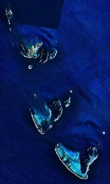
The Houtman Abrolhos is a chain of 122 islands, and associated coral reefs, in the Indian Ocean off the west coast of Australia. Nominally located at , it lies about eighty kilometres west of Geraldton, Western Australia...
, an island chain off the west coast of Australia
Australia
Australia , officially the Commonwealth of Australia, is a country in the Southern Hemisphere comprising the mainland of the Australian continent, the island of Tasmania, and numerous smaller islands in the Indian and Pacific Oceans. It is the world's sixth-largest country by total area...
. It is complete with respect to the 1996 Gazetteer of Australia
Gazetteer of Australia
The Gazetteer of Australia is a register of the location and spelling of geographical names across Australia. It is compiled by the Intergovernmental Committee on Surveying and Mapping and derived from state, territory, and Australian government agencies....
. It is widely reported that the Houtman Abrolhos contains 122 islands, but only the 93 islands had gazetted names in 1996. In the gazetteer of 2011 Hartley Island appears no more, but Barge Rock, Second Sister and Shag Rock appear, which raises the number of gazetted names to 96 (30 in the Wallabi Group, 38 in the Pelsaert Group and 28 in the Easter Group).
In addition to the gazetted islands, six island groups have been gazetted. The three main groups are the Wallabi Group
Wallabi Group
The Wallabi Group is the northern-most group of islands in the Houtman Abrolhos. Nominally located at , it is 58 kilometres from the Australian mainland, and about 9 kilometres from the Easter Group....
, the Easter Group
Easter Group
The Easter Group is the central of three groups of islands that make up the Houtman Abrolhos island chain. Nominally located at , it is about 20 kilometres by 12 kilometres, and consists of a number of islands including Rat Island, Wooded Island, Morley Island, Suomi Island and Alexander Island....
and the Pelsaert Group
Pelsaert Group
The Pelsaert Group is the southernmost of the three groups of islands that make up the Houtman Abrolhos island chain. Nominally located at , it consists of a number of islands, the largest of which are Gun Island, Middle Island, and Pelsaert Island. The group is named after a Dutch "opperkoopman"...
. In addition, the Easter Group contains a group known as the Eastern Islands, and the Pelsaert group contains groups known as the Mangrove Group and the Numbered Islands.
The Inventory of the Land Conservation Values of the Houtman Abrolhos mentions many more unofficially named islets, 16 in the Wallabi Group, 26 in the Eastern Group and 15 in the Pelsaert Group, plus the subgroups of the Jackson Islets (7 islets without individual names or numbers) and The Coral Patches (13 islets without individual names or numbers), also in the Pelsaert Group.
This makes for a total of 173 known islands, islets and above-water rocks with land area in the Houtman Abrolhos.
List of islands in the Houtman Abrolhos
| Name | Area m² | Coordinates | Group, Subgroup |
|---|---|---|---|
| 1 Island | 17661 | 28°54′34"S 113°52′55"E | Pelsaert Group, Numbered Islands |
| 2 Island | 3207 | 28°54′34"S 113°52′42"E | Pelsaert Group, Numbered Islands |
| 3 Island | 17166 | 28°54′24"S 113°52′16"E | Pelsaert Group, Numbered Islands |
| 7 Island | 4419 | 28°54′22"S 113°51′21"E | Pelsaert Group, Numbered Islands |
| 8 Island | 6154 | 28°53′56"S 113°51′36"E | Pelsaert Group, Numbered Islands |
| Akerstrom Island | 12073 | 28°28′30"S 113°41′51"E | Wallabi Group |
| Alcatraz Island | 716. | 28°27′43"S 113°43′18"E | Wallabi Group |
| Alexander Island Alexander Island (Houtman Abrolhos) Alexander Island is one of the five largest islands in the Easter Group of the Houtman Abrolhos. It is nominally located at The island is part of the Houtman Abrolhos Important Bird Area, identified as such by BirdLife International because of its importance for supporting large numbers of... |
128610 | 28°40′26"S 113°49′44"E | Easter Group |
| Arthur Island | ... | 28°53′55"S 114°0′12"E | Pelsaert Group |
| Barge Rock | ... | 28°27′2"S 113°43′17"E | Wallabi Group |
| Basile Island | ... | 28°52′33"S 113°57′38"E | Pelsaert Group |
| Beacon Island | ... | 28°28′35"S 113°47′2"E | Wallabi Group |
| Burnett Island | ... | 28°52′22"S 113°57′47"E | Pelsaert Group |
| Burton Island | ... | 28°51′59"S 113°59′6"E | Pelsaert Group |
| Bushby Island | ... | 28°43′25"S 113°47′7"E | Easter Group |
| Bynoe Island | ... | 28°39′54"S 113°52′31"E | Easter Group, Eastern Islands |
| Campbell Island | ... | 28°41′44"S 113°50′5"E | Easter Group |
| Coronation Island | ... | 28°52′14"S 113°59′7"E | Pelsaert Group |
| Crake Island | ... | 28°44′31"S 113°48′57"E | Easter Group |
| Dakin Island | ... | 28°28′37"S 113°48′25"E | Wallabi Group |
| Davis Island (5 Island) | ... | 28°54′53"S 113°52′33"E | Pelsaert Group, Numbered Islands |
| Dicks Island | ... | 28°29′51"S 113°45′56"E | Wallabi Group |
| Disappearing Island | ... | 28°47′3"S 113°44′23"E | Easter Group |
| Diver Island | ... | 28°52′2"S 113°58′20"E | Pelsaert Group |
| Dry Island | ... | 28°44′22"S 113°46′43"E | Easter Group |
| East Wallabi Island East Wallabi Island East Wallabi Island is an island in the Wallabi Group of the Houtman Abrolhos, located in the Indian Ocean off the west coast of mainland Australia.-History:East Wallabi Island played an important role in the story of the Batavia shipwreck and massacre... |
... | 28°26′23"S 113°43′33"E | Wallabi Group |
| Eastern Island | ... | 28°27′55"S 113°48′42"E | Wallabi Group |
| Eight Island | ... | 28°53′56"S 113°51′36"E | Pelsaert Group |
| Far Island | ... | 28°27′40"S 113°48′19"E | Wallabi Group |
| First Sister | ... | 28°28′39"S 113°44′33"E | Wallabi Group |
| Foale Island | ... | 28°52′45"S 114°0′20"E | Pelsaert Group |
| Gaze Island | ... | 28°51′50"S 113°59′25"E | Pelsaert Group |
| Gibson Island | ... | 28°41′13"S 113°49′40"E | Easter Group |
| Gilbert Island | ... | 28°40′5"S 113°49′34"E | Easter Group |
| Gregory Island | ... | 28°53′55"S 114°0′19"E | Pelsaert Group |
| Gun Island Gun Island Gun Island is one of the larger islands in the Pelsaert Group of the Houtman Abrolhos. It is nominally located at , about 4 km north and east of Half Moon Reef and is a flat limestone outcrop of about by in size... |
... | 28°53′17"S 113°51′26"E | Pelsaert Group |
| Hall Island | ... | 28°28′18"S 113°48′36"E | Wallabi Group |
| Helms Island | ... | 28°40′10"S 113°51′38"E | Easter Group, Eastern Islands |
| Hummock Island | ... | 28°48′2"S 114°2′20"E | Pelsaert Group |
| Iris Refuge Island | ... | 28°52′48"S 114°0′16"E | Pelsaert Group |
| Jackson Island | ... | 28°52′17"S 114°0′10"E | Pelsaert Group |
| Joe Smith Island | ... | 28°40′55"S 113°51′28"E | Easter Group, Eastern Islands |
| Jon Jim Island | ... | 28°59′14"S 113°57′34"E | Pelsaert Group |
| Keru Island | ... | 28°43′34"S 113°49′57"E | Easter Group |
| Lagoon Island | ... | 28°52′22"S 113°59′39"E | Pelsaert Group |
| Leo Island | ... | 28°41′22"S 113°51′36"E | Easter Group, Eastern Islands |
| Little North Island | ... | 28°37′51"S 113°52′53"E | Easter Group, Eastern Islands |
| Little Pigeon Island | ... | 28°27′49"S 113°43′20"E | Wallabi Group |
| Little Rat Island | ... | 28°43′41"S 113°47′7"E | Easter Group |
| Little Roma Island | ... | 28°44′7"S 113°46′51"E | Easter Group |
| Long Island | ... | 28°28′20"S 113°46′21"E | Wallabi Group |
| Marinula Island | ... | 28°28′31"S 113°41′57"E | Wallabi Group |
| Middle Island | ... | 28°54′31"S 113°54′36"E | Pelsaert Group |
| Morley Island | ... | 28°44′47"S 113°48′45"E | Easter Group |
| Murray Island | ... | 28°53′53"S 113°53′47"E | Pelsaert Group |
| Newbold Island | ... | 28°52′54"S 114°0′19"E | Pelsaert Group |
| Newman Island | ... | 28°51′48"S 113°59′42"E | Pelsaert Group |
| Nook Island | ... | 28°51′58"S 113°59′57"E | Pelsaert Group |
| North Island North Island (Houtman Abrolhos) North Island is the northernmost island in the Houtman Abrolhos, a coral reef archipelago in the Indian Ocean off the coast of Mid West Western Australia. Located about 14 km from the nearest island group, it is one of the largest islands in the Houtman Abrolhos, and one of the few to support... |
... | 28°18′9"S 113°35′41"E | Wallabi Group |
| Oystercatcher Island | ... | 28°27′48"S 113°42′47"E | Wallabi Group |
| Pelican Island | ... | 28°27′36"S 113°40′34"E | Wallabi Group |
| Pelsaert Island | ... | 28°55′45"S 113°58′27"E | Pelsaert Group |
| Pigeon Island Pigeon Island (Houtman Abrolhos) Pigeon Island is a small island located need the middle of the Wallabi Group of the Houtman Abrolhos, an archipelago off the coast of Western Australia. It is almost entirely given over to Western Rock Lobster fishers' camps, and as a result is far more disturbed than most other islands in the... |
... | 28°27′18"S 113°43′34"E | Wallabi Group |
| Plover Island | ... | 28°28′5"S 113°42′43"E | Wallabi Group |
| Post Office Island | ... | 28°51′53"S 113°58′28"E | Pelsaert Group |
| Rat Island | ... | 28°42′56"S 113°47′2"E | Easter Group |
| Robertson Island | ... | 28°52′58"S 114°0′20"E | Pelsaert Group |
| Roma Island | ... | 28°43′57"S 113°47′6"E | Easter Group |
| Rotondella Island | ... | 28°52′21"S 113°59′45"E | Pelsaert Group |
| Sandy Island | ... | 28°46′31"S 113°47′8"E | Easter Group |
| Sandy Island | ... | 28°52′22"S 113°52′35"E | Pelsaert Group |
| Saville-Kent Island | ... | 28°27′56"S 113°48′27"E | Wallabi Group |
| Seagull Island | ... | 28°27′29"S 113°42′52"E | Wallabi Group |
| Seal Island | ... | 28°29′1"S 113°48′7"E | Wallabi Group |
| Second Sister | ... | 28°29′8"S 113°44′25"E | Wallabi Group |
| Serventy Island | ... | 28°40′59"S 113°49′52"E | Easter Group |
| Shag Rock Shag Rock (Houtman Abrolhos) -Geography:It is located at , about east of West Wallabi Island. Its nearest neighbour is Plover Island, about away. The island has an area of about , and a maximum elevation of . It is uninhabitated, and devoid of human infrastructure.... |
... | 28°28′32"S 113°42′43"E | Wallabi Group |
| Shearwater Island | ... | 28°43′56"S 113°49′29"E | Easter Group |
| Sid Liddon Island (6 Island) | ... | 28°54′40"S 113°51′49"E | Pelsaert Group, Numbered Islands |
| Square Island | ... | 28°54′7"S 113°56′38"E | Pelsaert Group |
| Stick Island | ... | 28°53′22"S 113°55′11"E | Pelsaert Group |
| Stokes Island | ... | 28°40′30"S 113°51′2"E | Easter Group, Eastern Islands |
| Suomi Island | ... | 28°42′45"S 113°50′17"E | Easter Group |
| Sweet Island (4 Island) | ... | 28°55′1"S 113°52′17"E | Pelsaert Group, Numbered Islands |
| Tapani Island | ... | 28°40′30"S 113°51′16"E | Easter Group, Eastern Islands |
| Tattler Island | ... | 28°28′10"S 113°42′22"E | Wallabi Group |
| Third Sister | ... | 28°29′46"S 113°44′23"E | Wallabi Group |
| Traitors Island Traitors Island Traitors Island is an uninhabited island off the western coast of Australia, near the site of the Batavia shipwreck. About 50 metres long, it is situated near Beacon Island and is part of the Wallabi Group within the Houtman Abrolhos.-History:... |
... | 28°29′6"S 113°46′57"E | Wallabi Group |
| Travia Island | ... | 28°51′52"S 113°59′12"E | Pelsaert Group |
| Turnstone Island | ... | 28°27′9"S 113°42′57"E | Wallabi Group |
| Uncle Margie Island | ... | 28°52′4"S 113°57′59"E | Pelsaert Group |
| Wann Island | ... | 28°28′19"S 113°45′45"E | Wallabi Group |
| West Wallabi Island West Wallabi Island West Wallabi Island is an island in the Wallabi Group of the Houtman Abrolhos, located in the Indian Ocean off the west coast of mainland Australia.-History:... |
... | 28°28′3"S 113°41′12"E | Wallabi Group |
| White Bank | ... | 28°42′10"S 113°46′30"E | Easter Group |
| White Island | ... | 28°40′16"S 113°52′30"E | Easter Group, Eastern Islands |
| Wooded Island | ... | 28°45′7"S 113°48′20"E | Easter Group |