

List of ghost towns in Montana
Encyclopedia
Montana
Montana is a state in the Western United States. The western third of Montana contains numerous mountain ranges. Smaller, "island ranges" are found in the central third of the state, for a total of 77 named ranges of the Rocky Mountains. This geographical fact is reflected in the state's name,...
.
A ghost town is a town or city where peoples souls are haunting others or places.. A town often becomes a ghost town because the economic activity that supported it has failed, or due to natural or human-caused disasters such as a flood, government action, uncontrolled lawlessness, or war. The term is sometimes used in a deprecated sense to include cities, towns, and neighborhoods which, while still populated, are significantly less so than in years past.
Abandoned towns
- AldridgeAldridge, MontanaAldridge is a ghost town in Park County, Montana. The town was originally called Horr from its first settlement in 1901, then Electric, and those names continued to be applied to districts of the town. Established as Aldridge in 1906, the town was located north of Gardiner...
, Park County, MontanaPark County, MontanaPark Counties in Montana and Wyoming are among the very few pairs of counties in the United States with the same name to border each other across state lines.-National protected areas:* Custer National Forest * Gallatin National Forest...
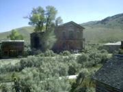
, 45°05′13"N 110°49′18"W, el. 6427 feet (1,958.9 m), - BannackBannack, MontanaBannack is a ghost town in Beaverhead County, Montana, United States, located on Grasshopper Creek, approximately upstream from where Grasshopper Creek joins with the Beaverhead River south of Dillon.-History:...
, Beaverhead County, MontanaBeaverhead County, Montana-National protected areas:* Beaverhead National Forest * Big Hole National Battlefield* Nez Perce National Historical Park * Red Rock Lakes National Wildlife Refuge-History:...
, 45°09′40"N 112°59′44"W, el. 5728 feet (1,745.9 m) - ColomaColoma, MontanaColoma is a ghost town located in the area of the Garnet Range in Missoula County, Montana. Not much is known about the settlement, which appears to have been founded in 1893. Records of the period indicate high gold mining activity from 1896 onwards, with an estimated $200,000 to $250,000 in gold...
, Missoula County, MontanaMissoula County, Montana-National protected areas:*Bitterroot National Forest *Flathead National Forest *Lolo National Forest *Rattlesnake National Recreation Area-Demographics:...
46°50′35"N 113°22′50"W, el. 5928 feet (1,806.9 m) - Rocky Point, MontanaRocky Point, Montana (Ghost Town)The Rocky Point ghost town in the Missouri Breaks of Montana is not be confused with the currently viable and modern Montana community of Rocky Point, Montana on the west shore of Flathead Lake in Lake County....
47°36′22.54"N 108°26′45.72"W
Towns with residual population
- Albion, Carter County, MontanaCarter County, Montana-Demographics:As of the census of 2000, there were 1,360 people, 543 households, and 382 families residing in the county. The population density was -Demographics:...
, 45°11′14"N 104°16′37"W, el. 3376 feet (1,029 m) - Alton
- Argo
- Barker
- Bean
- Bear Creek
- BearmouthBearmouth, MontanaBearmouth was a trading post for the placer mining camps of Beartown, Garnet and Coloma, located in the hills north of Bearmouth. A pioneer family named Lannen operated the gold exchange and ferry boat across the Clark Fork River....
, Granite County, MontanaGranite County, Montana-National protected areas:*Deerlodge National Forest *Lolo National Forest -Demographics:As of the census of 2000, there were 2,830 people, 1,200 households, and 784 families residing in the county. The population density was 2 people per square mile . There were 2,074 housing units at an average... - Bowler
- Cable
- CarterCarter, MontanaCarter is a census-designated place in Chouteau County, Montana, United States. The population was 62 at the 2000 census.-Geography:Carter is located at ....
- Castle Town, Meagher County, MontanaMeagher County, Montana-National protected areas:*Gallatin National Forest *Helena National Forest *Lewis and Clark National Forest -Demographics:As of the census of 2000, there were 1,932 people, 803 households, and 529 families residing in the county...
, 46°26′29"N 110°40′19"W, el. 5978 feet (1,822.1 m) - Coburg
- ComertownComertown, MontanaComertown is an unincorporated community in northeastern Sheridan County, Montana, United States. Founded in 1913, it was established as a station stop on the Soo Line Railroad branch line to Whitetail...
, Sheridan County, MontanaSheridan County, Montana-Demographics:As of the census of 2000, there were 4,105 people, 1,741 households, and 1,140 families residing in the county. The population density was 2.4 people per square mile . There were 2,167 housing units at an average density of 1.3 per square mile...
, 48°53′49"N 104°15′0"W, el. 2270 feet (691.9 m) - CometComet, MontanaComet is a ghost town located about twenty miles south-southwest of Helena, Montana, United States. It is reached by following High Ore Road north from Interstate 15. The remains of the town cover about thirty-five acres and consist of an ore hopper, a large ore processing building, several other...
, Jefferson County, MontanaJefferson County, Montana-National protected areas:*Deerlodge National Forest *Helena National Forest -Demographics:As of the census of 2000, there were 10,049 people, 3,747 households, and 2,847 families residing in the county. The population density was 6 people per square mile . There were 4,199 housing units at an... - Coolidge
- Corwin
- DooleyDooley, MontanaDooley is a ghost town in northeastern Sheridan County, Montana, United States. The town was established as a station stop on the Soo Line Railroad branch line to Whitetail, Montana, constructed in 1913....
, Sheridan County, MontanaSheridan County, Montana-Demographics:As of the census of 2000, there were 4,105 people, 1,741 households, and 1,140 families residing in the county. The population density was 2.4 people per square mile . There were 2,167 housing units at an average density of 1.3 per square mile... - Electric
- ElkhornElkhorn, MontanaElkhorn is a small ghost town in Jefferson County, Montana, United States, in the Elkhorn Mountains of the southwestern part of the state.-History:...
, Jefferson County, MontanaJefferson County, Montana-National protected areas:*Deerlodge National Forest *Helena National Forest -Demographics:As of the census of 2000, there were 10,049 people, 3,747 households, and 2,847 families residing in the county. The population density was 6 people per square mile . There were 4,199 housing units at an... - Ewing
- Exeter
- FoxFox, MontanaFox is an unincorporated community in Carbon County, Montana, United States. Although it is unincorporated, Fox has a post office with a ZIP code of 59070. Fox lies on U.S. Route 212 southwest of Roberts and northeast of Red Lodge.-References:...
, Carbon County, MontanaCarbon County, Montana-National protected areas:* Bighorn Canyon National Recreation Area * Custer National Forest * Gallatin National Forest -Economy:During the early history of Carbon County, coal mining was the predominant industry... - GarnetGarnet, MontanaGarnet is a ghost town in Granite County, Montana, United States. Located on the dirt Wallace Creek Road, it is an abandoned mining town from the 1860s. In First Chance Creek in western Montana, the town is at the edge of the high desert in the Front Range, but sheltered in a forest...
, Granite County, MontanaGranite County, Montana-National protected areas:*Deerlodge National Forest *Lolo National Forest -Demographics:As of the census of 2000, there were 2,830 people, 1,200 households, and 784 families residing in the county. The population density was 2 people per square mile . There were 2,074 housing units at an average... - Giltedge
- Glendale
- Gold Creek
- GraniteGranite, MontanaGranite is a ghost town in Granite County, Montana, United States, east of the town of Philipsburg. Granite thrived as a silver mining town in the 1890s, but is now completely deserted.-History:...
, Granite County, MontanaGranite County, Montana-National protected areas:*Deerlodge National Forest *Lolo National Forest -Demographics:As of the census of 2000, there were 2,830 people, 1,200 households, and 784 families residing in the county. The population density was 2 people per square mile . There were 2,074 housing units at an average... - Hassel
- HeclaHecla, MontanaHecla was a town in Beaverhead County, Montana. It has been designated as a ghost town with only a few ruined buildings remaining. It was notable at one time as the home of Blanche Lamont, who taught at Hecla's one-room schoolhouse. Lamont would become the first of two murder victims of Theodore...
, Beaverhead County, MontanaBeaverhead County, Montana-National protected areas:* Beaverhead National Forest * Big Hole National Battlefield* Nez Perce National Historical Park * Red Rock Lakes National Wildlife Refuge-History:... - Hillsboro
- Independence
- IngomarIngomar, MontanaIngomar is a small unincorporated community in northwestern Rosebud County, Montana, United States, along the route of U.S. Route 12. The town was established in 1908 as a station stop on the Chicago, Milwaukee, St. Paul and Pacific Railroad, then under construction in Montana...
, Rosebud County, MontanaRosebud County, Montana-Demographics:As of the census of 2000, there were 9,383 people, 3,307 households, and 2,417 families residing in the county. The population density was 2 people per square mile . There were 3,912 housing units at an average density of 1 per square mile... - JardineJardine, MontanaJardine is a small, unincorporated village in Park County, Montana, USA. The town lies just to the north of Gardiner on inactive travertine terraces, much like those at Mammoth Hot Springs in nearby Yellowstone National Park. The town's chief industry was a gold mine.-References:...
- Kendall
- Keystone, Mineral County, MontanaMineral County, Montana-Demographics:As of the census of 2000, there were 3,884 people, 1,584 households, and 1,067 families residing in the county. The population density was 3 people per square mile . There were 1,961 housing units at an average density of 2 per square mile...
- Kirkville
- Landusky
- Laurin
- LonetreeLonetree, MontanaLonetree is a ghost town in Chouteau County, Montana, United States. Founded around 1885, it is located at , at an altitude of 3,123 feet . For nearly thirty years it possessed a post office, which was opened under the name of Steele on March 9, 1888; its name was changed to Lonetree on...
, Chouteau County, MontanaChouteau County, Montana-National protected areas:* Lewis and Clark National Forest * Upper Missouri River Breaks National Monument -Economy:Chouteau County is the largest winter wheat producer for the state of Montana... - Maiden
- Mammoth
- MarysvilleMarysville, MontanaMarysville is a small unincorporated community in Lewis and Clark County, Montana, United States. In the 1880s and 90's it was a bustling mining town of three thousand residents, and was the center of gold mining in Montana. A few buildings remain, including a baseball field with bleachers...
- MaudlowMaudlow, MontanaMaudlow is a small unincorporated community in northern Gallatin County, Montana, United States. The town was a station stop on the transcontinental main line of the Chicago, Milwaukee, St...
- MelroseMelrose, MontanaMelrose is a neighborhood of Butte, Montana, United States, located at 45.6847ºN, 112.63ºW. Melrose lies off Interstate 15, Big Hole River Valley, and is an outfitting hub for fly fisherman using the Big Hole and Wise Rivers....
- Mondak, MontanaMondak, MontanaMondak, Montana is a ghost town in Roosevelt County, which flourished circa 1903-1919, in large measure by selling alcohol to residents of North Dakota, then a dry state....
, Roosevelt County, MontanaRoosevelt County, Montana-National protected areas:* Fort Union Trading Post National Historic Site * Medicine Lake National Wildlife Refuge -Demographics:As of the census of 2000, there were 10,620 people, 3,581 households, and 2,614 families residing in the county. The population density was 4 people per square mile... - Nevada CityNevada City, MontanaNevada City was one of the two major centers of Commerce in what was known as one of the "Richest Gold Strikes in the Rocky Mountain West", it shared that role with its sister city Virginia City. The town site is located 1½ miles west of Virginia City, Montana on Hwy 287. Today the town is managed...
- Old Chico
- Pardee, Mineral County, MontanaMineral County, Montana-Demographics:As of the census of 2000, there were 3,884 people, 1,584 households, and 1,067 families residing in the county. The population density was 3 people per square mile . There were 1,961 housing units at an average density of 2 per square mile...
- Perma
- Pioneer, Beaverhead County
- Pioneer, Powell County
- PonyPony, MontanaPony is an unincorporated community in northeastern Madison County, Montana, United States on the eastern edge of the Tobacco Root Mountains.In the late nineteenth century, Pony was a prosperous gold-mining community with at least 5,000 residents. A number of historic buildings from Pony's boom era...
- Red Bluff
- Red Lion
- Rimini
- Rockvale
- Ruby
- Ruby Gulch
- Silesia
- Silver BowSilver Bow, MontanaSilver Bow is a neighborhood in Butte, Montana, United States. It lies near the interchange of Interstate 15 and Interstate 90, near Rocker. Silver Bow is at Exit 119 off I-15, near the Port of Montana. It is well known locally as the location of the Silver Bow Twin Drive-In. Silver Bow has no...
- SixteenSixteen, MontanaSixteen is a former unincorporated community in southwestern Meagher County, Montana, United States. The town was a station stop on the transcontinental main line of the Chicago, Milwaukee, St. Paul and Pacific Railroad , and was a community center for a small number of area ranchers and ...
- Southern Cross
- Stark
- Storrs
- SumatraSumatra, MontanaSumatra is a small, unincorporated village in far northwestern Rosebud County, Montana, USA, along the route of U.S. Highway 12. The town was established in 1908 as a station stop on the Chicago, Milwaukee, St. Paul and Pacific Railroad, then under construction in Montana...
- TaftTaft, MontanaTaft is a ghost town in Mineral County, Montana, United States. Located in the Bitterroot Range near the Idaho border. It was a thriving railroad town circa 1908, named after William H...
, Mineral County, MontanaMineral County, Montana-Demographics:As of the census of 2000, there were 3,884 people, 1,584 households, and 1,067 families residing in the county. The population density was 3 people per square mile . There were 1,961 housing units at an average density of 2 per square mile... - Thoeny
- Tower
- Trident
- VanandaVananda, MontanaVananda is a former unincorporated village in northwestern Rosebud County, Montana, USA, along the route of U.S. Highway 12. The town was established in 1908 as a station stop on the Chicago, Milwaukee, St. Paul and Pacific Railroad, then under construction across Montana...
, Rosebud County, MontanaRosebud County, Montana-Demographics:As of the census of 2000, there were 9,383 people, 3,307 households, and 2,417 families residing in the county. The population density was 2 people per square mile . There were 3,912 housing units at an average density of 1 per square mile... - VandaliaVandalia, MontanaVandalia is a small unincorporated community in Valley County, Montana, United States. It was established in 1904 with a post office and a store along the Hi-Line of the Great Northern Railway. The community's chief industry was the manufacture of bricks that were used in public buildings across...
- Virginia CityVirginia City, MontanaVirginia City is a town in and the county seat of Madison County, Montana, United States. In 1961, the town and the surrounding area was designated a National Historic Landmark District, the Virginia City Historic District...
- Washoe
- WagnerWagner, MontanaWagner is a small, unincorporated village in Phillips County, Montana, USA. The town lies along the Hi-Line of the Great Northern Railway....
- Wickes
- Zortman