

List of cities and towns in Jamaica
Encyclopedia
This is a list of settlements' in Jamaica
. The following definitions have been used:
Jamaica
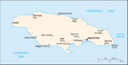
Jamaica is an island nation of the Greater Antilles, in length, up to in width and 10,990 square kilometres in area. It is situated in the Caribbean Sea, about south of Cuba, and west of Hispaniola, the island harbouring the nation-states Haiti and the Dominican Republic...
. The following definitions have been used:
- City: Any settlement listed at that had a 1991 or 2001 census population of 75,000 or more. These are believed to be cities by Charter or by Act of the Jamaican parliament but no source for this has been found.
- Town: As given at plus any other settlements with a 1991 census population of between 750 and 75,000.
- Village Any settlement not listed at and with a 1991 census population of less than 750.
- Hamlet: Any settlement not listed at and which Google Maps satellite view shows is too small to be a village.
- Neighbourhood: Geographically obvious subdivisions of any of the above.
Cities and towns
| Name | Pop. Population A population is all the organisms that both belong to the same group or species and live in the same geographical area. The area that is used to define a sexual population is such that inter-breeding is possible between any pair within the area and more probable than cross-breeding with individuals... (1991) | Coordinates Geographic coordinate system A geographic coordinate system is a coordinate system that enables every location on the Earth to be specified by a set of numbers. The coordinates are often chosen such that one of the numbers represent vertical position, and two or three of the numbers represent horizontal position... | Parish Parishes of Jamaica Administratively, Jamaica is divided into fourteen parishes. They are grouped into three historic counties, which have no administrative relevance :... |
|---|---|---|---|
| Cities | |||
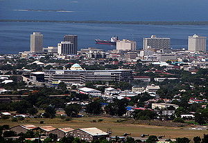
| Kingston Kingston, Jamaica Kingston is the capital and largest city of Jamaica, located on the southeastern coast of the island. It faces a natural harbour protected by the Palisadoes, a long sand spit which connects the town of Port Royal and the Norman Manley International Airport to the rest of the island... |
587,798 | 17.9833°N 76.8000°W | Kingston / St. Andrew Saint Andrew Parish, Jamaica Saint Andrew is a parish, situated in the southeast of Jamaica in the county of Surrey. It lies north, west and east of Kingston, and stretches into the Blue Mountains and at the 2001 census had the highest population of all the parishes in Jamaica. The Right Excellent George William Gordon Saint... |
| Montego Bay Montego Bay Montego Bay is the capital of St. James Parish and the second largest city in Jamaica by area and the fourth by population .It is a tourist destination with duty free shopping, cruise line terminal and the beaches... |
96,488 | 18.4666°N 77.9166°W | Saint James Saint James Parish, Jamaica St James is a suburban parish, located on the north west end of the island of Jamaica. Its capital, Montego Bay, derived from the Spanish word Manteca because many wild hogs were found there from which they made lard. It was named publicly the second city of Jamaica, behind Kingston, in 1981.... |
| Towns | |||
| Above Rocks Above Rocks Above Rocks is a town in the parish of Saint Catherine in Jamaica.Above Rocks was populated in the early 19th century by refugees from the Haitian revolution.... |
3,263 | 18.1089°N 76.8772°W | Saint Catherine |
| Albert Town Albert Town, Jamaica Albert Town is a town in the parish of Trelawny in Jamaica.- External links :*... |
3,389 | 18.2958°N 77.5414°W | Trelawny |
| Alexandria Alexandria, Jamaica Alexandria is a town in the parish of Saint Ann in Jamaica.The Armadale Juvenile Correctional Centre of the Department of Correctional Services, Jamaica was located in Alexandria. On 22 May 2009 a fire went through the facility, killing 5 girls and injuring 13 girls... |
1,672 | 18.2983°N 77.3575°W | Saint Ann |
| Alligator Pond Alligator Pond Alligator Pond is a fishing village on the southwestern coast of Jamaica in the parish of Saint Elizabeth.Unlike the tourist-oriented coasts in the northern part of the country, Alligator Pond's shoreline is as much about work as play; here fishermen launch their boats to catch some of the island's... |
1,542 | 17.8711°N 77.5683°W | Manchester |
| Anchovy Anchovy, Jamaica Anchovy is a small town in the parish of Saint James in northwestern Jamaica. It is located south-southwest of Montego Bay.-Road:Anchovy is on the B8 road which runs from Savanna-la-Mar on the south coast to Reading on the north coast.- Rail :... |
3,633 | 18.4097°N 77.9339°W | Saint James Saint James Parish, Jamaica St James is a suburban parish, located on the north west end of the island of Jamaica. Its capital, Montego Bay, derived from the Spanish word Manteca because many wild hogs were found there from which they made lard. It was named publicly the second city of Jamaica, behind Kingston, in 1981.... |
| Annotto Bay Annotto Bay Annotto Bay is a town in the parish of Saint Mary in Jamaica. - External links :*... |
5,468 | 18.2703°N 76.7706°W | Saint Mary Saint Mary Parish, Jamaica Saint Mary is a parish located in the northeast section of Jamaica. With a population of 115,000 it is one of Jamaica's smallest parishes, located in the county of Middlesex. Its chief town and capital is Port Maria, located on the coast. It is also the birthplace of established dancehall reggae... |
| Balaclava Balaclava, Jamaica Balaclava is a small town in St Elizabeth, Jamaica.Balacalva has a lively pretty Market, and the St Luke Anglican Church , where many victims of the Kendall Train Crash are buried.... |
2,837 | 18.1705°N 77.6484°W | Saint Elizabeth |
| Bamboo Bamboo, Jamaica Bamboo is a settlement in Saint Ann Parish in Jamaica. Its population as of a 1991 census was 3,732 inhabitants.The Hill Top Juvenile Correctional Centre of the Department of Correctional Services, Jamaica is located in Bamboo.... |
3,732 | 18.3851°N 77.2662°W | Saint Ann |
| Bath Bath, Jamaica Bath is a settlement in Jamaica.... |
2,151 | 17.95°N 76.35°W | Saint Thomas Saint Thomas Parish, Jamaica Saint Thomas is a suburban parish that is situated at the south eastern end of Jamaica, in the county of Surrey. It is the birth place of The right Honorable Paul Bogle, one of Jamaica's seven National Heroes... |
| Bethel Town | 2,768 | 18.30°N 77.95°W | Westmoreland |
| Black River Black River, Jamaica Black River is the capital of St. Elizabeth Parish, in southwestern Jamaica. It sits at the mouth of the river of the same name. Once a thriving sugar port, it is today a centre of environmental tourism and a gateway to the Treasure Beach resort area; Treasure Beach and Crane Beach are to the... |
3,675 | 18.03°N 77.86°W | Saint Elizabeth |
| Bluefields Bluefields, Jamaica Bluefields is a settlement in the West Indian island of Jamaica.... |
2,564 | 18.17°N 78.03°W | Westmoreland |
| Bog Walk Bog Walk Bog Walk is a town in the parish of Saint Catherine, Jamaica... |
8,794 | 18.10°N 77.02°W | Saint Catherine |
| Brown's Town Brown's Town Brown's Town is one of the principal towns in St. Ann, Jamaica. In 1991, its population was 6762. The town is a market and road center in an agricultural region.-Geography:... |
6,762 | 18.40°N 77.36°W | Saint Ann |
| Buff Bay | 2,596 | 18.23°N 76.67°W | Portland |
| Bull Savanna | 17.88°N 77.59°W | Saint Elizabeth | |
| Cambridge Cambridge, Jamaica Cambridge is a settlement in Jamaica.... |
3,384 | 18.32°N 77.89°W | Saint James Saint James Parish, Jamaica St James is a suburban parish, located on the north west end of the island of Jamaica. Its capital, Montego Bay, derived from the Spanish word Manteca because many wild hogs were found there from which they made lard. It was named publicly the second city of Jamaica, behind Kingston, in 1981.... |
| Cascade Cascade, Jamaica Cascade is a settlement in Jamaica.... |
1,220 | 18.40°N 78.10°W | Hanover |
| Cave Valley Cave Valley, Jamaica Cave Valley is a settlement in Jamaica.... |
1,777 | 18.27°N 77.37°W | Saint Ann |
| Chapelton Chapelton, Jamaica Chapelton is a market town in Clarendon Parish, Jamaica and the former parish capital.-Name:According to a long time resident:-Amenities:*Clarendon College, secondary school.*Clarendon Hospital, built c1903, now a community Type 3 hospital.*.... |
3,930 | 18.08°N 77.27°W | Clarendon |
| Sanguinetti | 3,900 | 18.10°N 77.34°W | Clarendon |
| Christiana Christiana, Jamaica Christiana is a settlement in Jamaica.... |
7,235 | 18.17°N 77.49°W | Manchester |
| Claremont Claremont, Jamaica Claremont is a settlement in Jamaica.... |
2,154 | 18.38°N 77.17°W | Saint Ann |
| Clark's Town | 3,139 | 18.42°N 77.57°W | Trelawny |
| Coleyville | 3,320 | 18.22°N 77.50°W | Manchester |
| Constant Spring | 12,369 | 18.05°N 76.78°W | Saint Andrew Saint Andrew Parish, Jamaica Saint Andrew is a parish, situated in the southeast of Jamaica in the county of Surrey. It lies north, west and east of Kingston, and stretches into the Blue Mountains and at the 2001 census had the highest population of all the parishes in Jamaica. The Right Excellent George William Gordon Saint... |
| Croft's Hill | 2,994 | 18.13°N 77.22°W | Clarendon |
| Dalvey | 2,742 | 17.90°N 76.25°W | Saint Thomas Saint Thomas Parish, Jamaica Saint Thomas is a suburban parish that is situated at the south eastern end of Jamaica, in the county of Surrey. It is the birth place of The right Honorable Paul Bogle, one of Jamaica's seven National Heroes... |
| Darliston Darliston Darliston is a settlement in Jamaica.Darliston is a town in Westmoreland Parish in western Jamaica. It is located east-northeast of Savanna-la-Mar. In 1991 the population was 1,435... |
1,435 | 18.23°N 77.97°W | Westmoreland |
| Discovery Bay Discovery Bay, Jamaica Discovery Bay is a town in Saint Ann Parish on the northern coast of Jamaica. The city is also known locally as Dry Harbour Bay, because it sits in the shadow of the Dry Harbour Mountains in St. Ann. There is a dispute as to whether Christopher Columbus first landed in Discovery Bay or Sevilla la... (Dry Harbour) |
2,230 | 18.47°N 77.39°W | Saint Ann |
| Duncans | 1,849 | 18.47°N 77.53°W | Trelawny |
| Easington Easington, Jamaica Easington is a settlement in Jamaica.... |
2,378 | 17.92°N 76.60°W | Saint Thomas Saint Thomas Parish, Jamaica Saint Thomas is a suburban parish that is situated at the south eastern end of Jamaica, in the county of Surrey. It is the birth place of The right Honorable Paul Bogle, one of Jamaica's seven National Heroes... |
| Ewarton Ewarton -History:The name is most likely a compound of the surname "Ewart" and the suffix -ton, meaning town.The town's economy prospered particularly from 1957 when ALCAN established a bauxite plant nearby... |
8,742 | 18.18°N 77.08°W | Saint Catherine |
| Falmouth Falmouth, Jamaica Falmouth is the chief town and capital of the parish of Trelawny in Jamaica. It is situated on Jamaica's north coast 18 miles east of Montego Bay. It is noted for being one of the Caribbean’s best-preserved Georgian towns.... |
7,245 | 18.49°N 77.66°W | Trelawny |
| Frankfield Frankfield Frankfield is a town in Clarendon in central Jamaica. It is located near the top of Jamaica's central ridge of mountains overlooking the south coast... |
2,865 | 18.15°N 77.35°W | Clarendon |
| Frome Frome, Jamaica Frome is a settlement in Jamaica.... |
900 | 18.30°N 78.15°W | Westmoreland |
| Gayle Gayle, Jamaica Gayle is a settlement in Jamaica. It has a population of 3,238 as of 2009.... |
3,205 | 18.33°N 77.00°W | Saint Mary Saint Mary Parish, Jamaica Saint Mary is a parish located in the northeast section of Jamaica. With a population of 115,000 it is one of Jamaica's smallest parishes, located in the county of Middlesex. Its chief town and capital is Port Maria, located on the coast. It is also the birthplace of established dancehall reggae... |
| German Town | 4,108 | 18.15°N 77.54°W | Westmoreland |
| Golden Grove Golden Grove, Jamaica Golden Grove is a settlement in the parish of St. Thomas, Jamaica. It has a population of 3,057 as of 2009.... |
2,761 | 17.93°N 76.27°W | Saint Thomas Saint Thomas Parish, Jamaica Saint Thomas is a suburban parish that is situated at the south eastern end of Jamaica, in the county of Surrey. It is the birth place of The right Honorable Paul Bogle, one of Jamaica's seven National Heroes... |
| Gordon Town | 1,049 | 18.05°N 76.70°W | Saint Andrew Saint Andrew Parish, Jamaica Saint Andrew is a parish, situated in the southeast of Jamaica in the county of Surrey. It lies north, west and east of Kingston, and stretches into the Blue Mountains and at the 2001 census had the highest population of all the parishes in Jamaica. The Right Excellent George William Gordon Saint... |
| Grange Hill Grange Hill, Jamaica Grange Hill is a settlement in Jamaica. It has a population of 7,190 as of 2009.... |
6,530 | 18.37°N 78.20°W | Westmoreland |
| Green Island Green Island, Jamaica Green Island is a small town in northwestern Jamaica, located on the west coast between Negril and Lucea in the parish of Hanover. It is located close to Orange Bay.It is a beautiful place with one of the finest schools in Jamaica and a good harbour.... |
1,591 | 18.38°N 78.58°W | Hanover |
| Guy's Hill | 3,165 | 18.25°N 77.00°W | Saint Mary Saint Mary Parish, Jamaica Saint Mary is a parish located in the northeast section of Jamaica. With a population of 115,000 it is one of Jamaica's smallest parishes, located in the county of Middlesex. Its chief town and capital is Port Maria, located on the coast. It is also the birthplace of established dancehall reggae... |
| Hayes Hayes, Jamaica Hayes is a settlement in Jamaica. It has a population of 9,798 as of 2009.... |
8,447 | 17.88°N 77.25°W | Clarendon |
| Highgate Highgate, Jamaica Highgate is a settlement in Jamaica. It has a population of 5,474 as of 2009.... |
5,418 | 18.32°N 76.87°W | Saint Mary Saint Mary Parish, Jamaica Saint Mary is a parish located in the northeast section of Jamaica. With a population of 115,000 it is one of Jamaica's smallest parishes, located in the county of Middlesex. Its chief town and capital is Port Maria, located on the coast. It is also the birthplace of established dancehall reggae... |
| Hope Bay Hope Bay, Jamaica Hope Bay is a settlement in Jamaica. It had a population of 1,646 as of 2009.... |
1,569 | 18.20°N 76.57°W | Portland |
| Hopewell Hopewell, Hanover Hopewell is a settlement in Hanover Parish, Jamaica.... |
4,268 | 18.25°N 78.30°W | Hanover |
| Islington Islington, Jamaica Islington is a settlement in Jamaica. It has a population of 2,897 as of 2009.... |
2,868 | 18.32°N 76.85°W | Saint Mary Saint Mary Parish, Jamaica Saint Mary is a parish located in the northeast section of Jamaica. With a population of 115,000 it is one of Jamaica's smallest parishes, located in the county of Middlesex. Its chief town and capital is Port Maria, located on the coast. It is also the birthplace of established dancehall reggae... |
| Kellits | 2,291 | 18.17°N 77.23°W | Clarendon |
| Lacovia Lacovia Lacovia is a town in Saint Elizabeth Parish, Jamaica, located on the Black River between the Upper Morass and the Lower Morrass.-History:The name derives from La Caoban, the name of the place during the Spanish occupation. Following the English invasion it was called Coby... |
3,159 | 18.07°N 77.75°W | Saint Elizabeth |
| Linstead Linstead Linstead is a town in the parish of St. Catherine, Jamaica in the West Indies. In 1991 its population was 14,144. It is located 12 mi/19 km NNW of Spanish Town.-Description:... |
14,114 | 18.15°N 77.02°W | Saint Catherine |
| Lionel Town | 4,669 | 17.80°N 77.23°W | Clarendon |
| Little London Little London, Jamaica Little London is a town in the Parish of Westmoreland Parish, Jamaica. Little London sits midway between the town of Negril to the north and the Parish Capital Savanna-la-Mar to the south.... |
1,848 | 18.30°N 78.20°W | Westmoreland |
| Lluidas Vale | 2,161 | 18.12°N 77.15°W | Saint Catherine |
| Lucea | 6,002 | 18.44°N 78.18°W | Hanover |
| Lucky Hill Lucky Hill Lucky Hill is a town in the Gayle District of Saint Mary Parish, Jamaica.... |
750 | 18.30°N 77.02°W | Saint Mary Saint Mary Parish, Jamaica Saint Mary is a parish located in the northeast section of Jamaica. With a population of 115,000 it is one of Jamaica's smallest parishes, located in the county of Middlesex. Its chief town and capital is Port Maria, located on the coast. It is also the birthplace of established dancehall reggae... |
| Maggotty Maggotty Maggotty is a settlement in Jamaica. It has a population of 1,335 as of 2009.Was a Bauxite mining town in the 1960s and 1970s.The Revere Bauxite plant poluted the lingest river on the Island of Jamaica; the Black River.... |
1,359 | 18.15°N 77.77°W | Saint Elizabeth |
| Malvern Malvern, Jamaica Malvern is a village in the Santa Cruz Mountains in Jamaica's St. Elizabeth parish.It is the site of Bethlehem Moravian College, Munro College and Hampton School which is just as old.... |
3,262 | 17.97°N 77.72°W | Saint Elizabeth |
| Manchioneal | 2,185 | 18.05°N 76.28°W | Portland |
| Mandeville Mandeville, Jamaica Mandeville is the capital and largest town in the parish of Manchester in the county of Middlesex, Jamaica. In 2005, the town had an estimated population of 50,000, and including the immediate suburbs within a radius of the total population is about 72,000. It is located on an inland plateau at an... |
39,945 | 18.05°N 77.48°W | Manchester |
| Maroon Town | 2,669 | 18.35°N 77.79°W | Saint James Saint James Parish, Jamaica St James is a suburban parish, located on the north west end of the island of Jamaica. Its capital, Montego Bay, derived from the Spanish word Manteca because many wild hogs were found there from which they made lard. It was named publicly the second city of Jamaica, behind Kingston, in 1981.... |
| Mavis Bank | 1,756 | 18.02°N 76.67°W | Saint Andrew Saint Andrew Parish, Jamaica Saint Andrew is a parish, situated in the southeast of Jamaica in the county of Surrey. It lies north, west and east of Kingston, and stretches into the Blue Mountains and at the 2001 census had the highest population of all the parishes in Jamaica. The Right Excellent George William Gordon Saint... |
| May Pen May Pen May Pen is the capital and largest town in the parish of Clarendon in the Middlesex County, Jamaica. It is located on the Rio Minho river , and is a major market centre for the Parish... |
45,903 | 17.97°N 77.24°W | Clarendon |
| Moneague Moneague Moneague is a small town in Saint Ann, Jamaica on the main road between Kingston and Ocho Rios.In the colonial days, the town prospered as a stopover for the rich English on their journey.... |
2,880 | 18.28°N 77.10°W | Saint Ann |
| Moore Town | 1,054 | 18.07°N 76.43°W | Portland |
| Morant Bay Morant Bay Morant Bay is a town in southeastern Jamaica. It is the capital of the parish of St. Thomas. In 1867 it was the starting point of the Morant Bay Rebellion, the only major peasant revolt , in Jamaican history... |
9,602 | 17.87°N 76.39°W | Saint Thomas Saint Thomas Parish, Jamaica Saint Thomas is a suburban parish that is situated at the south eastern end of Jamaica, in the county of Surrey. It is the birth place of The right Honorable Paul Bogle, one of Jamaica's seven National Heroes... |
| Nain Nain, Jamaica Nain is a settlement in Jamaica. It has a population of 2,331 as of 2009.... |
2,373 | 17.97°N 77.60°W | Saint Elizabeth |
| Negril Negril Negril is a small but widely dispersed beach resort town located across parts of two Jamaican parishes of Westmoreland and Hanover. Westmoreland is the westernmost parish in Jamaica, located on the south side of the island... |
4,184 | 18.32°N 78.33°W | Westmoreland |
| Ocho Rios Ocho Rios Ocho Ríos is a town in the parish of Saint Ann on the north coast of Jamaica. Although he landed in many spots along the Jamaican coast, many believe that Christopher Columbus first set foot on land in Ocho Rios... |
8,189 | 18.42°N 77.11°W | Saint Ann |
| Old Harbour | 17,778 | 17.92°N 77.10°W | Saint Catherine |
| Old Harbour Bay | 5,405 | 17.90°N 77.10°W | Saint Catherine |
| Oracabessa Oracabessa Oracabessa is a small town in St Mary, Jamaica east of Ocho Rios. Its population was 4,108 in 2009.Lit in the afternoons by an apricot light that may have inspired its Spanish name Oracabeza, or "Golden Head", it is a friendly town with a covered produce market and a few shops and bars... |
4,066 | 18.47°N 76.93°W | Saint Mary Saint Mary Parish, Jamaica Saint Mary is a parish located in the northeast section of Jamaica. With a population of 115,000 it is one of Jamaica's smallest parishes, located in the county of Middlesex. Its chief town and capital is Port Maria, located on the coast. It is also the birthplace of established dancehall reggae... |
| Osbourne Store | 3,390 | 17.97°N 77.33°W | Clarendon |
| Petersfield Petersfield, Jamaica Petersfield is a small town in Westmoreland Parish, Jamaica. It shares its name with five other places in Jamaica.The town was founded in the 18th century and named after Peter Beckford, a slave owner who settled the Roaring River Estate... |
2,045 | 18.25°N 78.07°W | Westmoreland |
| Point Hill | 3,651 | 18.08°N 77.10°W | Saint Catherine |
| Port Antonio Port Antonio Port Antonio is the capital of the parish of Portland on the northeastern coast of Jamaica, about 60 miles from Kingston. It had a population of 12,285 in 1982 and 13,246 in 1991... |
13,246 | 18.16°N 76.38°W | Portland |
| Port Maria Port Maria Port Maria is the capital town of the Jamaican parish of Saint Mary. It has a population of approximately 7,500 people and is the seat of the Saint Mary Parish Council. The Mayor of Port Maria is Richard Creary... |
7,651 | 18.37°N 76.89°W | Saint Mary Saint Mary Parish, Jamaica Saint Mary is a parish located in the northeast section of Jamaica. With a population of 115,000 it is one of Jamaica's smallest parishes, located in the county of Middlesex. Its chief town and capital is Port Maria, located on the coast. It is also the birthplace of established dancehall reggae... |
| Port Royal Port Royal Port Royal was a city located at the end of the Palisadoes at the mouth of the Kingston Harbour, in southeastern Jamaica. Founded in 1518, it was the centre of shipping commerce in the Caribbean Sea during the latter half of the 17th century... |
3,004 | 17.93°N 76.85°W | Kingston |
| Portmore Portmore Portmore is a coastal city in southern Jamaica in Saint Catherine, and a dormitory town for the neighbouring cities of Kingston and Spanish Town.-Geography:... |
90,138 | 17.9499°N 76.8799°W | Saint Catherine |
| Porus Porus, Jamaica Porus is a village in Manchester, Jamaica. It overlooks a plain to the south with hills behind it to the north. A tributary of the Rio Minho runs parallel to the main road, helping to keep the atmosphere cool.-History:... |
5,095 | 18.03°N 77.42°W | Manchester |
| Race Course Race Course, Jamaica Race Course is a settlement in Clarendon Parish in Jamaica. It has a population of 3,003 as of 2009.... |
2,589 | 17.83°N 77.28°W | Clarendon |
| Richmond Richmond, Jamaica Richmond is a market town in Saint Mary parish, in the north-east of Jamaica.- See also :* Geography of Jamaica* List of cities and towns in Jamaica* Railway stations in Jamaica- References :... |
1,984 | 18.23°N 76.90°W | Saint Mary Saint Mary Parish, Jamaica Saint Mary is a parish located in the northeast section of Jamaica. With a population of 115,000 it is one of Jamaica's smallest parishes, located in the county of Middlesex. Its chief town and capital is Port Maria, located on the coast. It is also the birthplace of established dancehall reggae... |
| Rio Bueno Rio Bueno, Jamaica Rio Bueno is a settlement in Jamaica. It has a population of 1,096 as of 2009.... |
1,108 | 18.57°N 77.45°W | Trelawny |
| Riversdale Riversdale, Jamaica Riversdale is a settlement in Jamaica. It has a population of 4,408 as of 2009.... |
2,791 | 18.15°N 76.97°W | Saint Catherine |
| Rocky Point Rocky Point, Jamaica Rocky Point is a settlement in Jamaica. It has a population of 3,183 as of 2009.... |
2,744 | 17.77°N 77.27°W | Clarendon |
| Runaway Bay Runaway Bay, Jamaica Runaway Bay is a town in Saint Ann Parish on the northern coast of Jamaica. Runaway Bay is a notable tourist destination located 16 km west of Ocho Ríos, and slightly east of Discovery Bay. It is also the location of the Hedonism III nudist resort. Ocean View Beach is a private beach situated at... |
5,655 | 18.45°N 77.33°W | Saint Ann |
| Saint Ann's Bay | 10,961 | 18.44°N 77.22°W | Saint Ann |
| Sandy Bay Sandy Bay, Jamaica Sandy Bay, Jamaica is a seaside town in western Jamaica. There are several churches such as the Seventh-day Adventist Church, the Baptist Church, the Methodist Church, and the Church of God.... |
4,476 | 18.45°N 78.10°W | Hanover |
| Santa Cruz Santa Cruz, Jamaica Santa Cruz is a town in Saint Elizabeth, Jamaica, on the A2 road connecting Black River to Mandeville. A minor market village until the 1950s, the development of nearby areas for bauxite mining stimulated its growth in the 1950s and 1960s, as did the establishment of the St. Elizabeth Technical... |
8,144 | 18.07°N 77.72°W | Saint Elizabeth |
| Savanna-la-Mar Savanna-la-Mar Savanna-la-Mar is the chief town and capital of Westmoreland parish, Jamaica.It is a coastal town and contains a fort, constructed in the 18th century for defence against pirates.... |
16,553 | 18.16°N 77.95°W | Westmoreland |
| Seaforth Seaforth, Jamaica Seaforth is a settlement in Jamaica. It has a population of 4,548 as of 2009.... |
4,108 | 17.93°N 76.45°W | Saint Thomas Saint Thomas Parish, Jamaica Saint Thomas is a suburban parish that is situated at the south eastern end of Jamaica, in the county of Surrey. It is the birth place of The right Honorable Paul Bogle, one of Jamaica's seven National Heroes... |
| Siloah | 2,701 | 18.17°N 77.73°W | Saint Elizabeth |
| Southfield Southfield, Jamaica Southfield is a village and farming community on the southern ridge of the Santa Cruz Mountains in St Elizabeth, Jamaica. It is the site of the Mannings Boys Home.-History:... |
2,671 | 17.88°N 77.67°W | Saint Elizabeth |
| Spanish Town Spanish Town Spanish Town is the capital and the largest town in the parish of St. Catherine in the county of Middlesex, Jamaica. It was the former Spanish and English capital of Jamaica from the 16th to the 19th century... |
92,383 | 17.9958°N 76.9551°W | Saint Catherine |
| Stony Hill | 8,244 | 18.08°N 76.78°W | Saint Andrew Saint Andrew Parish, Jamaica Saint Andrew is a parish, situated in the southeast of Jamaica in the county of Surrey. It lies north, west and east of Kingston, and stretches into the Blue Mountains and at the 2001 census had the highest population of all the parishes in Jamaica. The Right Excellent George William Gordon Saint... |
| Trinity Ville | 2,614 | 17.95°N 76.53°W | Saint Thomas Saint Thomas Parish, Jamaica Saint Thomas is a suburban parish that is situated at the south eastern end of Jamaica, in the county of Surrey. It is the birth place of The right Honorable Paul Bogle, one of Jamaica's seven National Heroes... |
| Ulster Spring | 1,391 | 18.32°N 77.52°W | Trelawny |
| Wakefield Wakefield, Jamaica Wakefield is a settlement in Jamaica. It has a population of 2,694 as of 2009.... |
2,724 | 18.42°N 77.72°W | Trelawny |
| White House White House, Jamaica White House is a settlement in Jamaica. It has a population of 3,476 as of 2009.... |
3,157 | 18.08°N 77.97°W | Westmoreland |
| Williamsfield Williamsfield, Jamaica Williamsfield is a settlement in Jamaica. It has a population of 3,299 as of 2009.... |
2,800 | 18.07°N 77.48°W | Manchester |
| Yallahs Yallahs Yallahs is a town located on the southeastern coast of Jamaica in the parish of St Thomas and is home to an estimated 10,000 inhabitants. The Yallahs River is a source of fresh water for the inhabitants of the neighbouring City Of Kingston and St. Andrew and provides them with water through the... |
6,902 | 17.87°N 76.57°W | Saint Thomas Saint Thomas Parish, Jamaica Saint Thomas is a suburban parish that is situated at the south eastern end of Jamaica, in the county of Surrey. It is the birth place of The right Honorable Paul Bogle, one of Jamaica's seven National Heroes... |
Villages
- AccompongAccompongAccompong is a historical maroon village, located in the hills of St. Elizabeth Parish in Jamaica, consolidated by a treaty in 1739. It is located in one of the two areas where runaway slaves settled, originally with the Taínos, isolated enough to be safe first from the Spanish and then later from...
(Saint Elizabeth) - Aeolus ValleyAeolus ValleyAeolus Valley is a village in the Yallahs district of the Jamaican parish of Saint Thomas. Although there has been a recent wave of violence and murders, residents still say that "valley a nice place".-Prominent people from Aeolus Valley:...
(Saint Thomas) - Airy CastleAiry CastleAiry Castle is a village in the Jamaican parish of Saint Thomas....
(Saint Thomas) - Barking LodgeBarking LodgeBarking Lodge is a small village close to the south-east coast of the Caribbean island of Jamaica and located in the parish of St. Thomas within the county of Surrey....
(Saint Thomas) - BogBog, Westmoreland, JamaicaBog is a settlement in Jamaica. It has a population of 13,889 as of 2009....
(Westmoreland) - Big WoodsBig Woods, Westmoreland, JamaicaBig Woods is a settlement in Jamaica....
(Westmoreland) - BoscobelBoscobel, JamaicaBoscobel is located in St. Mary Parish on the north shore of Jamaica, ten miles east of Ocho Rios. It is home to Ian Fleming International Airport and is located approximately half-way between Montego Bay and Kingston.-References:...
(Saint Mary) - Bull BayBull BayBull Bay is located on the south east coast of Jamaica 10 miles to the East of Kingston in the parish of St Andrew.-Floods:Bull Bay is located in the flood plain of a number of rivers: Salt Spring River, Chalky River, Bull Park River, Spring Gut River and Cane River, and consequently has been the...
(Saint Andrew) - CarmelCarmel, Westmoreland, JamaicaCarmel is a settlement in Jamaica....
(Westmoreland) - Cattawood SpringsCattawood SpringsCattawood Springs is a place in Portland Parish, Jamaica located at latitude 18 04' 00", longitude 76 26' 00".Originally this was a Maroon settlement. This name probably derives from the Twi word katá which means to cover conceal or protect....
(Portland) - Clarendon ParkClarendon Park, JamaicaClarendon Park is a settlement in Clarendon Parish in south-central Jamaica.It is the birthplace of Sandie Richards, a track and field bronze medal winner at the 2004 Summer Olympics.- Transport :...
(Clarendon) - CotterwoodCotterwoodCotterwood is a town in Saint Elizabeth Parish, Jamaica. It is at latitude 18° 4' 60" N, Longitude 77° 54' 0" W and at an altitude of 107 metres....
(Saint Elizabeth) - DuckenfieldDuckenfield, JamaicaDuckenfield, Jamaica is a village in St Thomas, in south-east Jamaica. It is named after the sugar plantation on which it is located. It is a very poor community, but it has grown substantially in recent years...
(Saint Thomas) - Four Paths
- Franklin TownFranklin Town, JamaicaFranklin Town is a settlement in Jamaica....
- HaddersfieldHaddersfield, JamaicaHaddersfield, also known as Huddersfield, is a small town located in the St Mary parish of Jamaica. It is located at 18°24' N, 77°1' W, close to the small town of 'Retreat' and the mouth of the 'Rio Nuevo', some 10 kilometres east of Ocho Rios...
(Saint Mary) - Hagley GapHagley GapHagley Gap is a settlement in Saint Thomas parish in southeastern Jamaica. This small rural community is located from Kingston near the top of the Blue Mountains in Jamaica...
(Saint Thomas) - HodgesHodges, JamaicaHodges, Jamaica is located in Saint Elizabeth, Jamaica. It is a small hamlet on the main A2 road about north-west of Black River. Blink and you may miss it.-External links:* * Photos:*...
(Saint Elizabeth) - Hopewell HallHopewell HallHopewell Hall is a settlement in Saint Thomas Parish, Jamaica....
(Saint Thomas) - HopewellHopewell, ClarendonHopewell is a settlement in Clarendon Parish, Jamaica....
(Clarendon) - HopewellHopewell, ManchesterHopewell is a settlement in Manchester Parish, Jamaica....
(Manchester) - HopewellHopewell, Saint AndrewHopewell is a settlement in Saint Andrew Parish, Jamaica....
(Saint Andrew) - HopewellHopewell, Saint AnnHopewell is a settlement in Saint Ann Parish, Jamaica....
(Saint Ann) - HopewellHopewell, Saint ElizabethHopewell is a settlement in Saint Elizabeth Parish, Jamaica....
(Saint Elizabeth) - HopewellHopewell, WestmorelandHopewell is a settlement in Westmoreland Parish, Jamaica....
(Westmoreland) - HopetonHopeton, Westmoreland, JamaicaHopeton is a settlement in Jamaica....
(Westmoreland) - Long WoodLong Wood, Saint Elizabeth, JamaicaLong Wood is a settlement in Jamaica....
(Saint Elizabeth) - Mavis Bank (Saint Andrew)
- Middle QuartersMiddle Quarters, JamaicaMiddle Quarters is a settlement in Saint Elizabeth Parish in Jamaica.- External links :*...
(Saint Elizabeth) - Mount Rosser
- Nanny TownNanny TownNanny Town was a village in the Blue Mountains of Portland Parish, north-eastern Jamaica, used as a stronghold for Maroons led by Granny Nanny; the town held out against repeated British attacks before being destroyed in 1734....
(Portland) - New HollandNew Holland, Saint Elizabeth, JamaicaNew Holland is a settlement in Jamaica....
(Saint Elizabeth) - New MarketNew Market, JamaicaNew Market is a settlement in Saint Elizabeth Parish in Jamaica....
(Saint Elizabeth) - New RoadsNew Roads, Saint Elizabeth, JamaicaNew Roads is a settlement in Jamaica....
(Saint Elizabeth) - NewcastleNewcastle, JamaicaNewcastle is a settlement in the Blue Mountains of Jamaica. Formerly a military hill station for the British Army it is now a training centre for the Jamaica Defence Force....
- Nine Mile (Saint Ann)
- Old PeraOld Pera, JamaicaOld Pera is a small fishing village in south-eastern Jamaica, 15 minutes east of Morant Bay.The village is historic, with mountain and caribbean sea views.The area is known for its Cumina, a ritual celebration based on reverence for ancestors; it was brought to the island centuries ago by West...
- Paynes TownPaynes Town, Saint Elizabeth, JamaicaPaynes Town is a settlement in Jamaica....
(Saint Elizabeth) - Port Esquivel
- Port MorantPort MorantPort Morant is a town in southeastern Jamaica. It was, in the early years of European settlement, one of the island's chief ports, with export of bananas and production of rum being major industries....
(Saint Thomas) - RoxboroughRoxborough, ManchesterRoxborough is a small neighborhood and town south of Mandeville in Manchester Parish, Jamaica.The principle crops are corn, bananas, sugarcane, ackee and marijuana....
(Manchester) - San SanSan San, Portland, JamaicaSan San is a town in the parish of Portland in Jamaica.- Geography :San San is that bit of beautiful coast and mountain about 5 kilometers east of Port Antonio, Jamaica. San San encompasses about 2000 acres, from Drapers east to Blue Lagoon...
(Portland) - Sheckles Pen
- StonehengeStonehenge, Jamaica- Education :Orange Hill All Age School is just west of the crossroad. As of 2010 the school has three teachers and about 70 students.- References :...
- Vineyard Town
- Walderston
- White HallWhite Hall, Saint Elizabeth, JamaicaWhite Hall is a settlement in Jamaica....
(Saint Elizabeth) - Wood HallWood HallWood Hall is a town in St. Catherine Parish, Jamaica. Past Prime Minister of Jamaica Portia Simpson-Miller was born in Wood Hall in 1945....
(Saint Catherine)
Kingston
- Denham TownDenham TownDenham Town is a predominantly residential neighbourhood in west-central Kingston, Jamaica. It has a reputation as one of Kingston's more violent areas.-External links:*.*Photos:...
- Half Way TreeHalf Way TreeHalf Way Tree is a neighbourhood in the city of Kingston, Jamaica. It is the parish capital of St. Andrew.Half Way Tree is served by the Kingston 10 post office....
- Harbour ViewHarbour View, JamaicaHarbour View is a community in Saint Andrew Parish, Jamaica. It is administered by the Kingston and St. Andrew Corporation and is served by the Kingston 17 Post Office.-Geography:Harbour View is southeast of Long Mountain and south of Dallas Mountain...
- LiguaneaLiguaneaLiguanea is a historically significant area in the island of Jamaica in the West Indies. Its name came from the language of the pre-Columbian Taino people who inhabited the island and named it after the iguana lizard that is endemic to the island, and an important source of food for the...
- MonaMona, JamaicaMona is a neighbourhood in southeastern Saint Andrew Parish, approximately five miles from Kingston, Jamaica. A former sugar plantation, it is the site of a reservoir serving the city of Kingston and of the main campus of the University of the West Indies...
- New Kingston
- NorbrookNorbrookNorbrook is an upscale neighbourhood of the Kingston Metropolitan Area of Jamaica, with approximately 15,000 residents and is an important residential, shopping and commercial centre of the city itself. Norbrook is regarded as anywhere from the Immaculate Conception Highschool to about 100m up...
- TrenchtownTrenchtownTrench Town is a neighborhood located in the parish of St. Andrew which shares municipality with Kingston, the capital and largest city of Jamaica. In the 1960s Trench Town was known as the Hollywood of Jamaica. Today Trench Town boasts the Trench Town Culture Yard Museum, a visitor friendly...
External links
- World Gazetteer, Jamaica: Largest cities and towns with statistics of their population
- World Gazetteer, Jamaica: Maps