

List of airports in the Inland Empire Metropolitan Area
Encyclopedia
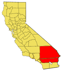
Inland Empire (California)
The Inland Empire is a region in Southern California. The region sits directly east of the Los Angeles metropolitan area. The Inland Empire most commonly is used in reference to the U.S. Census Bureau's federally-defined Riverside-San Bernardino-Ontario metropolitan area, which covers more than...
.
Commercial airports
- LA/Ontario International Airport , owned by Los Angeles World AirportsLos Angeles World AirportsLos Angeles World Airports or LAWA is the airport oversight and operations department for the city of Los Angeles, California, United States...
, located in the western portion of San Bernardino County, in the city of Ontario, CaliforniaOntario, CaliforniaOntario is a city located in San Bernardino County, California, United States, 35 miles east of downtown Los Angeles. Located in the western part of the Inland Empire region, it lies just east of the Los Angeles county line and is part of the Greater Los Angeles Area... - Palm Springs International AirportPalm Springs International AirportPalm Springs International Airport is a public airport located two miles east of the central business district of Palm Springs, California, serving the Inland Empire Metropolitan Area of Southern California. The airport covers and utilizes two runways...
, located in Palm Springs, CaliforniaPalm Springs, CaliforniaPalm Springs is a desert city in Riverside County, California, within the Coachella Valley. It is located approximately 37 miles east of San Bernardino, 111 miles east of Los Angeles and 136 miles northeast of San Diego...
, serving the Coachella ValleyCoachella ValleyCoachella Valley is a large valley landform in Southern California. The valley extends for approximately 45 miles in Riverside County southeast from the San Bernardino Mountains to the saltwater Salton Sea, the largest lake in California...
area of Riverside CountyRiverside County, CaliforniaRiverside County is a county in the U.S. state of California. One of 58 California counties, it covers in the southern part of the state, and stretches from Orange County to the Colorado River, which forms the state border with Arizona. The county derives its name from the city of Riverside,... - San Bernardino International AirportSan Bernardino International AirportSan Bernardino International Airport is a public airport located two miles southeast of the central business district of San Bernardino, California, in San Bernardino County, California, USA. The airport covers and has one runway. It is currently a general aviation and cargo airport located on...
, located in San Bernardino, CaliforniaSan Bernardino, CaliforniaSan Bernardino is a city located in the Riverside-San Bernardino metropolitan area , and serves as the county seat of San Bernardino County, California, United States...
and will serve as a major alternate airport in the Greater San Bernardino area.
Towered general aviation airports
- Chino AirportChino AirportChino Airport is a county-owned public-use airport located about three miles southeast of Chino, a town in San Bernardino County, California...
in Chino, CaliforniaChino, CaliforniaChino is a city in San Bernardino County, California, United States. It is located in the western end of the Riverside-San Bernardino Area and it is easily accessible via the Chino Valley and Pomona freeways.... - Riverside Municipal AirportRiverside Municipal AirportRiverside Municipal Airport , also known as Riverside Airport , is a public airport located four miles southwest of the central business district of Riverside, the county seat of Riverside County, California, United States...
in Riverside, CaliforniaRiverside, CaliforniaRiverside is a city in Riverside County, California, United States, and the county seat of the eponymous county. Named for its location beside the Santa Ana River, it is the largest city in the Riverside-San Bernardino-Ontario metropolitan area of Southern California, 4th largest inland California... - Southern California Logistics AirportSouthern California Logistics AirportSouthern California Logistics Airport , also known as Victorville Airport, is a public airport located in the city of Victorville in San Bernardino County, California approximately north of San Bernardino...
in VictorvilleVictorville, CaliforniaVictorville is a city located in the Victor Valley of southwestern San Bernardino County, California. According to the U.S. Census Bureau's 2010 census, the city had a population of 115,903, up from 64,030 at the 2000 census.-Geography and climate:...
in San Bernardino CountySan Bernardino County, CaliforniaSan Bernardino County is a county in the U.S. state of California. As of the 2010 census, the population was 2,035,210, up from 1,709,434 as of the 2000 census...
Non-towered general aviation airports
- Apple Valley AirportApple Valley Airport (California)Apple Valley Airport is a public airport located three miles north of Apple Valley, serving San Bernardino County, California, USA. The airport has two runways and is mostly used for general aviation.- Facilities :...
in Apple Valley, CaliforniaApple Valley, California-Climate:*On average, the warmest month is July.*The highest recorded temperature was in 2002.*On average, the coolest month is December.*The lowest recorded temperature was in 1949.*The most precipitation on average occurs in February.-History:... - Barstow-Daggett AirportBarstow-Daggett AirportBarstow-Daggett Airport is a county-owned public-use airport in San Bernardino County, California, United States. It is located four nautical miles east of the central business district of the town of Daggett, and east of the city of Barstow...
in Barstow, CaliforniaBarstow, CaliforniaBarstow is a city in San Bernardino County, California, United States. The population was 22,639 at the 2010 census, up from 21,119 at the 2000 census. Barstow is located north of San Bernardino.... - Big Bear City AirportBig Bear City AirportBig Bear City Airport is a public airport located in Big Bear City, San Bernardino County, California, United States.- Arrival and Departure :...
in Big Bear City, CaliforniaBig Bear City, CaliforniaBig Bear City is an unincorporated, census-designated place in San Bernardino County, California immediately east of Big Bear Lake. The population was 12,304 at the 2010 census, up from 5,779 at the 2000 census... - Cable AirportCable AirportCable Airport is a non-towered public-use airport located two miles northwest of the central business district of Upland, a city in San Bernardino County, California, United States. It is privately-owned by the Cable Land Company.-History:...
in Upland, CaliforniaUpland, CaliforniaUpland is a city in San Bernardino County, California, located at an elevation of 1,242 feet . As of the 2010 census, the city had a population of 73,732, up from 68,393 at the 2000 census. It was incorporated on May 15, 1906, after previously being named North Ontario.-History and culture:Upland... - Corona Municipal AirportCorona Municipal AirportCorona Municipal Airport , formerly L66, is a public airport located three miles northwest of Corona, serving Riverside County, California, United States.Although most U.S...
in Corona, CaliforniaCorona, CaliforniaCorona is a city in Riverside County, California, United States. As of the 2010 census, the city had a population of 152,374, up from 124,966 at the 2000 census... - Flabob AirportFlabob AirportFlabob Airport is a small public use airport located three nautical miles northwest of the central business district of Riverside, in Riverside County, California, United States. The airport is located in the city of Jurupa Valley beside the Santa Ana River...
in Jurupa Valley, CaliforniaJurupa Valley, CaliforniaJurupa Valley is a city of Riverside County, California. On March 8, 2011, voters approved a ballot measure to incorporate the area into its own city; as a result, the area has been an incorporated city since July 1, 2011.... - French Valley AirportFrench Valley AirportFrench Valley Airport is a county-owned public-use airport in southwestern Riverside County, California, located on Highway 79 near the communities of Murrieta and Temecula.- Facilities and aircraft :...
in Perris, CaliforniaPerris, CaliforniaPerris is a city in Riverside County, California, USA. At the 2010 census, the city population was 68,386, up from 36,189 at the 2000 census. The city is named in honor of Fred T. Perris, chief engineer of the California Southern Railroad... - Hemet-Ryan AirportHemet-Ryan AirportHemet-Ryan Airport is a county-owned, public-use airport located three nautical miles southwest of the central business district of Hemet, in Riverside County, California, United States....
in Hemet, CaliforniaHemet, CaliforniaHemet is a city in the San Jacinto Valley in Riverside County, California, United States. It covers a total area of , about half of the valley, which it shares with the neighboring city of San Jacinto. The population was 78,657 at the 2010 census.... - Needles AirportNeedles AirportNeedles Airport is a county-owned, public-use airport in San Bernardino County, California, United States. It is located five nautical miles south of the central business district of Needles. According to the FAA's National Plan of Integrated Airport Systems for 2009–2013, it is categorized as a...
in Needles, CaliforniaNeedles, CaliforniaNeedles is a city located in the Mojave Desert on the western banks of the Colorado River in San Bernardino County, California. It is located in the Mohave Valley, which straddles the California–Arizona border. The city is accessible via Interstate 40 and U.S. Route 95... - Redlands Municipal AirportRedlands Municipal AirportRedlands Municipal Airport is a public airport located two miles northeast of Downtown Redlands, serving San Bernardino County, California, USA. This general aviation airport covers and has one runway....
in Redlands, CaliforniaRedlands, CaliforniaRedlands is a city in San Bernardino County, California, United States. As of the 2010 census, the city had a population of 68,747, up from 63,591 at the 2000 census. The city is located east of downtown San Bernardino.- History :... - Rialto Municipal AirportRialto Municipal AirportRialto Municipal Airport , originally called Miro Field, is a general aviation airport located three miles northwest of the central business district of the city of Rialto, in San Bernardino County, California, USA....
in Rialto, CaliforniaRialto, California-2010:The 2010 United States Census reported that Rialto had a population of 99,171. The population density was 4,434.1 people per square mile . The racial makeup of Rialto was 43,592 White, 16,236 African American, 1,062 Native American, 2,258 Asian, 361 Pacific Islander, 30,993 from other...
Military aviation
- March Joint Air Reserve BaseMarch Joint Air Reserve BaseMarch Joint Air Reserve Base is located in Riverside County, California between the cities of Riverside and Moreno Valley. It is the home to the Air Force Reserve Command's 4th Air Force Headquarters and the 452d Air Mobility Wing , the largest air mobility wing of the 4th Air Force...
in RiversideRiverside, CaliforniaRiverside is a city in Riverside County, California, United States, and the county seat of the eponymous county. Named for its location beside the Santa Ana River, it is the largest city in the Riverside-San Bernardino-Ontario metropolitan area of Southern California, 4th largest inland California... - Former Norton Air Force BaseNorton Air Force BaseNorton Air Force Base is a former front-line United States Air Force facility located east of downtown San Bernardino, California in San Bernardino County.-Overview:...
, now San Bernardino International Airport, in San BernardinoSan BernardinoSan Bernardino, California is a large city in the Inland Empire Metropolitan Area of Southern California.San Bernardino may also refer to:-Landforms:*San Bernardino , a torrent that flows through the Italian province of Verbano-Cusio-Ossola... - Marine Corps Air Ground Combat Center Twentynine PalmsMarine Corps Air Ground Combat Center Twentynine PalmsThe Marine Corps Air Ground Combat Center , also known as 29 Palms, is a United States Marine Corps base. It was a census-designated place officially known as Twentynine Palms Base located adjacent to the city of Twentynine Palms in southern San Bernardino County, California. As of the 2000...
in Twentynine PalmsTwentynine Palms, CaliforniaTwentynine Palms is a city in San Bernardino County, California, United States. It was previously called Twenty-Nine Palms...