

List of airports in Antigua and Barbuda
Encyclopedia
Airport
An airport is a location where aircraft such as fixed-wing aircraft, helicopters, and blimps take off and land. Aircraft may be stored or maintained at an airport...
s in Antigua and Barbuda
Antigua and Barbuda
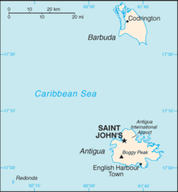
Antigua and Barbuda is a twin-island nation lying between the Caribbean Sea and the Atlantic Ocean. It consists of two major inhabited islands, Antigua and Barbuda, and a number of smaller islands...
, sorted by location.
Antigua and Barbuda is a nation lying between the Caribbean Sea
Caribbean Sea
The Caribbean Sea is a sea of the Atlantic Ocean located in the tropics of the Western hemisphere. It is bounded by Mexico and Central America to the west and southwest, to the north by the Greater Antilles, and to the east by the Lesser Antilles....
and the Atlantic Ocean
Atlantic Ocean
The Atlantic Ocean is the second-largest of the world's oceanic divisions. With a total area of about , it covers approximately 20% of the Earth's surface and about 26% of its water surface area...
. It consists of two major inhabited islands, Antigua
Antigua
Antigua , also known as Waladli, is an island in the West Indies, in the Leeward Islands in the Caribbean region, the main island of the country of Antigua and Barbuda. Antigua means "ancient" in Spanish and was named by Christopher Columbus after an icon in Seville Cathedral, Santa Maria de la...
and Barbuda
Barbuda
Barbuda is an island in the Eastern Caribbean, and forms part of the state of Antigua and Barbuda. It has a population of about 1,500, most of whom live in the town of Codrington.-Location:...
, and a number of smaller islands (including Great Bird, Green, Guinea, Long, Maiden and York Islands). Separated by a few nautical miles, the group is in the middle of the Leeward Islands
Leeward Islands
The Leeward Islands are a group of islands in the West Indies. They are the northern islands of the Lesser Antilles chain. As a group they start east of Puerto Rico and reach southward to Dominica. They are situated where the northeastern Caribbean Sea meets the western Atlantic Ocean...
, part of the Lesser Antilles
Lesser Antilles
The Lesser Antilles are a long, partly volcanic island arc in the Western Hemisphere. Most of its islands form the eastern boundary of the Caribbean Sea with the Atlantic Ocean, with the remainder located in the southern Caribbean just north of South America...
.
Airports
Names shown in bold indicate the airport has scheduled passenger service on commercial airlines.| City served | Island | ICAO ICAO airport code The ICAO airport code or location indicator is a four-character alphanumeric code designating each airport around the world. These codes are defined by the International Civil Aviation Organization, and published in ICAO Document 7910: Location Indicators.The ICAO codes are used by air traffic... |
IATA IATA airport code An IATA airport code, also known an IATA location identifier, IATA station code or simply a location identifier, is a three-letter code designating many airports around the world, defined by the International Air Transport Association... |
Airport name | Coordinates Geographic coordinate system A geographic coordinate system is a coordinate system that enables every location on the Earth to be specified by a set of numbers. The coordinates are often chosen such that one of the numbers represent vertical position, and two or three of the numbers represent horizontal position... |
|---|---|---|---|---|---|
| St. John's St. John's, Antigua and Barbuda St John's is the capital and largest city of Antigua and Barbuda, a country located in the West Indies in the Caribbean Sea. St John's is located at... |
Antigua Antigua Antigua , also known as Waladli, is an island in the West Indies, in the Leeward Islands in the Caribbean region, the main island of the country of Antigua and Barbuda. Antigua means "ancient" in Spanish and was named by Christopher Columbus after an icon in Seville Cathedral, Santa Maria de la... |
TAPA | ANU | V. C. Bird International Airport | 17°08′12"N 61°47′34"W |
| Codrington | Barbuda Barbuda Barbuda is an island in the Eastern Caribbean, and forms part of the state of Antigua and Barbuda. It has a population of about 1,500, most of whom live in the town of Codrington.-Location:... |
TAPH | BBQ | Codrington Airport | 17°38′09"N 61°49′43"W |
| Coco Point | Barbuda Barbuda Barbuda is an island in the Eastern Caribbean, and forms part of the state of Antigua and Barbuda. It has a population of about 1,500, most of whom live in the town of Codrington.-Location:... |
TAPT | Coco Point Lodge Airstrip (private) | 17°33′20"N 61°45′55"W |
See also
- Transport in Antigua and BarbudaTransport in Antigua and BarbudaAntigua and Barbuda's transport systems include both public and privately run services. Roads in the country are steep, winding, unpaved, and full of potholes. Driving is on the left-hand side. Volcanic ash which sometimes covers roads can make them slippery. The speed limit is set at 40 mph,...
- List of airports by ICAO code: T#TA - Antigua and Barbuda
- Wikipedia: WikiProject Aviation/Airline destination lists: North America#Antigua and Barbuda