

List of Pennsylvania state historical markers in Warren County
Encyclopedia
This is intended to be a complete list of the official state historical markers placed in Warren County, Pennsylvania
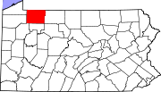
Warren County, Pennsylvania
Warren County is a county located in the U.S. state of Pennsylvania. As of 2010, the population was 41,815. It was formed in 1800 from parts of Allegheny and Lycoming counties; attached to Crawford County until 1805 and then to Venango County until Warren was formally organized in 1819. Its county...
by the Pennsylvania Historical and Museum Commission
Pennsylvania Historical and Museum Commission
The Pennsylvania Historical and Museum Commission is the governmental agency of the Commonwealth of Pennsylvania responsible for the collection, conservation and interpretation of Pennsylvania's historic heritage...
(PHMC). The locations of the historical markers, as well as the latitude and longitude coordinates as provided by the PHMC's database, are included below when available. There are 12 historical markers located in Warren County.
Historical markers
| Marker title | Image | Date dedicated | Location | Marker type | Topics |
|---|---|---|---|---|---|
| Buckaloons | Buckaloons Park, near U.S. 62 E of Irvine 41.83568°N 76.2574°W |
Roadside | Native American | ||
| Celoron's Expedition | Pennsylvania Ave. (Business U.S. 6) at Hickory St., Warren 41.84482°N 79.14923°W |
Roadside | Exploration, Government & Politics, Government & Politics 18th Century | ||
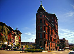
| Conewango Warren, Pennsylvania Warren is a city in Warren County, Pennsylvania, United States, located along the Allegheny River. The population was 9,710 at the 2010 census. It is the county seat of Warren County. It is home to the headquarters of the Allegheny National Forest and the Cornplanter State Forest... |
 |
Pennsylvania Ave. (Business U.S. 6), Conewango Creek Bridge, Warren 41.8437°N 79.14027°W |
Roadside | Early Settlement, Native American | |
| Gen. William Irvine | 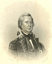 |
Old U.S. 6 (SR 3022) W of U.S. 62, Irvine 41.83987°N 79.26173°W |
Roadside | Professions & Vocations | |
| Grandin Well, The | US 62, .4 mile S of Allegheny River Bridge (Buckingham St.) near Tidioute 41.67693°N 79.41688°W |
Roadside | Business & Industry, Oil & Gas | ||
| Handsome Lake Handsome Lake Handsome Lake was a Seneca religious leader of the Iroquois people. He was also half-brother to Cornplanter.... |
Pa. 59 at Cornplanter (Missing) °N °W |
Roadside | Native American | ||
| Indian Paint Hill | U.S. 62, 3 miles NE of Tidioute 41.7084°N 79.34907°W |
Roadside | Native American | ||
| Robert Houghwout Jackson (1892-1954) Robert H. Jackson Robert Houghwout Jackson was United States Attorney General and an Associate Justice of the United States Supreme Court . He was also the chief United States prosecutor at the Nuremberg Trials... |
 |
Garland-Spring Creek (Rt. 426) & Eldred Hill Rds., Spring Creek 41.86705°N 79.51777°W |
Roadside | Government & Politics, Government & Politics 20th Century | |
| Seneca Crossing | Intersection of Warren-Onoville / Scandia Rds. (SR 1013) & Eqypt Hollow Rd., Glade Twp. °N °W |
Roadside | American Revolution, Exploration, Native American, Paths & Trails, Transportation | ||
| Sugar Run Mounds | Pa. 59 at Cornplanter (Missing) °N °W |
Roadside | Native American | ||
| Thompson's Island | US 62, ~4 miles S of Irvine 41.78407°N 79.21532°W |
Roadside | American Revolution, Military, Native American | ||
| Warren County Warren County, Pennsylvania Warren County is a county located in the U.S. state of Pennsylvania. As of 2010, the population was 41,815. It was formed in 1800 from parts of Allegheny and Lycoming counties; attached to Crawford County until 1805 and then to Venango County until Warren was formally organized in 1819. Its county... |
County Courthouse, 4th Ave. at Market St., Warren 41.848117°N 79.147°W |
City | Government & Politics, Government & Politics 19th Century |
See also
- List of Pennsylvania state historical markers
- National Register of Historic Places listings in Warren County, PennsylvaniaNational Register of Historic Places listings in Warren County, PennsylvaniaThis is a list of the National Register of Historic Places listings in Warren County, Pennsylvania.This is intended to be a complete list of the properties and districts on the National Register of Historic Places in Warren County, Pennsylvania, United States...