

List of Pennsylvania state historical markers in Union County
Encyclopedia
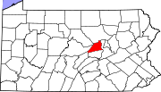
This is intended to be a complete list of the official state historical markers placed in Union County, Pennsylvania
Union County, Pennsylvania
-Demographics:As of the census of 2000, there were 41,624 people, 13,178 households, and 9,211 families residing in the county. The population density was 131 people per square mile . There were 14,684 housing units at an average density of 46 per square mile...
by the Pennsylvania Historical and Museum Commission
Pennsylvania Historical and Museum Commission
The Pennsylvania Historical and Museum Commission is the governmental agency of the Commonwealth of Pennsylvania responsible for the collection, conservation and interpretation of Pennsylvania's historic heritage...
(PHMC). The locations of the historical markers, as well as the latitude and longitude coordinates as provided by the PHMC's database, are included below when available. There are 22 historical markers located in Union County.
Historical markers
| Marker title | Image | Date dedicated | Location | Marker type | Topics |
|---|---|---|---|---|---|
| Bucknell University Bucknell University Bucknell University is a private liberal arts university located alongside the West Branch Susquehanna River in the rolling countryside of Central Pennsylvania in the town of Lewisburg, 30 miles southeast of Williamsport and 60 miles north of Harrisburg. The university consists of the College of... |
U.S. 15 in Lewisburg at stadium 40.95194°N 76.88729°W |
Roadside | Education, Religion, Women | ||
| Buffalo Church | Pa. 192, 4 miles W of Lewisburg 40.96218°N 76.96781°W |
Roadside | Buildings, Native American, Religion | ||
| Buffalo Church | Pa. 45, at Johnson Mill Rd., W of Lewisburg 40.9453°N 76.96647°W |
Roadside | Buildings, Native American, Religion | ||
| Col. John Kelly | SR 1002 just E of Mazeppa 40.98936°N 76.9818°W |
Roadside | American Revolution, Early Settlement, Military, Native American | ||
| Dry Run Cemetery | Pa. 304, 1 mile W of New Berlin (Missing) 40.8739°N 77.00804°W |
Roadside | Early Settlement, French & Indian War, Military, Religion | ||
| Eli Slifer | U.S. 15 just N of Lewisburg 40.97608°N 76.88773°W |
Roadside | Civil War, Government & Politics, Government & Politics 19th Century, Military | ||
| Evangelical Church Evangelical Association The Evangelical Church or Evangelical Association, also known as the Albright Brethren, is a "body of American Christians chiefly of German descent", Arminian in doctrine and theology; in its form of church government, Methodist Episcopal.... |
Pa. 304, 1.2 miles W of New Berlin 40.87797°N 76.99349°W |
Roadside | Religion | ||
| Evangelical Church Evangelical Association The Evangelical Church or Evangelical Association, also known as the Albright Brethren, is a "body of American Christians chiefly of German descent", Arminian in doctrine and theology; in its form of church government, Methodist Episcopal.... |
Junction Pa. 45 (Chestnut St.) & 104 (10th St.), W end of Mifflinburg 40.91425°N 77.05578°W |
Roadside | Religion | ||
| Fought's Mill Fought's Mill Fought's Mill was a gristmill built by Jacob Fought in 1771 in West Buffalo Township, Union County, Pennsylvania. The mill operated on water received from two dams that had been built on Buffalo Creek. This water power was used to unload the grain from the wagons and raise it to the first and... |
Pa. 45 (Chestnut St.) at Buffalo Rd., Mifflinburg 40.92101°N 77.03889°W |
Roadside | American Revolution, Buildings, Business & Industry, Government & Politics 18th Century, Mills, Native American | ||
| General Tasker H. Bliss Tasker H. Bliss Tasker Howard Bliss GCMG was Chief of Staff of the United States Army from September 22, 1917 until May 18, 1918.-Biography:... |
 |
115 S. Front St., Lewisburg 40.96406°N 76.88112°W |
City | Military, Military Post-Civil War | |
| Lee Massacre | U.S. 15 at Winfield just S of Pa. 304 40.91095°N 76.85368°W |
Roadside | American Revolution, Military, Native American | ||
| Leroy Massacre | Pa. 104, 1.5 miles S of Mifflinburg 40.89399°N 77.05192°W |
Roadside | French & Indian War, Military, Native American | ||
| Leroy Massacre - PLAQUE | Ridge Rd. (SR 3016), 1 mile E of PA 304, between Mifflinburg and New Berlin 40.90562°N 77.02756°W |
Plaque | French & Indian War, Military, Native American | ||
| Lewisburg Cross-Cut Canal | Pa. 45 (Market St.) near bridge, Lewisburg °N °W |
City | Canals, Navigation, Transportation | ||
| Ludwig Derr | 34 Brown St., Lewisburg 40.96117°N 76.88063°W |
City | Government & Politics, Mills, Professions & Vocations | ||
| Robert Lowry | 110 University Ave., Lewisburg 40.95816°N 76.8816°W |
City | Music & Theater, Religion, Writers | ||
| Samuel Maclay Samuel Maclay Samuel Maclay was an American surveyor, farmer, and politician from Union County, Pennsylvania. He served in the state legislature and represented Pennsylvania in both the U.S. House and the United States Senate.-Biography:... |
Pa. 45, 4 miles SW of Lewisburg 40.94409°N 76.46993°W |
Roadside | Government & Politics, Government & Politics 18th Century | ||
| Shikellamy's Old Town - PLAQUE | Central Oak Heights just off US 15 southbound, S of West Milton 41.01151°N 76.86809°W |
Plaque | Cities & Towns, Early Settlement, Government & Politics 18th Century, Native American | ||
| Shikellamy's Town | U.S. 15, 3.6 miles N of Lewisburg - MISSING 41.00144°N 76.86793°W |
Roadside | Early Settlement, Native American | ||
| Underground Railroad Underground Railroad The Underground Railroad was an informal network of secret routes and safe houses used by 19th-century black slaves in the United States to escape to free states and Canada with the aid of abolitionists and allies who were sympathetic to their cause. The term is also applied to the abolitionists,... |
University Ave., Lewisburg °N °W |
City | African American, Underground Railroad | ||
| Union County Union County, Pennsylvania -Demographics:As of the census of 2000, there were 41,624 people, 13,178 households, and 9,211 families residing in the county. The population density was 131 people per square mile . There were 14,684 housing units at an average density of 46 per square mile... |
County Courthouse, 2nd & St. Louis Sts., Lewisburg 40.96345°N 76.88265°W |
City | Government & Politics, Government & Politics 19th Century | ||
| Widow Catherine Smith | SR 1011 (old Rte. 15) at SR 1010, White Deer °N °W |
Roadside | Business & Industry, Women |
See also
- List of Pennsylvania state historical markers
- National Register of Historic Places listings in Union County, PennsylvaniaNational Register of Historic Places listings in Union County, PennsylvaniaThis is a list of the National Register of Historic Places listings in Union County, Pennsylvania.This is intended to be a complete list of the properties and districts on the National Register of Historic Places in Union County, Pennsylvania, United States...