

List of Pennsylvania state historical markers in Perry County
Encyclopedia
This is intended to be a complete list of the official state historical markers placed in Perry County, Pennsylvania
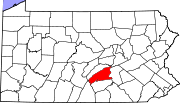
Perry County, Pennsylvania
As of the census of 2000, there were 43,602 people, 16,695 households, and 12,320 families residing in the county. The population density was 79 people per square mile . There were 18,941 housing units at an average density of 34 per square mile...
by the Pennsylvania Historical and Museum Commission
Pennsylvania Historical and Museum Commission
The Pennsylvania Historical and Museum Commission is the governmental agency of the Commonwealth of Pennsylvania responsible for the collection, conservation and interpretation of Pennsylvania's historic heritage...
(PHMC). The locations of the historical markers, as well as the latitude and longitude coordinates as provided by the PHMC's database, are included below when available. There are 15 historical markers located in Perry County.
Historical markers
| Marker title | Image | Date dedicated | Location | Marker type | Topics |
|---|---|---|---|---|---|
| Carson Long Military Institute Carson Long Military Institute Carson Long Military Academy, located in New Bloomfield, Pennsylvania, is the oldest boarding school in the United States that has military training. It features grades 6-12 with a maximum capacity of 180 cadets.-School history:... |
N. Carlisle St. at school, New Bloomfield °N °W |
Roadside | Education, Military, Military Post-Civil War | ||
| Centre Church | Junction Pa. 850 & Pa. 274, 2.1 miles W of Loysville (Missing) °N °W |
Roadside | Buildings, Early Settlement, Religion | ||
| Dr. Reifsnyder | U.S. 11 & 15, Liverpool 40.5735°N 76.9899°W |
Roadside | Medicine & Science, Professions & Vocations, Religion, Women | ||
| Fort Robinson | Junction Pa. 274 & 850, 2. 1miles W of Loysville 40.35867°N 77.38012°W |
Roadside | Forts, French & Indian War, Military, Native American | ||
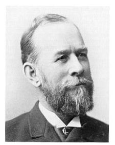
| James A. Beaver James A. Beaver James Addams Beaver was an American politician who served as the 20th Governor of Pennsylvania from 1887 to 1891... |
 |
Market & Sunbury Sts., in median at Sq., Millerstown 40.54955°N 77.15495°W |
Roadside | Civil War, Government & Politics, Government & Politics 19th Century, Governors, Military | |
| John Bannister Gibson John Bannister Gibson John Bannister Gibson was a Pennsylvania attorney and judge.-Early life:Born in Perry County, Pennsylvania, Gibson was named for John Banister, a Virginia hero of the American Revolution. Gibson's father, George Gibson, also fought in the war and remained in service after its end... |
Pa. 850, 1.2 miles W of Dromgold 40.3519°N 77.21167°W |
Roadside | Government & Politics, Government & Politics 19th Century, Governors | ||
| John Bannister Gibson - PLAQUE John Bannister Gibson John Bannister Gibson was a Pennsylvania attorney and judge.-Early life:Born in Perry County, Pennsylvania, Gibson was named for John Banister, a Virginia hero of the American Revolution. Gibson's father, George Gibson, also fought in the war and remained in service after its end... |
PA 850 at Mill Rd., 1 mile W of Dromgold °N °W |
Plaque | Government & Politics 19th Century, Professions & Vocations | ||
| Lightning Guider Sleds | 722 N. Market St., Duncannon 40.3981°N 77.02307°W |
Roadside | Business & Industry, Sports | ||
| Millersburg Ferry Millersburg Ferry Joseph Kramer, son of David Kramer, was granted by the Act of March 21, 1866 P.L. 358, the right to operate the ferry at his own expense. Part of the act stipulated that Kramer build and maintain landings on both shores of the river.... |
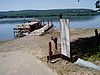 |
U.S. 11 & 15 S of Liverpool, near junction Pa. 34 40.5437°N 76.98773°W |
Roadside | Business & Industry, Oil & Gas, Transportation | |
| Pennsylvania Canal (Susquehanna Division) Pennsylvania Canal (Susquehanna Division) The only canal of the Susquehanna Division of the Pennsylvania Canal ran along the west bank of the main stem of the Susquehanna River between a lock near the mouth of the Juniata River and the canal basin at Northumberland... |
US 11 & 15 at Island Rd. (Haldeman Is. entrance), just N of Rt. 322 interchange, N of Duncannon °N °W |
Roadside | Canals, Government & Politics, Navigation, Railroads, Transportation | ||
| Pennsylvania Canal (Susquehanna Division) Pennsylvania Canal (Susquehanna Division) The only canal of the Susquehanna Division of the Pennsylvania Canal ran along the west bank of the main stem of the Susquehanna River between a lock near the mouth of the Juniata River and the canal basin at Northumberland... |
U.S. 11 & 15 just N of Amity Hall, Duncannon (MISSING) °N °W |
Roadside | Canals, Navigation, Transportation | ||
| Pennsylvania Canal (Susquehanna Division) Pennsylvania Canal (Susquehanna Division) The only canal of the Susquehanna Division of the Pennsylvania Canal ran along the west bank of the main stem of the Susquehanna River between a lock near the mouth of the Juniata River and the canal basin at Northumberland... |
U.S. 11 & 15 just N of Liverpool (MISSING) °N °W |
Roadside | Canals, Navigation, Transportation | ||
| Perry County Perry County, Pennsylvania As of the census of 2000, there were 43,602 people, 16,695 households, and 12,320 families residing in the county. The population density was 79 people per square mile . There were 18,941 housing units at an average density of 34 per square mile... |
County Courthouse, on Square, New Bloomfield 40.42°N 77.18687°W |
City | Government & Politics, Government & Politics 19th Century, Governors | ||
| Rockville Bridge Rockville Bridge The Rockville Bridge, at the time of its completion in 1902, was, and still remains, the longest stone masonry arch railroad viaduct in the world. Constructed between 1900 - 1902 by the Pennsylvania Railroad, it has forty-eight 70-foot spans, for a total length of 3,820 feet .The bridge crosses... |
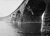 |
U.S. 11 & 15 at N end of Marysville °N °W |
Roadside | Bridges, Transportation | |
| William Bigler (1814-1880) William Bigler William Bigler was the 12th Governor of Pennsylvania from 1852 to 1855, and later a U.S. Senator for the Democratic Party.... |
Junction Pa. 34 & 850, Dromgold °N °W |
Roadside | Government & Politics, Government & Politics 19th Century, Governors |
See also
- List of Pennsylvania state historical markers
- National Register of Historic Places listings in Perry County, PennsylvaniaNational Register of Historic Places listings in Perry County, PennsylvaniaThis is a list of the National Register of Historic Places listings in Perry County, Pennsylvania.This is intended to be a complete list of the properties and districts on the National Register of Historic Places in Perry County, Pennsylvania, United States...