

List of Pennsylvania state historical markers in Lehigh County
Encyclopedia

This is intended to be a complete list of the official state historical markers placed in Lehigh County, Pennsylvania
Lehigh County, Pennsylvania
-Climate:Most of the county's climate is considered to fall in the humid continental climate zone. Summers are typically hot and muggy, fall and spring are generally mild, and winter is cold. Precipitation is almost uniformly distributed throughout the year....
by the Pennsylvania Historical and Museum Commission
Pennsylvania Historical and Museum Commission
The Pennsylvania Historical and Museum Commission is the governmental agency of the Commonwealth of Pennsylvania responsible for the collection, conservation and interpretation of Pennsylvania's historic heritage...
(PHMC). The locations of the historical markers, as well as the latitude and longitude coordinates as provided by the PHMC's database, are included below when available. There are 29 historical markers located in Lehigh County.
Historical markers
| Marker title | Image | Date dedicated | Location | Marker type | Topics |
|---|---|---|---|---|---|
| Abraham Blumer - PLAQUE | On grounds of Jordan United Church of Christ at Walbert, South Whitehall Twp. 40.61352°N 75.567°W |
Plaque | American Revolution, Ethnic & Immigration, Military, Religion | ||
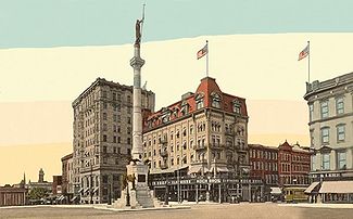
| Allentown Allentown, Pennsylvania Allentown is a city located in Lehigh County, Pennsylvania, in the United States. It is Pennsylvania's third most populous city, after Philadelphia and Pittsburgh, and the 215th largest city in the United States. As of the 2010 census, the city had a total population of 118,032 and is currently... |
 |
S 4th St. (PA 145), just S of W Mountain Rd., Allentown °N °W |
Roadside | Business & Industry, Cities & Towns, Government & Politics 18th Century | |
| Allentown Allentown, Pennsylvania Allentown is a city located in Lehigh County, Pennsylvania, in the United States. It is Pennsylvania's third most populous city, after Philadelphia and Pittsburgh, and the 215th largest city in the United States. As of the 2010 census, the city had a total population of 118,032 and is currently... |
 |
MacArthur Rd. (PA 145) at N city line, just N of Sumner Ave. overpass, Allentown °N °W |
Roadside | American Revolution, Business & Industry, Cities & Towns, Government & Politics | |
| Allentown Allentown, Pennsylvania Allentown is a city located in Lehigh County, Pennsylvania, in the United States. It is Pennsylvania's third most populous city, after Philadelphia and Pittsburgh, and the 215th largest city in the United States. As of the 2010 census, the city had a total population of 118,032 and is currently... |
Tilghman St. (old US 22) at 30th St., Allentown 40.6164°N 75.50678°W |
Roadside | American Revolution, Business & Industry, Cities & Towns, Government & Politics | ||
| Allentown Allentown, Pennsylvania Allentown is a city located in Lehigh County, Pennsylvania, in the United States. It is Pennsylvania's third most populous city, after Philadelphia and Pittsburgh, and the 215th largest city in the United States. As of the 2010 census, the city had a total population of 118,032 and is currently... |
 |
N 19th St. at Roth Ave., Allentown °N °W |
Roadside | American Revolution, Business & Industry, Cities & Towns, Government & Politics | |
| Allentown Allentown, Pennsylvania Allentown is a city located in Lehigh County, Pennsylvania, in the United States. It is Pennsylvania's third most populous city, after Philadelphia and Pittsburgh, and the 215th largest city in the United States. As of the 2010 census, the city had a total population of 118,032 and is currently... |
 |
U.S. 309 South at Allentown °N °W |
Roadside | American Revolution, Business & Industry, Cities & Towns, Government & Politics | |
| Biery's Port | Corner Race & Lehigh Sts., Catasauqua °N °W |
City | Business & Industry, Cities & Towns, Coal, Iron, Mills | ||
| Crane Iron Works Lehigh Crane Iron Company The Lehigh Crane Iron Company was a major ironmaking firm in the Lehigh Valley from its founding in 1839 until its sale in 1899. It was founded under the patronage of the Lehigh Coal and Navigation Company, which hoped to promote the then-novel technique of smelting iron ore with anthracite coal... |
Front St. between Church & Wood Sts., Catasauqua 40.65208°N 75.47287°W |
City | Business & Industry, Coal, Furnaces, Iron | ||
| David Thomas David Thomas (industrialist) David Thomas was a native of Wales who was influential in the birth of the Industrial Revolution in the US.-Development of the hot blast:David Thomas was born in Cadoxton, near Neath... |
Pine Street, Catasauqua 40.6551°N 75.47443°W |
City | Business & Industry, Coal, Entrepreneurs, Ethnic & Immigration, Iron | ||
| Dery Silk Mill | 101 Race Street, Catasauqua 40.64917°N 75.4677°W |
City | Buildings, Business & Industry, Mills | ||
| Emmaus Emmaus, Pennsylvania Emmaus is a borough in Lehigh County, Pennsylvania, in the United States. It is located five miles southwest of Allentown, Pennsylvania, in the Lehigh Valley region of the state.The population of Emmaus was 11,313 at the 2000 census... |
Main St. at library, Emmaus 40.54103°N 75.48653°W |
Roadside | Cities & Towns, Early Settlement, Native American, Religion | ||
| First Cement | Opposite Coplay Cement office bldg. at Coplay 40.67617°N 75.498°W |
Roadside | Business & Industry | ||
| First School Slate Factory | Main and Factory Sts., Slatington 40.75247°N 75.60805°W |
City | Business & Industry, Education | ||
| Fort Deshler Fort Deshler Fort Deshler, located near Egypt, Lehigh County, Pennsylvania, was a French and Indian War era frontier fort established in 1760 to protect settlers from Indian attacks... |
 |
Pa. 145 at Ironton Rail Trail 40.67227°N 75.51608°W |
Roadside | Forts, French & Indian War, Military | |
| Fort Everett | Pa. 143 E of Lynnport 40.67713°N 75.80095°W |
Roadside | Forts, French & Indian War, Military | ||
| Frederick Leaser - PLAQUE | Leaser Lake Park off PA 143 near Jacksonville, Lynnport 40.67078°N 75.83333°W |
Plaque | American Revolution | ||
| George Taylor (1716-1781) George Taylor (delegate) George Taylor was a Colonial ironmaster and a signer of the United States Declaration of Independence as a representative of Pennsylvania... |
.jpg) |
n/a | Lehigh St. just S of Race St., Catasaqua 40.64708°N 75.46683°W |
City | Government & Politics, Government & Politics 18th Century, Iron |
| Harriet A. Baker | 410 Union St., Allentown 40.60095°N 75.4641°W |
City | African American, Religion, Women | ||
| Indian Jasper Quarries | SR 2027 near intersection SR 2023, Vera Cruz 40.50732°N 75.49672°W |
City | Business & Industry, Native American | ||
| Lehigh County Lehigh County, Pennsylvania -Climate:Most of the county's climate is considered to fall in the humid continental climate zone. Summers are typically hot and muggy, fall and spring are generally mild, and winter is cold. Precipitation is almost uniformly distributed throughout the year.... |
Old Courthouse, 5th & Hamilton Sts., Allentown 40.60333°N 75.46803°W |
City | Government & Politics, Government & Politics 19th Century | ||
| Lock Ridge Iron Furnace | at Presbyterian church, 407 Franklin St. (at Church St.), Alburtis 40.5093°N 75.5982°W |
Roadside | Coal, Furnaces, Iron | ||
| Portland Cement | Iron Run Indus. Park., Tilghman St. (old U.S. 22), just W of Mill Rd. / Windsor Dr. intersection, W of Kuhnsville °N °W |
Roadside | Business & Industry | ||
| Samuel Wetherill (1821-1890) | North side of Columbia between Webster and Adams Sts., Bethlehem 40.61262°N 75.37651°W |
City | Business & Industry, Civil War, Invention, Medicine & Science, Military | ||
| Slate Industry Slate industry The slate industry is the industry related to the extraction and processing of slate. Slate is either quarried from a slate quarry or reached by tunneling in a slate mine. Common uses for slate include as a roofing material, a flooring material, gravestones and memorial tablets, and for electrical... |
Intersection of Main and Railroad Streets, Slatington 40.75298°N 75.60452°W |
Roadside | Business & Industry, Entrepreneurs, Ethnic & Immigration | ||
| Stephen Vincent Benet Stephen Vincent Benét Stephen Vincent Benét was an American author, poet, short story writer, and novelist. Benét is best known for his book-length narrative poem of the American Civil War, John Brown's Body , for which he won a Pulitzer Prize in 1929, and for two short stories, "The Devil and Daniel Webster" and "By... |
NE corner, Ostrum & Bishopthorpe Sts., Fountain Hill 40.60715°N 75.39382°W |
City | Writers | ||
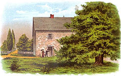
| Trout Hall |  |
S. 4th St. near walnut St., Allentown 40.60195°N 75.46467°W |
Roadside | Education, Government & Politics, Government & Politics 18th Century, Mansions & Manors, Religion | |
| Troxell-Steckel House | 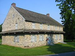 |
Main St. (PA 329) at Reliance St, beside church parking lot, Egypt 40.68092°N 75.52908°W |
Roadside | Buildings, Early Settlement, Houses & Homesteads | |
| Troxell-Steckel House | |
S Church St. (Rt. 1023) near Bridge St., Egypt 40.67923°N 75.52917°W |
Roadside | Buildings, Early Settlement, Houses & Homesteads | |
| Trucker's Mill | Main St. (Pa. 873) near Diamond St., Slatington 40.75278°N 75.61043°W |
City | Forts, French & Indian War, Military, Mills, Roads |
See also
- List of Pennsylvania state historical markers
- National Register of Historic Places listings in Lehigh County, PennsylvaniaNational Register of Historic Places listings in Lehigh County, PennsylvaniaThis is a list of the National Register of Historic Places listings in Lehigh County, Pennsylvania.This is intended to be a complete list of the properties and districts on National Register of Historic Places in Lehigh County, Pennsylvania...