

List of Pennsylvania state historical markers in Juniata County
Encyclopedia
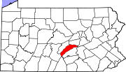
This is intended to be a complete list of the official state historical markers placed in Juniata County, Pennsylvania
Juniata County, Pennsylvania
Juniata County is a county located in the U.S. state of Pennsylvania. As of 2010, the population was 24,636. Juniata County was created on March 2, 1831, from part of Mifflin County and named for the Juniata River. Its county seat is Mifflintown....
by the Pennsylvania Historical and Museum Commission
Pennsylvania Historical and Museum Commission
The Pennsylvania Historical and Museum Commission is the governmental agency of the Commonwealth of Pennsylvania responsible for the collection, conservation and interpretation of Pennsylvania's historic heritage...
(PHMC). The locations of the historical markers, as well as the latitude and longitude coordinates as provided by the PHMC's database, are included below when available. There are five historical markers located in Juniata County.
Historical markers
| Marker title | Image | Date dedicated | Location | Marker type | Topics |
|---|---|---|---|---|---|
| Fort Bigham | SR 3001 (old U.S. 22 & 322), .8 mile NW of Mexico 40.5467°N 77.36633°W |
Roadside | Forts, French & Indian War, Military, Native American | ||
| Juniata County Juniata County, Pennsylvania Juniata County is a county located in the U.S. state of Pennsylvania. As of 2010, the population was 24,636. Juniata County was created on March 2, 1831, from part of Mifflin County and named for the Juniata River. Its county seat is Mifflintown.... |
County Courthouse, Mifflintown 40.5702°N 77.56293°W |
City | Government & Politics, Government & Politics 19th Century, Transportation | ||
| Patterson's Fort | Wm. Penn Hwy. (SR 3001 / old US 22/322), near Gill Rd. (Rt. 382), .1 mile E of Mexico 40.5359°N 77.35072°W |
Roadside | French & Indian War, Military, Native American | ||
| Tuscarora Academy Tuscarora Academy The Tuscarora Academy in Mifflintown, Pennsylvania is a building from 1816. It was listed on the National Register of Historic Places in 1972.... |
At site, SR 3017 (former LR 34005), Academia °N °W |
Roadside | Education, Religion | ||
| Tuscarora Path | Wm. Penn Hwy. (SR 3002 / old US 22/322) near Henry Crossroad Rd. (PA 75), .9 mile NW of Mexico 40.54757°N 77.36793°W |
Roadside | Native American, Paths & Trails, Transportation |
See also
- List of Pennsylvania state historical markers
- National Register of Historic Places listings in Juniata County, PennsylvaniaNational Register of Historic Places listings in Juniata County, PennsylvaniaThis is a list of the National Register of Historic Places listings in Juniata County, Pennsylvania.This is intended to be a complete list of the properties and districts on the National Register of Historic Places in Juniata County, Pennsylvania, United States...