

List of Pennsylvania state historical markers in Centre County
Encyclopedia
This is intended to be a complete list of the official state historical markers placed in Centre County, Pennsylvania
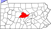
Centre County, Pennsylvania
Centre County is a county located in the U.S. state of Pennsylvania. It is part of the State College, Pennsylvania Metropolitan Statistical Area. As of 2010, the population was 153,990....
by the Pennsylvania Historical and Museum Commission
Pennsylvania Historical and Museum Commission
The Pennsylvania Historical and Museum Commission is the governmental agency of the Commonwealth of Pennsylvania responsible for the collection, conservation and interpretation of Pennsylvania's historic heritage...
(PHMC). The locations of the historical markers, as well as the latitude and longitude coordinates as provided by the PHMC's database, are included below when available. There are 29 historical markers located in Centre County.
Historical markers
| Marker title | Image | Date dedicated | Location | Marker type | Topics |
|---|---|---|---|---|---|
| 28th Division Shrine | Business U.S. 322 at Pa. Military Museum, Boalsburg 40.78028°N 77.79723°W |
Roadside | Government & Politics, Military, Military Post-Civil War | ||
| Aaronsburg Story, The Aaronsburg, Pennsylvania Aaronsburg is a census-designated place in Centre County, Pennsylvania, United States. It is part of the State College, Pennsylvania Metropolitan Statistical Area. The population was 613 at the 2010 census.-History:... |
Pa. 45, E end of Aaronsburg °N °W |
Roadside | African American, Ethnic & Immigration, Religion | ||
| Andrew G. Curtin Andrew Gregg Curtin Andrew Gregg Curtin was a U.S. lawyer and politician. He served as the Governor of Pennsylvania during the Civil War.-Biography:... |
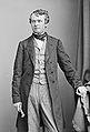 |
Allegheny St. at Cherry Lane, Bellefonte °N °W |
City | Education, Government & Politics, Government & Politics 19th Century, Governors | |
| Anna Wagner Keichline | 126 West High Street, Bellefonte 40.91182°N 77.77873°W |
City | Buildings, Invention, Military, Military Post-Civil War, Professions & Vocations, Women | ||
| Bald Eagle's Nest | U.S. 220 & Pa. 114 at Milesburg 40.943°N 77.78678°W |
Roadside | Native American | ||
| Bellefonte Bellefonte, Pennsylvania Bellefonte is a borough in Centre County, Pennsylvania, United States. It lies about twelve miles northeast of State College and is part of the State College, Pennsylvania Metropolitan Statistical Area... |
PA 150 at south end of town, near Reynolds Ave., Bellefonte 40.912°N 77.77808°W |
Roadside | Cities & Towns | ||
| Bellefonte Air Mail Field | Pa. 550 (E. Bishop St.) at high school, Bellefonte 40.91407°N 77.7617°W |
Roadside | Business & Industry, Transportation | ||
| Centre County Centre County, Pennsylvania Centre County is a county located in the U.S. state of Pennsylvania. It is part of the State College, Pennsylvania Metropolitan Statistical Area. As of 2010, the population was 153,990.... |
County Courthouse, Allegheny St. at High St., Bellefonte 40.9122°N 77.77773°W |
City | Education, Government & Politics, Government & Politics 19th Century | ||
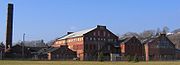
| Centre Furnace | Porter Road, 150 feet north of East College Avenue (Pa. 26), State College 40.80605°N 77.84337°W |
Roadside | Business & Industry, Coal, Furnaces, Iron | ||
| Centre Furnace - PLAQUE | Centre Furnace Mansion, 1001 E. College Ave. (PA 26), State College °N °W |
Plaque | American Revolution, Furnaces, Iron, Military | ||
| Eagle Ironworks | Pa. 150 (former U.S. 220) 2.8 miles NE of Milesburg 40.97633°N 77.74328°W |
Roadside | Business & Industry, Iron | ||
| Great Shamokin Path Great Shamokin Path The Great Shamokin Path was a major Native American trail in the U.S. State of Pennsylvania that ran from the native village of Shamokin along the left bank of the West Branch Susquehanna River north and then west to the Great Island... |
Pa. 150, 4 miles NE of Howard 41.06002°N 77.6183°W |
Roadside | Native American, Paths & Trails, Transportation | ||
| Indian Paths | Pa. 350 S of Philipsburg (Missing) °N °W |
Roadside | Native American | ||
| John I. Thompson Grain Elevator and Coal Sheds | 137 Mt. Nittany Rd., Lemont, across from grain elevator 40.8103°N 77.81733°W |
Roadside | Agriculture, Buildings, Coal, Education, Railroads, Transportation | ||
| John Montgomery Ward John Montgomery Ward John Montgomery Ward , known as Monte Ward, was an American Major League Baseball pitcher, shortstop and manager. Ward was born in Bellefonte, Pennsylvania, and grew up in Renovo, Pennsylvania... |
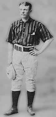 |
236 East Lamb St., Bellefonte 40.91572°N 77.77643°W |
City | Baseball, Labor, Sports | |
| Juniata Iron | US 220 ~1.3 miles SW of Unionville at Barr Lane °N °W |
Roadside | Business & Industry, Coal, Iron | ||
| Juniata Iron | US 220 near US 322, north side, 1.8 miles NE of Port Matilda 40.82597°N 78.02292°W |
Roadside | Business & Industry, Coal, Iron | ||
| Mills Brothers, The Mills Brothers The Mills Brothers, sometimes billed as The Four Mills Brothers, were an American jazz and pop vocal quartet of the 20th century who made more than 2,000 recordings that combined sold more than 50 million copies, and garnered at least three dozen gold records... |
213 W. High St., between Water & Spring, Bellefonte 40.91167°N 77.78007°W |
City | African American, Business & Industry, Performers | ||
| Pennsylvania Match Factory Pennsylvania Match Company The Pennsylvania Match Company, known locally as the Match Factory, was founded in 1899 by Col. W. Fred Reynolds, Joseph T. Montgomery and S. A. Donachy with $200,000 of their own money.Mr... |
 |
Willowbank St. (PA 150) at Phoenix Ave., Bellefonte 40.90792°N 77.78195°W |
Roadside | Business & Industry, Entrepreneurs, Labor | |
| Pennsylvania State University, The Pennsylvania State University The Pennsylvania State University, commonly referred to as Penn State or PSU, is a public research university with campuses and facilities throughout the state of Pennsylvania, United States. Founded in 1855, the university has a threefold mission of teaching, research, and public service... |
 |
Atherton St. (Bus. US 322) between Curtin Rd. & W Park Ave., State College 40.7962°N 77.8712°W |
Roadside | Agriculture, Education | |
| Philip Benner | E College Ave. (Rt. 26), at Shiloh Rd., NE of State College (near Dale Summit) 40.8343°N 77.79645°W |
Roadside | Business & Industry, Government & Politics, Iron | ||
| Philip Benner | Buffalo Run Rd. (Rt. 550) at Rock Rd., at Buffalo Run Church, just S of Bellefonte 40.8747°N 77.8474°W |
Roadside | Business & Industry, Government & Politics, Iron | ||
| Plumbe Forge | Pa. 504, 6 miles E of Philipsburg 40.9091°N 78.1045°W |
Roadside | Business & Industry, Iron | ||
| Potter's Fort | S Pennsylvania Ave. (PA 144) at S Miles Alley, SE of Centre Hall 40.83892°N 77.777°W |
Roadside | American Revolution, Military | ||
| Scotia | off the Gray's Woods exit of US 220/322, on Gray's Woods Blvd. / Scotia Rd., NW of State College in Patton Twp. 40.81362°N 77.94072°W |
Roadside | Business & Industry, Iron, Railroads | ||
| Union Cemetery Union Cemetery (Bellefonte, Pennsylvania) Union Cemetery located on East Howard Street in Bellefonte, Pennsylvania was established in 1795. Burials occurred as early as 1808, and the cemetery itself was chartered in 1856. It is the final resting place of Bellefonte's founding families, Pennsylvania Governors and their wives, U.S... |
At entrance at E Howard St., near Cowdrick Alley, Bellefonte 40.91436°N 77.77383°W |
Roadside | Government & Politics, Government & Politics 19th Century, Governors, Religion | ||
| Union Church Union Church and Burial Ground Union Church and Burial Ground is a historic church and cemetery on E. Presqueisle Street in Philipsburg, Pennsylvania.... |
Presqueisle St. (US 322) near N 7th St., Philipsburg 40.8982°N 78.2173°W |
City | Education, Religion | ||
| Warriors Path | N Eagle Valley Rd. (PA 150) near Walnut St. (PA 26), 2.2 miles NE of Howard 41.02515°N 77.66613°W |
Roadside | Native American, Paths & Trails, Transportation | ||
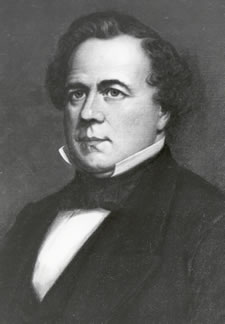
| William F. Packer William F. Packer William Fisher Packer was the 14th Governor of Pennsylvania from 1858 to 1861. His father was James Packer from Chester County, Pennsylvania and his mother was Charity Packer. His ancestry was primarily Quakers from Philadelphia... |
 |
N Eagle Valley Rd. (PA 150) at Walnut St. (PA 26), Howard 41.02165°N 77.67025°W |
Roadside | Government & Politics, Government & Politics 19th Century, Governors, Professions & Vocations, Publishing, Transportation |
See also
- List of Pennsylvania state historical markers
- National Register of Historic Places listings in Centre County, PennsylvaniaNational Register of Historic Places listings in Centre County, PennsylvaniaThis is a list of the National Register of Historic Places listings in Centre County, Pennsylvania.This is intended to be a complete list of the properties and districts on the National Register of Historic Places in Centre County, Pennsylvania, United States...