

List of Pennsylvania state historical markers in Butler County
Encyclopedia
This is intended to be a complete list of the official state historical markers placed in Butler County, Pennsylvania
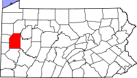
Butler County, Pennsylvania
-Demographics:As of the census of 2000, there were 174,083 people, 65,862 households, and 46,827 families residing in the county. The population density was 221 people per square mile . There were 69,868 housing units at an average density of 89 per square mile...
by the Pennsylvania Historical and Museum Commission
Pennsylvania Historical and Museum Commission
The Pennsylvania Historical and Museum Commission is the governmental agency of the Commonwealth of Pennsylvania responsible for the collection, conservation and interpretation of Pennsylvania's historic heritage...
(PHMC). The locations of the historical markers, as well as the latitude and longitude coordinates as provided by the PHMC's database, are included below when available. There are 15 historical markers located in Butler County.
Historical markers
| Marker title | Image | Date dedicated | Location | Marker type | Topics |
|---|---|---|---|---|---|
| Butler County Butler County, Pennsylvania -Demographics:As of the census of 2000, there were 174,083 people, 65,862 households, and 46,827 families residing in the county. The population density was 221 people per square mile . There were 69,868 housing units at an average density of 89 per square mile... |
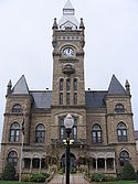 |
County Courthouse, Main St. (Pa. 8), Butler 40.85857°N 79.89545°W |
City | George Washington, Government & Politics, Government & Politics 19th Century, Religion | |
| General Richard Butler - PLAQUE Richard Butler (general) Richard Butler was an officer in the Continental Army in the American Revolutionary War, who later died fighting American Indians in Ohio.-Early life:... |
County Courthouse, Butler 40.85857°N 79.89545°W |
Plaque | American Revolution, Ethnic & Immigration, Military | ||
| George Edward Waddell Rube Waddell George Edward Waddell was an American southpaw pitcher in Major League Baseball. In his thirteen-year career he played for the Louisville Colonels , Pittsburgh Pirates and Chicago Orphans in the National League, and the Philadelphia Athletics and St. Louis Browns in the American League... |
Route 488, next to Fire Hall, Prospect °N °W |
Roadside | Baseball, Sports | ||
| George Washington George Washington George Washington was the dominant military and political leader of the new United States of America from 1775 to 1799. He led the American victory over Great Britain in the American Revolutionary War as commander-in-chief of the Continental Army from 1775 to 1783, and presided over the writing of... |
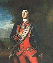 |
Pa. 68, 1.8 miles NE of Evans City (Missing) °N °W |
Roadside | Forts, French & Indian War, George Washington, Military, Native American | |
| Harmonist Cemetery | Pa. 68 in Harmony 40.80177°N 80.1237°W |
Roadside | Religion | ||
| Harmony Harmony Society The Harmony Society was a Christian theosophy and pietist society founded in Iptingen, Germany, in 1785. Due to religious persecution by the Lutheran Church and the government in Württemberg, the Harmony Society moved to the United States on October 7, 1803, initially purchasing of land in Butler... |
 |
Main St. at Mercer St. in Harmony 40.80267°N 80.12785°W |
Roadside | Religion | |
| Harmony Mennonites | U.S. 19 N of Zelienople 40.80927°N 80.12942°W |
Roadside | Religion | ||
| Invention of the Jeep | 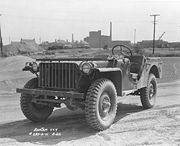 |
Hansen Ave. in Butler 40.85713°N 79.9116°W |
Roadside | Business & Industry, Military, Military Post-Civil War, Transportation | |
| Old Stone House | At site, Pa. 8 at junction Pa. 173, Stone House °N °W |
Roadside | Buildings, Business & Industry, Houses & Homesteads | ||
| Old Stone House | At site, Pa. 8 at junction Pa. 173, Stone House °N °W |
Roadside | Buildings, Business & Industry, Houses & Homesteads | ||
| Rev. Richard C. Christy | At church, 455 Clearfield Road, Fenelton °N °W |
Roadside | Civil War, Religion | ||
| Roeblings, The John A. Roebling John Augustus Roebling was a German-born American civil engineer. He is famous for his wire rope suspension bridge designs, in particular, the design of the Brooklyn Bridge.-Early life:... |
Butler Rd. (SR 2010) near High St., Saxonburg 40.75503°N 79.81798°W |
Roadside | Bridges, Business & Industry, Invention, Professions & Vocations, Transportation | ||
| Venango Path Venango Path Venango Path was a Native American trail that ran from the Forks of the Ohio to Presque Isle, Pennsylvania, United States of America. The trail was named after the Native American village of Venango where French Creek empties into the Allegheny River... |
 |
Franklin Rd. at Mars Crider Rd. (Rt. 228), Cranberry Twp. 40.6856°N 80.07512°W |
Roadside | Forts, George Washington, Military, Native American, Paths & Trails, Roads, Transportation | |
| William A. Smith | N Pike Rd. (PA 356) between Saxonburg and Marwood, 9 miles SE of Butler 40.7684°N 79.78732°W |
Roadside | Business & Industry, Oil & Gas, Professions & Vocations | ||
| Zelienople Zelienople, Pennsylvania Zelienople is a borough in Butler County, Pennsylvania, north of Pittsburgh. The population was 4,123 at the 2000 census.-Geography:According to the United States Census Bureau, the borough has a total area of , of which 98% is land and 1.35% is water.... |
N Main St./ Perry Hwy. (US 19) just N of Zelienople 40.8°N 80.13795°W |
Roadside | Buildings, Cities & Towns |
See also
- List of Pennsylvania state historical markers
- National Register of Historic Places listings in Butler County, PennsylvaniaNational Register of Historic Places listings in Butler County, PennsylvaniaThis is a list of the National Register of Historic Places listings in Butler County, Pennsylvania.This is intended to be a complete list of the properties and districts on the National Register of Historic Places in Butler County, Pennsylvania, United States...