

List of Pennsylvania state historical markers in Blair County
Encyclopedia
This is intended to be a complete list of the official state historical markers placed in Blair County, Pennsylvania
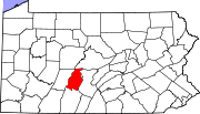
Blair County, Pennsylvania
-Significant Topographic Features:*Brush Mountain*Logan Valley*Morrison Cove*Tussey Mountain-Demographics:As of the census of 2000, there were 129,144 people, 51,518 households, and 34,877 families residing in the county. The population density was 246 people per square mile . There were 55,061...
by the Pennsylvania Historical and Museum Commission
Pennsylvania Historical and Museum Commission
The Pennsylvania Historical and Museum Commission is the governmental agency of the Commonwealth of Pennsylvania responsible for the collection, conservation and interpretation of Pennsylvania's historic heritage...
(PHMC). The locations of the historical markers, as well as the latitude and longitude coordinates as provided by the PHMC's database, are included below when available. There are 27 historical markers located in Blair County.
Historical markers
| Marker title | Image | Date dedicated | Location | Marker type | Topics |
|---|---|---|---|---|---|
| Allegheny Furnace Allegheny Furnace Allegheny Furnace is a historic iron furnace located at Altoona, Blair County, Pennsylvania. The furnace was built in 1811, with alterations and additions built in 1847 and 1852.It was added to the National Register of Historic Places in 1991.... |
Pa. 36 (Union Ave.) S of 31st St., Altoona 40.49207°N 78.40655°W |
Roadside | Business & Industry, Furnaces, Iron | ||
| Altoona Altoona, Pennsylvania -History:A major railroad town, Altoona was founded by the Pennsylvania Railroad in 1849 as the site for a shop complex. Altoona was incorporated as a borough on February 6, 1854, and as a city under legislation approved on April 3, 1867, and February 8, 1868... |
 |
Logan Blvd., leading into Altoona 40.47846°N 78.40379°W |
Roadside | Cities & Towns, Government & Politics, Government & Politics 19th Century, Railroads | |
| Altoona Conference War Governors' Conference The Loyal War Governors' Conference was an important political event of the American Civil War. It was held at the Logan House Hotel in Altoona, Pennsylvania on September 24 and 25, 1862. Thirteen governors of Union states came together to discuss the war effort, state troop quotas, and the... |
U.S. 22 between Hollidaysburg and Duncansville (Missing) °N °W |
Roadside | Abraham Lincoln, African American, Government & Politics, Government & Politics 19th Century | ||
| Baker Mansion Baker Mansion Baker Mansion is a historic home located at Altoona, Blair County, Pennsylvania. It was built between 1844 and 1848, and is a three story, dressed stone building in the Greek Revival style. The front facade is five bays wide and features six fluted Ionic order columns... |
Pa. 36 (Union Ave.) at Mansion Blvd., Altoona 40.48792°N 78.40499°W |
Roadside | Buildings, Iron, Mansions & Manors | ||
| Baker Mansion Baker Mansion Baker Mansion is a historic home located at Altoona, Blair County, Pennsylvania. It was built between 1844 and 1848, and is a three story, dressed stone building in the Greek Revival style. The front facade is five bays wide and features six fluted Ionic order columns... |
n/a | Baker Blvd. and Mansion Ave., Altoona 40.48901°N 78.40804°W |
City | Buildings, Iron, Mansions & Manors | |
| Blair County Blair County, Pennsylvania -Significant Topographic Features:*Brush Mountain*Logan Valley*Morrison Cove*Tussey Mountain-Demographics:As of the census of 2000, there were 129,144 people, 51,518 households, and 34,877 families residing in the county. The population density was 246 people per square mile . There were 55,061... |
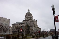
Courthouse, 423 Allegheny St., Hollidaysburg 40.43007°N 78.39243°W |
City | Government & Politics, Government & Politics 19th Century, Railroads | ||
| Blair Homestead | Twp. Road (old William Penn Hwy.), 1.6 miles W of Duncansville 40.41455°N 78.46279°W |
Roadside | Government & Politics, Government & Politics 18th Century, Houses & Homesteads | ||
| Blair Homestead | SR 3012 (old U.S. 22), 1.4 miles W of Duncansville (MISSING) 40.41454°N 78.41454°W |
Roadside | Government & Politics, Government & Politics 18th Century, Houses & Homesteads | ||
| Canal Basin Canal basin A canal basin is an expanse of waterway alongside or at the end of a canal, and wider than the canal, constructed to allow boats to moor or unload cargo without impeding the progress of other traffic, and to allow room for turning, thus serving as a winding hole... |
U.S. 22 at Canal Basin Park, W end of Hollidaysburg 40.42782°N 78.39646°W |
Roadside | Canals, Navigation, Railroads, Transportation | ||
| Daniel Hale Williams Daniel Hale Williams Daniel Hale Williams was an American surgeon. He was the first African-American cardiologist,and performed one of the first successful open-heart surgeries in the United States. He also founded Provident Hospital, the first non-segregated hospital in the United States.-Career:Williams was among... |
U.S. 22 eastbound (Blair St., 300 block), Hollidaysburg 40.42802°N 78.39221°W |
City | African American, Medicine & Science, Professions & Vocations | ||
| Etna Furnace | Int. of Etna Furnace Rd, TR 463 and Wm. Penn Hwy. (Missing) 40.52575°N 78.19975°W |
Roadside | Business & Industry, Furnaces, Iron | ||
| Fort Roberdeau Fort Roberdeau Fort Roberdeau, also known as The Lead Mine Fort, is a historic fort located near Culp, Blair County, Pennsylvania. It was built in 1777, and reconstructed in 1939-1941, by concerned local agencies with support from the National Youth Administration. It is a square structure with blockhouse-like... |
On Skelp Mountain Rd., off I-99 (US 220), E of Bellwood exit °N °W |
Roadside | American Revolution, Forts, Military | ||
| Fort Roberdeau Fort Roberdeau Fort Roberdeau, also known as The Lead Mine Fort, is a historic fort located near Culp, Blair County, Pennsylvania. It was built in 1777, and reconstructed in 1939-1941, by concerned local agencies with support from the National Youth Administration. It is a square structure with blockhouse-like... |
at site - Kettle Road (SR 1013), 1 mile SW of Culp (Missing) 40.57526°N 78.26807°W |
Roadside | American Revolution, Forts, Military | ||
| Frankstown | US 22, .6 mile E of Hollidaysburg, and SW of Frankstown 40.43288°N 78.36651°W |
Roadside | Cities & Towns, Native American, Paths & Trails | ||
| Fred Waring (1900 - 1984) Fred Waring Fredrick Malcolm Waring was a popular musician, bandleader and radio-television personality, sometimes referred to as "America's Singing Master" and "The Man Who Taught America How to Sing." He was also a promoter, financial backer and namesake of the Waring Blendor, the first modern electric... |
 |
SE corner of Pennsylvania Ave. & 11th St., Tyrone °N °W |
City | Music & Theater, Performers | |
| Gallitzin Spring | SR 3012 eastbound (old U.S. 22) 1 mile E of Cresson 40.44576°N 78.52648°W |
Roadside | Early Settlement, Religion | ||
| Gallitzin Spring | SR 3012 westbound (old U.S. 22) 1 mile E of Cresson 40.44576°N 78.52648°W |
Roadside | Early Settlement, Religion | ||
| Harold L. Ickes Harold L. Ickes Harold LeClair Ickes was a United States administrator and politician. He served as United States Secretary of the Interior for 13 years, from 1933 to 1946, the longest tenure of anyone to hold the office, and the second longest serving Cabinet member in U.S. history next to James Wilson. Ickes... |
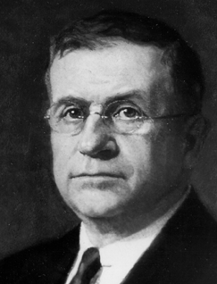 |
Altoona Area High School, 1415 Sixth Ave., Altoona 40.50962°N 78.39862°W |
City | Civil Rights, Environment, Government & Politics, Government & Politics 20th Century | |
| Isaac Charles Mishler | 1208 Twelfth Ave. at Mishler Theater Mishler Theatre The Mishler Theatre is a Beaux-Arts stage and movie theater located at 1208 Twelfth Avenue in Altoona, Pennsylvania. It was designed by Albert E. Westover and built by local theatre owner and manager Isaac Charles Mishler and opened on February 15, 1906. Nine months later, the neighboring Rothert... , Altoona 40.51616°N 78.4022°W |
City | Business & Industry, Music & Theater | ||
| Juniata Iron | SR 3012 (old U.S. 22), 2 miles W of Duncansville (Missing) °N °W |
Roadside | Coal, Iron | ||
| Juniata Iron | SR 3012 (old U.S. 22), 2 miles W of Duncansville (Missing) °N °W |
Roadside | Environment | ||
| Leap-The-Dips Roller Coaster Leap-The-Dips Leap-The-Dips is the world's oldest operating wooden roller coaster and North America's last surviving side friction roller coaster. It is located at Lakemont Park in Altoona, Pennsylvania and was built in 1902 by the E. Joy Morris Company. Leap-the-Dips operated until 1985, when it closed due to... |
Lakemont Park Lakemont Park Lakemont Park, located in Altoona, Pennsylvania, houses the world's oldest-surviving roller coaster, the Leap-The-Dips. The park opened in 1894 as a trolley park and became an amusement park in the summer of 1899. It is the 8th oldest in the United States... 700 Park Ave., Altoona 40.47081°N 78.39357°W |
City | Sports | ||
| Logan House | 11th Ave. at 13th St., Altoona 40.51502°N 78.40168°W |
Roadside | Abraham Lincoln, African American, Business & Industry, Government & Politics, Government & Politics 19th Century, Governors, Inns & Taverns | ||
| Lowry Homestead | U.S. 22, 1.1 miles E of Hollidaysburg (Missing) °N °W |
Roadside | Buildings, Houses & Homesteads, Native American, Paths & Trails | ||
| Pennsylvania Railroad Shops Altoona Works Altoona Works is a large railroad industrial complex in Altoona, Pennsylvania. It was built by the Pennsylvania Railroad to supply the railroad with locomotives, railroad cars and related equipment. For many years it was the largest railroad shop complex in the world.-History:In 1849, PRR... |
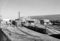 |
9th Ave. at 13th St., Altoona 40.51321°N 78.39985°W |
City | Business & Industry, Railroads, Transportation | |
| Portage Railroad Allegheny Portage Railroad The Allegheny Portage Railroad was the first railroad constructed through the Allegheny Mountains in central Pennsylvania, United States. It was a series of 10 inclines, approximately long, and operated from 1834 to 1854... |
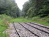 |
(SR 3012 / old US 22) westbound, just E of Cambria Co. line 40.45331°N 78.5429°W |
Roadside | Canals, Railroads, Transportation | |
| Portage Railroad Allegheny Portage Railroad The Allegheny Portage Railroad was the first railroad constructed through the Allegheny Mountains in central Pennsylvania, United States. It was a series of 10 inclines, approximately long, and operated from 1834 to 1854... |
 |
(SR 3012 / old US 22) eastbound, just E of Cambria Co. line °N °W |
Roadside | Canals, Railroads, Transportation |
See also
- List of Pennsylvania state historical markers
- National Register of Historic Places listings in Blair County, PennsylvaniaNational Register of Historic Places listings in Blair County, PennsylvaniaThis is a list of the National Register of Historic Places listings in Blair County, Pennsylvania.This is intended to be a complete list of the properties and districts on the National Register of Historic Places in Blair County, Pennsylvania, United States...