

List of Pennsylvania state historical markers in Armstrong County
Encyclopedia
This is intended to be a complete list of the official state historical markers placed in Armstrong County, Pennsylvania
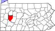
Armstrong County, Pennsylvania
Armstrong County is a county located in the U.S. state of Pennsylvania. As of the 2010 census, the population was 68,941. It is located northeast of Pittsburgh and Allegheny County. Armstrong County was added to the Pittsburgh Metropolitan Statistical Area in 2003.The county seat is Kittanning...
by the Pennsylvania Historical and Museum Commission
Pennsylvania Historical and Museum Commission
The Pennsylvania Historical and Museum Commission is the governmental agency of the Commonwealth of Pennsylvania responsible for the collection, conservation and interpretation of Pennsylvania's historic heritage...
(PHMC). The locations of the historical markers, as well as the latitude and longitude coordinates as provided by the PHMC's database, are included below when available. There are 11 historical markers located in Armstrong County.
Historical markers
| Marker title | Image | Date dedicated | Location | Marker type | Topics |
|---|---|---|---|---|---|
| Armstrong County Armstrong County, Pennsylvania Armstrong County is a county located in the U.S. state of Pennsylvania. As of the 2010 census, the population was 68,941. It is located northeast of Pittsburgh and Allegheny County. Armstrong County was added to the Pittsburgh Metropolitan Statistical Area in 2003.The county seat is Kittanning... |
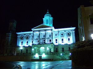 |
Courthouse, N. end Market St., Kittanning 40.81598°N 79.5164°W |
City | French & Indian War, Government & Politics, Government & Politics 19th Century, Invention, Military, Native American | |
| Blanket Hill Kittanning Expedition The Kittanning Expedition, also known as the Armstrong Expedition or the Battle of Kittanning, was a raid during the French and Indian War that led to the destruction of the American Indian village of Kittanning, which had served as a staging point for attacks by Delaware warriors against... |
U.S. 422, 6.5 miles SE of Kittanning 40.76488°N 79.41666°W |
Roadside | French & Indian War, Military, Native American | ||
| Brady's Bend Works | Pa. 68 Brady's Bend, at Allegheny River Bridge °N °W |
Roadside | Business & Industry, Iron, Transportation | ||
| Fort Armstrong | Pa. 66, 1.8 miles S of Kittanning (Missing) °N °W |
Roadside | American Revolution, Forts, Military | ||
| General John Armstrong - PLAQUE | mounted on Armstrong Co. Courthouse at entrance, N end of Market St., Kittanning 40.81612°N 79.5165°W |
Plaque | American Revolution, Ethnic & Immigration, Military | ||
| Kittanning Kittanning (village) Kittanning was an 18th century Native American village in the Ohio Country, located on the Allegheny River at present-day Kittanning, Pennsylvania. The village was at the western terminus of the Kittanning Path, an Indian trail that provided a route across the Alleghenies between the Ohio and... |
Butler Rd. (Bus. Rt. 422) & Allegheny Ave., at bridge, Applewold 40.8116°N 79.52406°W |
Roadside | Early Settlement, French & Indian War, Military, Native American | ||
| Kittanning Kittanning (village) Kittanning was an 18th century Native American village in the Ohio Country, located on the Allegheny River at present-day Kittanning, Pennsylvania. The village was at the western terminus of the Kittanning Path, an Indian trail that provided a route across the Alleghenies between the Ohio and... |
At Highway garage on US 422 (S Water Street), Kittanning 40.8084°N 79.51573°W |
Roadside | Early Settlement, Native American | ||
| Kittanning or Attique Indian Town - PLAQUE Kittanning (village) Kittanning was an 18th century Native American village in the Ohio Country, located on the Allegheny River at present-day Kittanning, Pennsylvania. The village was at the western terminus of the Kittanning Path, an Indian trail that provided a route across the Alleghenies between the Ohio and... |
At park on E bank of Allegheny River, adjacent to bridge, N. Water & Market Sts., Kittanning 40.81358°N 79.52127°W |
Plaque | Early Settlement, Native American | ||
| Nellie Bly Nellie Bly Nellie Bly was the pen name of American pioneer female journalist Elizabeth Jane Cochran. She remains notable for two feats: a record-breaking trip around the world in emulation of Jules Verne's character Phileas Fogg, and an exposé in which she faked insanity to study a mental institution from... |
 |
500 Terrace, Apollo °N °W |
City | Professions & Vocations, Publishing, Women | |
| Pittsburgh Plate Glass Ford City Works | Third Ave. at Ninth St., Ford City 40.77055°N 79.533°W |
City | Business & Industry, Ethnic & Immigration, Glass, Labor | ||
| St. Patrick's Church St. Patrick's Roman Catholic Church (Cowansville, Pennsylvania) St. Patrick's Roman Catholic Church is a historic church in Cowansville, Pennsylvania.The log building was constructed in 1805 and added to the National Register of Historic Places in 1978.-References:... |
E Brady Rd. (PA 268), ~4 miles NW of Cowansville 40.95155°N 79.65895°W |
Roadside | Buildings, Religion |
See also
- List of Pennsylvania state historical markers
- National Register of Historic Places listings in Armstrong County, PennsylvaniaNational Register of Historic Places listings in Armstrong County, PennsylvaniaThis is a list of the National Register of Historic Places listings in Armstrong County, Pennsylvania.This is intended to be a complete list of the properties and districts on the National Register of Historic Places in Armstrong County, Pennsylvania, United States...