

List of Ottawa, Ontario parks
Encyclopedia
This is a list of notable park
s in the City of Ottawa
, Ontario, Canada. Some of the major parks in Gatineau
, Quebec, which attract many people from Ottawa, are included.
Alta Vista
Blossom Park
Centretown
Civic Hospital
The Glebe
Kitchisippi
Lower Town
Manotick
Metcalfe
Old Ottawa South
Riverview
Riverside Park
Sandy Hill
Vanier
Park
A park is a protected area, in its natural or semi-natural state, or planted, and set aside for human recreation and enjoyment, or for the protection of wildlife or natural habitats. It may consist of rocks, soil, water, flora and fauna and grass areas. Many parks are legally protected by...
s in the City of Ottawa
Ottawa
Ottawa is the capital of Canada, the second largest city in the Province of Ontario, and the fourth largest city in the country. The city is located on the south bank of the Ottawa River in the eastern portion of Southern Ontario...
, Ontario, Canada. Some of the major parks in Gatineau
Gatineau
Gatineau is a city in western Quebec, Canada. It is the fourth largest city in the province. It is located on the northern banks of the Ottawa River, immediately across from Ottawa, Ontario, and together they form Canada's National Capital Region. Ottawa and Gatineau comprise a single Census...
, Quebec, which attract many people from Ottawa, are included.
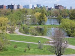
Major parks
- Andrew Haydon ParkAndrew Haydon ParkAndrew Haydon Park is a park on the Ottawa River in the city of Ottawa. It is situated on Carling Avenue at Holly Acres Road.There is a bandshell for outdoor concerts and a picnic area. The Nepean Sailing Club is located nearby at Dick Bell Park...
- Brewer ParkBrewer ParkBrewer Park is a municipal park in Ottawa, Ontario, Canada. It is located on the Rideau River at Bronson Avenue and Carleton University.The park is very popular, attracting many different types of people. In the winter, Brewer park houses a world-class speed skating oval, two smaller-sized hockey...
- Britannia Park
- Confederation ParkConfederation ParkConfederation Park is a park in downtown Ottawa and a National Historic Site of Canada. It is bordered on the south by Laurier Avenue and Ottawa City Hall; on the east by the Rideau Canal; on the north by the Mackenzie King Bridge, the Rideau Centre and the National Arts Centre; and, to the west,...
- Dow's LakeDow's LakeDow's Lake in Ottawa, Canada is a small man-made lake on the Rideau Canal, situated two kilometres north of Hog's Back Falls in the middle of Ottawa. It is at the south end of Preston Street, just south of Carling Avenue, and just to the west of Bronson Avenue...
- Lansdowne ParkLansdowne ParkLansdowne Park is a historic sports, exhibition and entertainment facility in Ottawa, Ontario, Canada, owned by the City of Ottawa. It is located along Bank Street and is adjacent to the Rideau Canal, in central Ottawa...
- Macdonald Gardens
- Major's Hill ParkMajor's Hill ParkMajor's Hill Park is one of the most notable parks in downtown Ottawa. The park stands above the Rideau Canal at the point where it enters the Ottawa River. Across the canal to the west are the parliament buildings, to the north of the park is the National Gallery of Canada, and to the east are...
- Mooney's Bay ParkMooney's Bay ParkMooney's Bay Park is a public park in Ottawa, Canada on the Rideau River. Its main entrance is on Riverside Drive, opposite Ridgewood Avenue, but can also be accessed from Hog's Back Road. It has a beach, picnic areas, a childrens playground and is the site of the Terry Fox Stadium...
- Nepean Creek ParkNepean Creek ParkNepean Creek Park is a linear watershed park, in Ottawa, Canada. It is part of the Greenbelt Master plan of the National Capital Commission. It runs East-West along North Colonnade road for more than a kilometer....
- Rockcliffe Park
- Strathcona ParkStrathcona Park (Ottawa)Strathcona Park is a large park in Ottawa, Canada. It lies on the west bank of the Rideau River and marks the eastern edge of the Sandy Hill neighbourhood....
- Vincent Massey ParkVincent Massey ParkVincent Massey Park is an urban park along the Rideau River in the Confederation Heights neigbourhood of Ottawa, Ontario, Canada, accessible via Heron Road. It is extensively used in the summer for family and group picnics....
Alta VistaAlta Vista (Ottawa)Alta Vista is a neighbourhood in Ottawa, Ontario, Canada. Its boundaries can be broadly described as: Smyth Road in the north, St. Laurent Boulevard in the east, Walkley Road and Heron Road in the south, and Bank Street and Riverside Drive in the west...
- Alta Vista Park
- Applewood Park
- Billings Park
- Canterbury Park
- Cunningham Park
- Edge Hill Park
- Featherston Park
- Hawthorne Park
- Kilborn Park
- Lynda Lane Park
- Orlando Park
- Playfair Park
- Reeves Park
- Robert Andrew Russell Park
- Sharel Park
- Weston Park
Barrhaven
- Barrhaven Park
- Chapman Mills Park
- Escarpment Park
- Flanders Park
- Grovehurst Park
- Houlihan Park
- Maralisa Park
- Moloughney Park
- Mowat Farm Park
- Mulligan Park
- Neill-Nesbitt Park
- Redpath Park
- South Nepean Park
- Stinson Park
- Stonecrest Park
- Strandherd Park
- Totteridge Park
- Utman Park
Beacon Hill South
- Acres Park
- Appleford Park
- Elmridge Park
- Fairfield Park
- Jasmine Park
- Kinsmen Park
- Lockwood Park
- Ogilvie South Park
- Ridge Park
- Trillium Park
Bells Corners
- Arnold Park
- Entrance Park
- George Wilson Park
- Lynwood Park
- Priam Way Park
- Quinpool Park
- Trevor Park
- Westcliffe Park
- Williams Park
Blossom ParkBlossom Park, OntarioBlossom Park is a suburban community located in the south-end of the city of Ottawa, Ontario. It is considered an outer-suburb of the city. Before the 2001 city of Ottawa amalgamation it was a suburb of the city of Gloucester.Population : 12,361....
- Aladdin Park
- Athans Park
- Baden Park
- East Bridle Path Park
- Emerald Woods Park
- North Sawmill Creek Park
- Pine Grove Park
- Russell Boyd Park
- Sawmill Creek Park
- Sieveright Park
- Trappers Park
- West Bridle Path Park
CentretownCentretownCentretown is a neighbourhood in Ottawa, Canada defined by the city as "the area bounded on the north by Gloucester Street and Lisgar Street, on the east by the Rideau Canal, on the south by the Queensway Freeway and on the west by Bronson Avenue." Traditionally it was all of Ottawa west of the...
- Dundonald ParkDundonald ParkDundonald Park is in Centretown, Ottawa, Ontario. It occupies a city block, with Somerset Street West to the north, Bay Street to the west, MacLaren Street to the south, and Lyon Street to the east...
- Jack Purcell Park
- McNabb Park
- Minto ParkMinto ParkMinto Park is a park in downtown Ottawa, Canada. It occupies a full city block, meeting Elgin Street on its west side, Gilmour Street on the north, Cartier Street on the east, and Lewis Street on the south...
- Saint Luke's Park
Civic HospitalCivic HospitalCivic Hospital is a neighbourhood in Ottawa, Canada. It is named after the Ottawa Civic Hospital, which is located in the neighbourhood.Civic Hospital is bounded on the west by Island Park Drive, on the north by Queensway, on the east by the O-Train and on the south by Carling Avenue.The...
- Ev Tremblay Park
- Fairmont Park
- Reid Park
The GlebeThe GlebeThe Glebe is a neighbourhood in Ottawa, Ontario, Canada. It is located just south of Ottawa's downtown area, with its northern border being demarcated by the Queensway highway. It is bounded by the Rideau Canal to the south and east. Many maps show the western edge as Bronson Avenue, but some also...
- Brown's Inlet Park
- Capital Park
- Central ParkCentral Park (Ottawa)Central Park is a park in The Glebe neighbourhood in central Ottawa, Canada.The park has two sections, Central Park East and West divided by Bank Street. To the southeast of the park is the landscaped area around Patterson Creek creating a continued stretch of greenery all the way to the Rideau...
- Commissioner's ParkCommissioner's ParkCommissioner's Park in Ottawa, is a major tulip viewing site with the highest concentration of tulips in the region during the annual Tulip Festival, numbering as many as 300,000....
- Glebe Memorial Park
- Lansdowne ParkLansdowne ParkLansdowne Park is a historic sports, exhibition and entertainment facility in Ottawa, Ontario, Canada, owned by the City of Ottawa. It is located along Bank Street and is adjacent to the Rideau Canal, in central Ottawa...
- Sylvia Holden Park
KitchisippiKitchissippi WardKitchissippi Ward is a city ward in the city of Ottawa, Canada. It gets its name from the Algonquin word for Great River. The ward is slightly west of downtown, and covers the neighbourhoods of Broadview, Champlain Park, Civic Hospital, Hampton Park, Highland Park, Hintonburg, Island Park,...
- Byron Strip
- Champlain Park
- Clare Park
- Fisher Park
- Hampton Park
- Iona Park
- McKellar Park
Lower TownLower TownLowertown is a district in the central area of Ottawa, Ontario, Canada to the east of downtown. It is bounded roughly by Rideau Street to the south, Sussex Drive and Ottawa River to the north, the Rideau Canal to the west, and the Rideau River to the east...
- Besserer Park
- Bingham Park
- Bordeleau Park
- Cathcart Park
- Jules Morin Park
- MacDonald Gardens Park
- Majors Hill Park
ManotickManotick, OntarioManotick, Ontario is an exurb in Eastern Ontario on the Rideau River, located on the south edge of Ottawa's urban area. Manotick is located immediately south of the booming suburbs Barrhaven and Riverside South and is about from downtown Ottawa. It has been part of the City of Ottawa since...
- A.Y. Jackson Park
- Centennial Park
- Chris Bracken Park
- David Bartlett Park
- George McLean Park
- Hilltop Park
- Long Island Road Park
- Long Island Aquatic Club South River Drive Park
- Scharf Park
- Van Vliet Park
- West River Drive Park
- Whitewood Avenue Park
MetcalfeMetcalfe, OntarioMetcalfe is a large village in the Osgoode Ward of the city of Ottawa, Ontario, Canada. The local agricultural fair, the Metcalfe Fair, has been held each fall since 1856....
- Eldon Craig Park
- Joe Rowan Park
- Mckendry Park
- Van Rens Park
Old Ottawa SouthOld Ottawa SouthOld Ottawa South is an older urban neighbourhood in Ottawa, Canada. As of the Canada 2006 Census, 8,168 people lived in Old Ottawa South, a relatively small and compact neighbourhood, located between the Rideau Canal and the Rideau River . The eastern boundary is defined by Riverdale Avenue and...
- Anniversary Park
- Brewer ParkBrewer ParkBrewer Park is a municipal park in Ottawa, Ontario, Canada. It is located on the Rideau River at Bronson Avenue and Carleton University.The park is very popular, attracting many different types of people. In the winter, Brewer park houses a world-class speed skating oval, two smaller-sized hockey...
- Windsor Park
Queenswood South
- Cardinal Farms Park
- Centennial Park
- Kinsella Park
- Mayfair Park
- Yves Richer Park
RiverviewRiverview (Ottawa)Riverview also known as Riverview Park is a neighbourhood in Ottawa, Ontario, Canada. It is southeast of the downtown adjacent to the Rideau River, its location on which is its namesake...
- Alda Burt Park
- Balena Park
- Coronation Park
- Dale Park
- Hutton Park
- Rideau Veteran's Home Memorial Park
- Riverview Park
Riverside ParkRiverside Park, OttawaRiverside Park is a neighbourhood in the south end of Ottawa, Canada.It is bounded on the north by Brookfield Road, on the east by the Airport Parkway, on the south by Walkley Road and on the west by the Rideau River....
- Ernie Calcutt Park
- Marble Park
- Linton Park
- Mooney's Bay ParkMooney's Bay ParkMooney's Bay Park is a public park in Ottawa, Canada on the Rideau River. Its main entrance is on Riverside Drive, opposite Ridgewood Avenue, but can also be accessed from Hog's Back Road. It has a beach, picnic areas, a childrens playground and is the site of the Terry Fox Stadium...
- Paget Park
- Pauline Vanier Park
- Stanstead Park
Sandy HillSandy HillSandy Hill is a bilingual neighbourhood in Ottawa, Ontario located just east of downtown. The neighbourhood is bordered on the west by the Rideau Canal and on the east by the Rideau River. To the north it stretches to Rideau Street and the Byward Market area while to the south it is bordered by...
- Dutchy's Hole ParkDutchy's Hole ParkDutchy's Hole Park is a park on the Rideau River in Ottawa, Ontario, Canada. It is part of the downtown Ottawa neighbourhood of Sandy Hill. The park has a wading pool, playground, and a football field, called Robinson Field...
- Robinson FieldDutchy's Hole ParkDutchy's Hole Park is a park on the Rideau River in Ottawa, Ontario, Canada. It is part of the downtown Ottawa neighbourhood of Sandy Hill. The park has a wading pool, playground, and a football field, called Robinson Field...
- Robinson Field
- Sandy Hill Park
- St Germain Park
- Strathcona ParkStrathcona Park (Ottawa)Strathcona Park is a large park in Ottawa, Canada. It lies on the west bank of the Rideau River and marks the eastern edge of the Sandy Hill neighbourhood....
VanierVanier, Ontario-External links:**...
- Carillon Park
- Emond Park
- Kiwanis Park
- Janeville Park
- Julien Park
- Lawson Park
- Marier Avenue Park
- Nault Park
- Optimiste Park
- Richelieu Park
- River Road Park, Riverain Parc
- St.Laurent Park
Park-like
- The Central Experimental FarmCentral Experimental FarmThe Central Experimental Farm is an agricultural facility, working farm, and research centre of the Research Branch of Agriculture and Agri-Food Canada. As the name indicates, this farm is centrally located in and completely surrounded by the City of Ottawa, Ontario, Canada...
- the centre lawn of Parliament HillParliament HillParliament Hill , colloquially known as The Hill, is an area of Crown land on the southern banks of the Ottawa River in downtown Ottawa, Ontario. Its Gothic revival suite of buildingsthe parliament buildings serves as the home of the Parliament of Canada and contains a number of architectural...
- GreenbeltGreenbelt (Ottawa)The Greenbelt is a crescent of land within the present-day boundaries of the city of Ottawa, Ontario, Canada, in which real estate development is strictly controlled. It begins at Shirleys Bay in the west and extends to Green's Creek in the east...
- Capital PathwayCapital PathwayThe Capital Pathway, also known informally as the The Bike Path, is a recreational pathway interlinking many parks, waterways and sites in Ottawa, Ontario and Gatineau, Quebec...
See also
- List of attractions in Ottawa
- List of National Historic Sites of Canada in Ottawa
- List of designated heritage properties in Ottawa