

List of Montana state parks
Encyclopedia
State park
State parks are parks or other protected areas managed at the federated state level within those nations which use "state" as a political subdivision. State parks are typically established by a state to preserve a location on account of its natural beauty, historic interest, or recreational...
s and reserves in the Montana
Montana
Montana is a state in the Western United States. The western third of Montana contains numerous mountain ranges. Smaller, "island ranges" are found in the central third of the state, for a total of 77 named ranges of the Rocky Mountains. This geographical fact is reflected in the state's name,...
state park system, in the United States.
Current parks
| Park Name | County or Counties | Area in acres (ha) | Date founded |
Stream(s) and / or Lake(s) | Remarks |
|---|---|---|---|---|---|
| Ackley Lake State Park | Judith Basin Judith Basin County, Montana -Demographics:As of the census of 2000, there were 2,329 people, 951 households, and 661 families residing in the county. The population density was -Demographics:... |
160 acres (64.75 ha) | Ackley Lake | ||
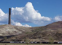
| Anaconda Smelter Stack State Park Anaconda Smelter Stack The Anaconda Smelter Stack is a radial brick smoke stack, once part of the Anaconda Smelter at Anaconda, Montana in the United States. The stack rests on a concrete foundation and measures 585 feet 1.5 inches high. The inside diameter of the stack is at the bottom and at the top... |
Deer Lodge Deer Lodge County, Montana -National protected areas:*Beaverhead National Forest *Deerlodge National Forest -Demographics:As of the census of 2000, there were 9,417 people, 3,995 households, and 2,524 families residing in the county. The population density was 13 people per square mile . There were 4,958 housing units at an... |
12 acres (5.75 ha) | 1986 | The park cannot actually be accessed, but only viewed from a distance. | |
| Bannack State Park | Beaverhead Beaverhead County, Montana -National protected areas:* Beaverhead National Forest * Big Hole National Battlefield* Nez Perce National Historical Park * Red Rock Lakes National Wildlife Refuge-History:... |
1,529 acres (618.75 ha) | 1862 | ||
| Beaverhead Rock State Park | Madison Madison County, Montana -National protected areas:*Beaverhead National Forest *Deerlodge National Forest *Gallatin National Forest -Demographics:As of the census of 2000, there were 6,851 people, 2,956 households, and 1,921 families residing in the county. The population density was 2 people per square mile... |
71 acres (28.75 ha) | 1805 | Beaverhead River | |
| Beavertail Hill State Park Beavertail Hill State Park Beavertail Hill State Park is a Montana State Park located 26 miles east of Missoula, Montana and just off Interstate 90. The park is 65 acres in size and has an elevation of 3,615 feet. Fishing, rafting, and swimming in the Clark Fork River are possible... |
Missoula Missoula County, Montana -National protected areas:*Bitterroot National Forest *Flathead National Forest *Lolo National Forest *Rattlesnake National Recreation Area-Demographics:... |
65 acres (26 ha) | Clark Fork Frontage | ||
| Big Arm State Park | Lake Lake County, Montana -National protected areas:*Flathead National Forest *National Bison Range *Ninepipe National Wildlife Refuge*Pablo National Wildlife Refuge*Swan River National Wildlife Refuge-Demographics:... |
217 acres (87.75 ha) | Flathead Lake | Unit of Flathead Lake State Park | |
| Black Sandy State Park | Lewis and Clark Lewis and Clark County, Montana -National protected areas:* Flathead National Forest * Helena National Forest * Lewis and Clark National Forest * Lolo National Forest * Rocky Mountain Front Conservation Area -Demographics:... |
43 acres (17.75 ha) | Hauser Reservoir | ||
| Brush Lake State Park | Sheridan Sheridan County, Montana -Demographics:As of the census of 2000, there were 4,105 people, 1,741 households, and 1,140 families residing in the county. The population density was 2.4 people per square mile . There were 2,167 housing units at an average density of 1.3 per square mile... |
450 acres (182 ha) | Brush Lake | There are no fish in this lake due to the mineral makeup of the water. | |
| Chief Plenty Coups State Park | Big Horn Big Horn County, Montana - National protected areas :* Bighorn Canyon National Recreation Area * Little Bighorn Battlefield National Monument- Economy :Coal Mining and Agriculture both play major roles in Big Horn County’s economy... |
195 acres (79 ha) | 1928 | ||
| Clark's Lookout State Park | Beaverhead Beaverhead County, Montana -National protected areas:* Beaverhead National Forest * Big Hole National Battlefield* Nez Perce National Historical Park * Red Rock Lakes National Wildlife Refuge-History:... |
7 acres (3 ha) | 1985 | Beaverhead River | |
| Cooney State Park | Carbon Carbon County, Montana -National protected areas:* Bighorn Canyon National Recreation Area * Custer National Forest * Gallatin National Forest -Economy:During the early history of Carbon County, coal mining was the predominant industry... |
309 acres (125 ha) | Cooney Reservoir | ||
| Council Grove State Park | Missoula Missoula County, Montana -National protected areas:*Bitterroot National Forest *Flathead National Forest *Lolo National Forest *Rattlesnake National Recreation Area-Demographics:... |
187 acres (75.75 ha) | |||
| Elkhorn State Park | Jefferson Jefferson County, Montana -National protected areas:*Deerlodge National Forest *Helena National Forest -Demographics:As of the census of 2000, there were 10,049 people, 3,747 households, and 2,847 families residing in the county. The population density was 6 people per square mile . There were 4,199 housing units at an... |
1 acre (.4 ha) | |||
| Finley Point State Park | Lake Lake County, Montana -National protected areas:*Flathead National Forest *National Bison Range *Ninepipe National Wildlife Refuge*Pablo National Wildlife Refuge*Swan River National Wildlife Refuge-Demographics:... |
28 acres (11.25 ha) | Flathead Lake | Unit of Flathead Lake State Park | |
| First Peoples Buffalo Jump State Park First Peoples Buffalo Jump State Park First Peoples Buffalo Jump State Park is a Montana state park in Cascade County, Montana in the United States. The park is and sits at an elevation of .It is located about northwest of the small town of Ulm, which is near the city of Great Falls... |
Cascade Cascade County, Montana -National protected areas:*Benton Lake National Wildlife Refuge*Lewis and Clark National Forest -Economy:Malmstrom Air Force Base is a driving force in the regional economy... |
1,481 acres (599.25 ha) | |||
| Fort Owen State Park | Ravalli Ravalli County, Montana -National protected areas:*Bitterroot National Forest *Lee Metcalf National Wildlife Refuge*Lolo National Forest -Demographics:As of the census of 2000 , there were 36,070 people, 14,289 households, and 10,188 families residing in the county. The population density was 15 people per square mile... |
2 acres (.8 ha) | |||
| Frenchtown Pond State Park | Missoula Missoula County, Montana -National protected areas:*Bitterroot National Forest *Flathead National Forest *Lolo National Forest *Rattlesnake National Recreation Area-Demographics:... |
41 acres (16.5 ha) | Frenchtown Pond | ||
| Giant Springs State Park | Cascade Cascade County, Montana -National protected areas:*Benton Lake National Wildlife Refuge*Lewis and Clark National Forest -Economy:Malmstrom Air Force Base is a driving force in the regional economy... |
675 acres (273.25 ha) | |||
| Granite Ghost Town State Park | Granite Granite County, Montana -National protected areas:*Deerlodge National Forest *Lolo National Forest -Demographics:As of the census of 2000, there were 2,830 people, 1,200 households, and 784 families residing in the county. The population density was 2 people per square mile . There were 2,074 housing units at an average... |
1 acres (.4 ha) | |||
| Greycliff Prairie Dog Town State Park | Sweet Grass Sweet Grass County, Montana -National protected areas:*Custer National Forest *Gallatin National Forest *Lewis and Clark National Forest -Demographics:As of the census of 2000, there were 3,609 people, 1,476 households, and 987 families residing in the county. The population density was 2 people per square mile... |
98 acres (39.65 ha) | |||
| Hell Creek State Park | Garfield Garfield County, Montana -Politics:Garfield County is a solidly Republican county. It might be the most Republican county in Montana and one of the most Republican in the nation.... |
337 acres (136.35 ha) | Fort Peck Lake, Missouri Breaks | ||
| Lake Elmo State Park Lake Elmo State Park Lake Elmo State Park is a Montana state park located in Billings. The park occupies 183 acres and is at an elevation of 3199 feet.The day-use park features swimming, sailing and a dog park.... |
Yellowstone Yellowstone County, Montana -National protected areas:* Nez Perce National Historical Park * Pompeys Pillar National Monument-Demographics:As of the census of 2000, there were 129,352 people, 52,084 households, and 34,219 families residing in the county. The population density was 49 people per square mile . There were... |
183 acres (74 ha) | |||
| Lake Mary Ronan State Park | Lake Lake County, Montana -National protected areas:*Flathead National Forest *National Bison Range *Ninepipe National Wildlife Refuge*Pablo National Wildlife Refuge*Swan River National Wildlife Refuge-Demographics:... |
120 acres (48.5 ha) | Flathead Lake | ||
| Les Mason State Park | Flathead Flathead County, Montana -National protected areas:* Pacific Northwest National Scenic Trail * Flathead National Forest * Glacier National Park * Kootenai National Forest * Lolo National Forest * Lost Trail National Wildlife Refuge-Demographics:... |
8 acres (3.25 ha) | |||
| Lewis and Clark Caverns State Park | Jefferson Jefferson County, Montana -National protected areas:*Deerlodge National Forest *Helena National Forest -Demographics:As of the census of 2000, there were 10,049 people, 3,747 households, and 2,847 families residing in the county. The population density was 6 people per square mile . There were 4,199 housing units at an... |
2,920 acres (1181.75 ha) | |||
| Logan State Park | Lincoln Lincoln County, Montana -National protected areas:* Pacific Northwest National Scenic Trail *Flathead National Forest *Kaniksu National Forest *Kootenai National Forest -Demographics:... |
18 acres (7.25 ha) | Middle Thompson Lake | ||
| Lone Pine State Park | Flathead Flathead County, Montana -National protected areas:* Pacific Northwest National Scenic Trail * Flathead National Forest * Glacier National Park * Kootenai National Forest * Lolo National Forest * Lost Trail National Wildlife Refuge-Demographics:... |
251 acres (101.5 ha) | |||
| Lost Creek State Park Lost Creek State Park Lost Creek State Park, located near Anaconda, Montana, is a state park in size and features towering limestone cliffs and multi-colored rock formations rising above the canyon floor. The park is located at an elevation of and features a short walking trail to Lost Creek Falls, which plunge .... |
Deer Lodge Deer Lodge County, Montana -National protected areas:*Beaverhead National Forest *Deerlodge National Forest -Demographics:As of the census of 2000, there were 9,417 people, 3,995 households, and 2,524 families residing in the county. The population density was 13 people per square mile . There were 4,958 housing units at an... |
502 acres (203 ha) | Lost Creek Falls | ||
| Madison Buffalo Jump State Park Madison Buffalo Jump State Park Madison Buffalo Jump State Park is a Montana state park in Gallatin County, Montana in the United States. The park is and sits at an elevation of . The park is named for a canyon cliff used by Native Americans as a buffalo jump, where herds of bison were stampeded over the cliff as an efficient... |
Gallatin Gallatin County, Montana -National protected areas:* Gallatin National Forest * Yellowstone National Park -Demographics:As of the census of 2000, there were 67,831 people, 26,323 households, and 16,188 families residing in the county. The population density was 26 people per square mile . There were 29,489 housing units... |
638 acres (258.2 ha) | |||
| Makoshika State Park Makoshika State Park Makoshika State Park is the largest of Montana's state parks at more than 11,000 acres . It is located east of Glendive. The park contains spectacular badlands which conceal dinosaur fossils. The park contains rock from the Hell Creek Formation and dinosaurs such as Triceratops are found there... |
Dawson Dawson County, Montana -Economy:Dawson County is known for its dryland grain, coal mines and gas and oil wells. There are 522 current farms and ranches, and 296 commercial businesses.-Demographics:... |
11,634 acres (4708.1 ha) | |||
| Marias River State Park | Toole Toole County, Montana -Demographics:As of the census of 2000, there were 5,267 people, 1,962 households, and 1,308 families residing in the county. The population density was 3 people per square mile . There were 2,300 housing units at an average density of 1 per square mile... |
2,011 acres (813.8 ha) | |||
| Medicine Rocks State Park Medicine Rocks State Park Medicine Rocks State Park is a park owned by the state of Montana in the United States. It is located about west-southwest of Baker, Montana, and north of Ekalaka, Montana. The park is named for the "Medicine Rocks," a series of sandstone pillars similar to hoodoos some high with eerie... |
Carter Carter County, Montana -Demographics:As of the census of 2000, there were 1,360 people, 543 households, and 382 families residing in the county. The population density was -Demographics:... |
330 acres (134.5 ha) | |||
| Missouri Headwaters State Park Missouri Headwaters State Park Missouri Headwaters State Park is a Montana state park that marks the official start of the Missouri River. It includes the Three Forks of the Missouri National Historic Landmark.It is located near Three Forks, Montana at an elevation of .... |
Gallatin Gallatin County, Montana -National protected areas:* Gallatin National Forest * Yellowstone National Park -Demographics:As of the census of 2000, there were 67,831 people, 26,323 households, and 16,188 families residing in the county. The population density was 26 people per square mile . There were 29,489 housing units... |
532 acres (215.3 ha) | Jefferson River, Madison River, Gallatin River | ||
| North Shore State Park | Flathead Flathead County, Montana -National protected areas:* Pacific Northwest National Scenic Trail * Flathead National Forest * Glacier National Park * Kootenai National Forest * Lolo National Forest * Lost Trail National Wildlife Refuge-Demographics:... |
160 acres (64.75 ha) | |||
| Painted Rocks State Park | Ravalli Ravalli County, Montana -National protected areas:*Bitterroot National Forest *Lee Metcalf National Wildlife Refuge*Lolo National Forest -Demographics:As of the census of 2000 , there were 36,070 people, 14,289 households, and 10,188 families residing in the county. The population density was 15 people per square mile... |
23 acres (9.3 ha) | Painted Rocks Reservoir, Bitterroot River | ||
| Parker Homestead State Park Parker Homestead State Park Parker Homestead State Park is a former Montana state park located in southeastern Jefferson County, near Three Forks, Montana in the United States. It is eight miles west of Three Forks on Montana Highway 2. The park is just in size and serves to preserve a sod-roofed log cabin that was built in... |
Jefferson Jefferson County, Montana -National protected areas:*Deerlodge National Forest *Helena National Forest -Demographics:As of the census of 2000, there were 10,049 people, 3,747 households, and 2,847 families residing in the county. The population density was 6 people per square mile . There were 4,199 housing units at an... |
||||
| Pictograph Cave State Park | Yellowstone Yellowstone County, Montana -National protected areas:* Nez Perce National Historical Park * Pompeys Pillar National Monument-Demographics:As of the census of 2000, there were 129,352 people, 52,084 households, and 34,219 families residing in the county. The population density was 49 people per square mile . There were... |
93 acres (37.6 ha) | |||
| Pirogue Island State Park | Custer Custer County, Montana -Economy:The main source of income for Custer County has largely come from cattle ranching and dryland farming. Miles City serves as the center of commerce in an area extending for 100 miles in every direction... |
210 acres (85 ha) | Yellowstone River | ||
| Placid Lake State Park | Powell Powell County, Montana -National protected areas:* Beaverhead-Deerlodge National Forest * Flathead National Forest * Grant-Kohrs Ranch National Historic Site* Helena National Forest * Lolo National Forest * Bob Marshall Wilderness Area... |
31 acres (12.5 ha) | Placid Lake, Clearwater River, Seeley Lake | ||
| Rosebud Battlefield State Park Rosebud Battlefield State Park Rosebud Battlefield State Park, or Rosebud Battlefield-Where the Girl Saved Her Brother is the site of the Battle of the Rosebud. The battle, known also as Crook's Fight on the Rosebud or Battle of Rosebud Creek was fought on June 17, 1876.... |
Big Horn Big Horn County, Montana - National protected areas :* Bighorn Canyon National Recreation Area * Little Bighorn Battlefield National Monument- Economy :Coal Mining and Agriculture both play major roles in Big Horn County’s economy... |
3,052 acres (1235.1 ha) | |||
| Salmon Lake State Park | Missoula Missoula County, Montana -National protected areas:*Bitterroot National Forest *Flathead National Forest *Lolo National Forest *Rattlesnake National Recreation Area-Demographics:... |
42 acres (17 ha) | Salmon Lake, Clearwater River | ||
| Sluice Boxes State Park Sluice Boxes State Park Sluice Boxes State Park is in the Little Belt Mountains of Montana, United States, on the Kings Hill Scenic Byway.Sluice Boxes State Park was established in 1970 and consists of the northern most 8 miles of the Belt Creek canyon in the Little Belt Mountains... |
Cascade Cascade County, Montana -National protected areas:*Benton Lake National Wildlife Refuge*Lewis and Clark National Forest -Economy:Malmstrom Air Force Base is a driving force in the regional economy... |
1,451 acres (587.2 ha) | |||
| Smith River State Park | Meagher Meagher County, Montana -National protected areas:*Gallatin National Forest *Helena National Forest *Lewis and Clark National Forest -Demographics:As of the census of 2000, there were 1,932 people, 803 households, and 529 families residing in the county... |
1 acres (.4 ha) | Smith River | 59-mile segment of the river with only one public put-in and one public take-out for the entire stretch. | |
| Spring Meadow Lake State Park Spring Meadow Lake State Park Spring Meadow Lake State Park is a state park just west of Helena, Montana used primarily as a swimming spot for children, as well as hiking and fishing. During the winter the lake is a popular destination for ice fishing. Bass and trout are the main catches in the small lake.-External links:*... |
Lewis and Clark Lewis and Clark County, Montana -National protected areas:* Flathead National Forest * Helena National Forest * Lewis and Clark National Forest * Lolo National Forest * Rocky Mountain Front Conservation Area -Demographics:... |
61 acres (24.7 ha) | Spring Meadow Lake | ||
| Thompson Falls State Park Thompson Falls State Park Thompson Falls State Park is a Montana state park located near Thompson Falls, Montana. Located on the banks of the Clark Fork River in western Montana, the park is in size, and includes a campground, two boat launches, a kids' fishing pond, and riverside trail... |
Sanders Sanders County, Montana Sanders County is a county located in the U.S. state of Montana. As of 2010, the population was 11,413. Its county seat is Thompson Falls.-Geography:According to the U.S... |
36 acres (14.6 ha) | Clark Fork River, Noxon Rapids Reservoir | ||
| Tongue River Reservoir State Park Tongue River Reservoir State Park The Tongue River Reservoir State Park is a Montana state park. The 12 mile long reservoir is located 6 miles north of Decker, Montana. It is fed from Tongue River. The park occupies 642 acres at an elevation of 3468 feet.... |
Big Horn Big Horn County, Montana - National protected areas :* Bighorn Canyon National Recreation Area * Little Bighorn Battlefield National Monument- Economy :Coal Mining and Agriculture both play major roles in Big Horn County’s economy... |
642 acres (259.8 ha) | Tongue River Reservoir | ||
| Tower Rock State Park | Cascade Cascade County, Montana -National protected areas:*Benton Lake National Wildlife Refuge*Lewis and Clark National Forest -Economy:Malmstrom Air Force Base is a driving force in the regional economy... |
140 acres (56.7 ha) | |||
| Travelers' Rest State Park | Missoula Missoula County, Montana -National protected areas:*Bitterroot National Forest *Flathead National Forest *Lolo National Forest *Rattlesnake National Recreation Area-Demographics:... |
41 acres (16.6 ha) | Lolo Creek | ||
| Ulm Pishkun State Park | Cascade Cascade County, Montana -National protected areas:*Benton Lake National Wildlife Refuge*Lewis and Clark National Forest -Economy:Malmstrom Air Force Base is a driving force in the regional economy... |
||||
| Wayfarers State Park | Lake Lake County, Montana -National protected areas:*Flathead National Forest *National Bison Range *Ninepipe National Wildlife Refuge*Pablo National Wildlife Refuge*Swan River National Wildlife Refuge-Demographics:... |
67 acres (27.1 ha) | Flathead Lake | Unit of Flathead Lake State Park | |
| West Shore State Park | Lake Lake County, Montana -National protected areas:*Flathead National Forest *National Bison Range *Ninepipe National Wildlife Refuge*Pablo National Wildlife Refuge*Swan River National Wildlife Refuge-Demographics:... |
129 acres (52.2 ha) | Flathead Lake | Unit of Flathead Lake State Park | |
| Whitefish Lake State Park Whitefish Lake State Park Whitefish Lake State Park is a Montana state park located two miles west of the town of Whitefish, Montana off U.S. Highway 93. The park is a convenient place to camp for those wanting to stay close to the amenities of Whitefish, although it can be very crowded in summer... |
Flathead Flathead County, Montana -National protected areas:* Pacific Northwest National Scenic Trail * Flathead National Forest * Glacier National Park * Kootenai National Forest * Lolo National Forest * Lost Trail National Wildlife Refuge-Demographics:... |
10 acres (4 ha) | Whitefish Lake | ||
| Wild Horse Island State Park | Lake Lake County, Montana -National protected areas:*Flathead National Forest *National Bison Range *Ninepipe National Wildlife Refuge*Pablo National Wildlife Refuge*Swan River National Wildlife Refuge-Demographics:... |
2,164 acres (875.7 ha) | Flathead Lake | Unit of Flathead Lake State Park | |
| Yellow Bay State Park | Lake Lake County, Montana -National protected areas:*Flathead National Forest *National Bison Range *Ninepipe National Wildlife Refuge*Pablo National Wildlife Refuge*Swan River National Wildlife Refuge-Demographics:... |
15 acres (6 ha) | Flathead Lake, Yellow Bay Creek | Unit of Flathead Lake State Park | |
See also
- List of U.S. national parks