
List of Marilyns in Northern Ireland
Encyclopedia
This is a list of the 66 Marilyns
in Northern Ireland
.
Marilyn (hill)
A Marilyn is a mountain or hill in the United Kingdom, Republic of Ireland or Isle of Man with a relative height of at least 150 metres , regardless of absolute height or other merit...
in Northern Ireland
Northern Ireland
Northern Ireland is one of the four countries of the United Kingdom. Situated in the north-east of the island of Ireland, it shares a border with the Republic of Ireland to the south and west...
.
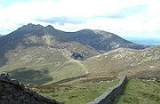
- Slieve DonardSlieve DonardSlieve Donard is a 850 m mountain in County Down, Northern Ireland. It is part of the Mourne Mountains and the highest peak in Northern Ireland and in the wider province of Ulster. It is the 19th highest peak on the island of Ireland...
- 850 m
- Slieve CommedaghSlieve CommedaghSlieve Commedagh is a 767 m mountain in County Down, Northern Ireland. It is the second-highest of the Mourne Mountains, after Slieve Donard, and the second-highest mountain in Northern Ireland....
- 767 m - Slieve BinnianSlieve BinnianSlieve Binnian is the third highest mountain in Northern Ireland at . The name comes from the rocky tors situated around the top of the mountain. These very rugged crest of rocky tors makes it easy to identify in views around the Mourne Mountains....
- 747 m - Slieve BearnaghSlieve BearnaghSlieve Bearnagh is a mountain in the Mourne Mountains, Northern Ireland. Its summit is crowned by a number of rocky tors. The Mourne Wall crosses the summit of Slieve Bearnagh east to west. Paths lead to the cols on either side of the mountain, namely Pollaphuca to the west and Hare's Gap to the...
- 739 m - Slieve Meelbeg - 708 m
- Slievelamagan - 704 m
- Sawel MountainSawel MountainSawel Mountain, historically Slieve Sawel , is a mountain in County Londonderry and County Tyrone, Northern Ireland. It is the highest peak in the Sperrin Mountains, and the seventh highest in Northern Ireland. To the north of Sawel is County Londonderry, and to the south, County Tyrone. The summit...
- 678 m - Slieve MuckSlieve MuckSlieve Muck is one of the Mourne Mountains in County Down, Northern Ireland. It has a height of 674 metres . Its summit overlooks Spelga Dam and the Deer's Meadow, the source of the River Bann....
- 673 m - CuilcaghCuilcaghCuilcagh, historically Slieve Cuilcagh , is the highest mountain in the Breifne area and the 165th highest on the island of Ireland . The summit lies on the border between County Fermanagh and County Cavan , and is the highest point in both counties...
- 665 m - Eagle Mountain - 638 m
- Mullaghclogha - 635 m
- Mullaghaneany - 627 m
- Slieve GullionSlieve GullionSlieve Gullion is a mountain in the south of County Armagh in Northern Ireland. The mountain forms the core of the Ring of Gullion and stands as the highest point in the county with an elevation of 573 metres...
- 573 m - Carnanelly - 562 m
- Slievemoughanmore - 559 m
- MullaghmoreMullaghmore (marilyn)Mullaghmore is a mountain in County Londonderry, Northern Ireland. It is part of the Sperrins and the 359th highest mountain in Ireland The summit is dominated by a large telecommunication tower. The mountain is located north of the village of Draperstown....
- 550 m - TrostanTrostanTrostan is a mountain in County Antrim, Northern Ireland and at 551 metres is the highest point in the county. Trostan is the 362nd highest mountain in Ireland.-See Also:*List of Irish counties by highest point...
- 550 m - MullaghcarnMullaghcarnMullaghcarn is a mountain in the southwest Sperrins, County Tyrone, Northern Ireland. The peak reaches a height of 542 m , and is the 370th highest in Ireland. Mullaghcarn is in Omagh District Council, on the edge of Gortin Glen Forest Park, and is the most southerly peak in the Sperrins...
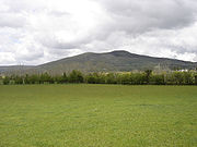
- 542 m - Slieve CroobSlieve CroobSlieve Croob is the tallest of a group of peaks in the middle of County Down, Northern Ireland. These peaks lie north of the Mourne Mountains, between the village of Dromara and the town of Castlewellan. Slieve Croob has been designated an Area of Outstanding Natural Beauty...
- 534 m - Slieve GallionSlieve GallionSlieve Gallion is a mountain in County Londonderry, Northern Ireland. By road, it is from Moneymore, from Cookstown, and from Magherafelt. It is the eastern limit of the Sperrin Mountains range...
- 528 m - Knocklayd - 514 m
- Slieveanorra - 508 m
- Slievemartin - 485 m
- Mullaghash - 480 m
- DivisDivisDivis is a large mountain and area of sprawling moorland to the north-west of Belfast in County Antrim, Northern Ireland. The mountain is 478 m tall, making it the highest of the Belfast Hills...
- 478 m - Agnew's Hill - 474 m
- BenbradaghBenbradaghBenbradagh is a mountain in County Londonderry, Northern Ireland. It is the second most northerly summit in the Sperrin Mountains area and the 564th highest summit in Ireland. Its summit rises to . The mountain is located to the east of Dungiven....
- 465 m - Slievenaglogh - 445 m
- Mid Hill - 444 m
- SlemishSlemishSlemish, historically called Slieve Mish , is a volcanic plug in County Antrim, Northern Ireland. It lies a few miles east of Ballymena, in the townland of Carnstroan.Slemish is the remains of the plug of an extinct volcano...
- 437 m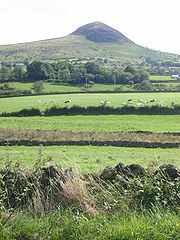
- Camlough Mountain - 423 m
- Bessy Bell - 420 m
- Curraghchosaly Mountain - 416 m
- Owenreagh Hill - 407 m
- Balix Hill - 403 m
- Donald's HillDonald's HillDonald's Hill is a hill in the middle of County Londonderry, Northern Ireland. The summit reaches 399 metres above sea level and classifies as a Marilyn...
- 399 m
- Belmore MountainBelmore MountainBelmore Mountain is a hill in the townland of Gortgall, western County Fermanagh, Northern Ireland. With a summit roughly above sea level, it is the second highest point in Fermanagh, the highest being at Cuilcagh on the Northern Ireland–Republic of Ireland border in the south of the...
- 398 m - LoughermoreLoughermoreLoughermore is a mountain in County Londonderry, Northern Ireland. It is the 847th highest mountain in Ireland and lies in a large uplands area known as the Loughermore Hills, which is bounded to the west and south by the Rivers Faughan and Foreglen and to the east, by the River Roe.-References:...
- 396 m - ReyfadReyfadReyfad is a townland in County Fermanagh, Northern Ireland. It lies in the land division of Old Barr, in the civil parish of BohoThis mountainous townland is well known for its extensive cave system and Neolithic stones.The summit of the nearby hill is known as Tullybrack or Reyfad Mountain but...
- 386 m - BinevenaghBinevenaghBinevenagh or Benevenagh marks the western extent of the Antrim Plateau formed around 60 million years ago by molten lava. The plateau and steep cliffs extend for over 6 miles across the peninsula of Magilligan and dominating the skyline over the villages of Bellarena, Downhill, Castlerock and...
- 385 m - Craignamaddy - 382 m
- Gruggandoo - 382 m
- Oughtmore - 382 m
- Slieve Beagh - 380 m
- Benaughlin MountainBenaughlin MountainBenaughlin Mountain is a mountain in the Cuilcagh Mountain range in County Fermanagh, Northern Ireland. It has a limestone composition and is known as Bin Mountain in the local area.At its highest point, Benaughlin is 373 metres above sea level...
- 373 m - Slievekirk - 370 m
- Carrigatuke - 364 m
- Big Collin - 353 m
- Bolaght Mountain - 345 m
- DooishDooishDooish is a village and townland near Drumquin in County Tyrone, Northern Ireland. In the 2001 Census it had a population of 93 people. It lies within the Omagh District Council area.-References:*...
- 341 m - Crocknamoghil - 335 m
- Crockdooish - 321 m
- Tobernaveen Hill - 319 m
- Brougher Mountain - 316 m
- SlievemoreSlievemoreSlievemore is the second highest peak on Achill Island, in County Mayo, Ireland. Its elevation is 671 metres.-Archaeology:* Achill Archaeological Field School is based at the Achill Archaeology Centre in Dooagh. It was founded in 1991 and is a training school for students of archaeology and...
- 314 m - Carn Hill - 310 m
- Croslieve - 308 m
- Knockchree - 305 m
- Pollnalaght - 298 m
- Tullynasoo Mountain - 280 m
- Tievecrom - 264 m
- Holywell Hill - 260 m
- Forster's Mountain - 242 m
- Knockiveagh - 237 m
- Corrody Hill - 221 m
- Gortmonly Hill - 218 m
- Cairngaver - 214 m
- Cross Slieve - 206 m