
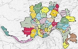
List of Cincinnati neighborhoods
Encyclopedia

List
Prevalent communities that exist inside of neighborhoods are indicated by sub-bullets.- Avondale
- Bond Hill
- California
- Camp WashingtonCamp Washington, CincinnatiCamp Washington is a residential neighborhood located in Cincinnati, Ohio, USA, home to the award-winning Cincinnati chili parlor, Camp Washington Chili...
- CarthageCarthage, CincinnatiCarthage is a residential neighborhood located in the Mill Creek valley in Cincinnati, Ohio. Carthage was incorporated in 1861 and then annexed into Cincinnati in 1911. It shares a border with Elmwood Place, Ohio, which, with adjacent St. Bernard, Ohio, forms a city island in the middle of...
- Clifton
- CUF
- Clifton Heights
- University Heights
- Fairview
- College HillCollege Hill, CincinnatiCollege Hill is a residential neighborhood of Cincinnati, Ohio. Originally a wealthy suburb called Pleasant Hill due to its prime location, it was renamed College Hill because of the two colleges that were established there in the mid-nineteenth century...
- Columbia-TusculumColumbia-Tusculum, CincinnatiColumbia-Tusculum is the oldest neighborhood in Cincinnati, Ohio and is located on the East Side of the city. According to CincinnatiHome.org, as of 1997, the population of Columbia-Tusculum was 2,619. 90.3 percent of the population is white and 42.9 percent are between 25 and 44 years old...
- Corryville
- Covedale
- Downtown CincinnatiDowntown CincinnatiDowntown Cincinnati is the central business district of Cincinnati, Ohio, and one of its 52 neighborhoods.-Geography:Downtown Cincinnati's streets are arranged in a grid configuration. It is bisected by Vine Street....
- The BanksThe BanksThe Banks is the name given to the current mixed-use project being developed on the land between Paul Brown Stadium and Great American Ball Park along the Ohio River in Cincinnati, Ohio.-History:...
- The Banks
- East End
- EastgateEastgateEastgate may refer to a place:in the Americas:* Eastgate, Indianapolis, Indiana, USA* Eastgate, Roanoke, Virginia, USA neighborhood* Eastgate, Washington, USAin Europe:* Eastgate, County Durham, England* Eastgate, Norfolk, England...
- East Price HillPrice Hill, CincinnatiPrice Hill is a neighborhood of Cincinnati, Ohio, located north of Sedamsville and Riverside, south of Westwood and South Fairmount, and west of Queensgate. It is one of the oldest outlying settlements of Cincinnati, and includes parts of the zip codes 45205, 45238, and 45204.-Geography:Price Hill...
- East Walnut HillsEast Walnut Hills, CincinnatiEast Walnut Hills is a neighborhood in Cincinnati, Ohio, United States. Founded in 1867, originally as the independent incorporated village of Woodburn, East Walnut Hills is a diverse neighborhood, both ethnically and economically...
- East Westwood
- English Woods
- EvanstonEvanston, CincinnatiEvanston, Ohio is a neighborhood in the city of Cincinnati, Hamilton County, Ohio, United States. A mostly African American neighborhood since the 1960s, it's known as the birthplace of actress Doris Day, and is bordered by the neighborhoods of East Walnut Hills, Hyde Park, North Avondale, and...
- Fay Apartments
- HartwellHartwell, CincinnatiHartwell is a neighborhood in northern Cincinnati, Ohio, centered roughly on the intersections of I-75 and Ronald Regan Cross County Highway. Its boundaries are a combination of Caldwell Park and R R Cross County Highway to the south, I-75 to the east, and a combination of Millsdale Road and...
- The HeightsUniversity of CincinnatiThe University of Cincinnati is a comprehensive public research university in Cincinnati, Ohio, and a part of the University System of Ohio....
- Hyde Park
- Kennedy HeightsKennedy Heights, CincinnatiKennedy Heights is a residential neighborhood of Cincinnati, Ohio, home to Daniel Drake Park and Shroder Paideia High School. Kennedy Heights shares its border with Pleasant Ridge and Silverton, and the area was one of Cincinnati's first settlements....
- Linwood
- Lower Price HillPrice Hill, CincinnatiPrice Hill is a neighborhood of Cincinnati, Ohio, located north of Sedamsville and Riverside, south of Westwood and South Fairmount, and west of Queensgate. It is one of the oldest outlying settlements of Cincinnati, and includes parts of the zip codes 45205, 45238, and 45204.-Geography:Price Hill...
- Madisonville
- Millvale
- Mount Adams
- Mount Airy
- Mount AuburnMount Auburn Historic DistrictMount Auburn Historic District is located in the Mount Auburn neighborhood in Cincinnati, Ohio. It extends along both sides of Auburn Avenue roughly between Ringold Street and William H. Taft Road....
- Prospect Hill
- Mount Lookout
- Mount Washington
- North Avondale
- North Fairmount
- NorthsideNorthside, CincinnatiNorthside is a neighborhood in Cincinnati, Ohio. It was originally known as Cumminsville, but changed names to "Northside" several decades ago after I-74 divided the neighborhood into Northside and South Cumminsville...
(formerly Cumminsville) - Oakley
- Over-the-RhineOver-the-RhineOver-the-Rhine, sometimes shortened to OTR, is a neighborhood in Cincinnati, Ohio. It is believed to be the largest, most intact urban historic district in the United States. Over-the-Rhine was added to the National Register of Historic Places in 1983 with 943 contributing buildings...
- Paddock Hills
- Pendleton
- Pleasant RidgePleasant Ridge, CincinnatiPleasant Ridge is a mostly gaslight residential neighborhood in Cincinnati, Ohio with a small business district occupied largely by long-standing, independent businesses...
- Queensgate
- Riverside
- Roselawn
- Sayler Park
- Sedamsville
- South Cumminsville
- South Fairmount
- Spring Grove Village (formerly Winton Place)
- Walnut Hills
- West End
- Price HillPrice Hill, CincinnatiPrice Hill is a neighborhood of Cincinnati, Ohio, located north of Sedamsville and Riverside, south of Westwood and South Fairmount, and west of Queensgate. It is one of the oldest outlying settlements of Cincinnati, and includes parts of the zip codes 45205, 45238, and 45204.-Geography:Price Hill...
- Westwood
- Winton Hills
Communities in Greater Cincinnati
These communities do not fall within the city limits of Cincinnati, Ohio. Instead, they are considered part of the Cincinnati – Northern Kentucky metropolitan area and are considered neighborhoods of Greater Cincinnati.Kentucky
- AlexandriaAlexandria, KentuckyAs of the census of 2000, there were 8,286 people, 2,884 households, and 2,275 families residing in the city. The population density was 1,538.7 people per square mile . There were 2,989 housing units at an average density of 555.1 per square mile...
- BellevueBellevue, KentuckyBellevue is a city in Campbell County, Kentucky, United States, along the Ohio River. The population was 5,955 at the 2010 census.-Geography:Bellevue is located in the extreme northern portion of Kentucky, directly across the Ohio River from the Mount Adams neighborhood of Cincinnati, Ohio...
- BromleyBromley, KentuckyBromley is a city in Kenton County, Kentucky, United States, along the Ohio River. The population was 838 at the 2000 census.-Geography:Bromley is located at ....
- BurlingtonBurlington, KentuckyBurlington is a census-designated place in and the county seat of Boone County, Kentucky, United States. The population was 10,779, at the 2000 census.-Geography:...
- Cold SpringCold Spring, KentuckyCold Spring is a city in Campbell County, Kentucky, United States. The population was 3,806 at the 2000 census.-Geography:Cold Spring is located at ....
- CovingtonCovington, Kentucky-Demographics:As of the census of 2000, there were 43,370 people, 18,257 households, and 10,132 families residing in the city. The population density was 3,301.3 people per square mile . There were 20,448 housing units at an average density of 1,556.5 per square mile...
- Crescent SpringsCrescent Springs, KentuckyCrescent Springs is a city in Kenton County, Kentucky, United States. The population was 3,931 at the 2000 census.-Geography:Crescent Springs is located at ....
- Crestview HillsCrestview Hills, KentuckyCrestview Hills is a city in Kenton County, Kentucky, United States. The population was 2,889 at the 2000 census.-Geography:Crestview Hills is located at ....
- DaytonDayton, KentuckyDayton is a city in Campbell County, Kentucky, United States, along a bend of the Ohio River. The population was 5,966 at the 2000 census. It is less than from downtown Cincinnati, Ohio.-Geography:Dayton is located at ....
- EdgewoodEdgewood, KentuckyThere were 3,099 households out of which 44.4% had children under the age of 18 living with them, 78.4% were married couples living together, 6.2% had a female householder with no husband present, and 13.1% were non-families. 11.1% of all households were made up of individuals and 4.5% had someone...
- ElsmereElsmere, KentuckyElsmere is a city in Kenton County, Kentucky, United States. The population was 8,451 at the 2010 census. The city was named after Elsmere Avenue in Norwood, Ohio.-Mayor Bradford:...
- ErlangerErlanger, KentuckyErlanger is a city in Kenton County, Kentucky, United States. The population was 16,676 at the 2000 census.- Geography :Erlanger is located at ....
- Fort MitchellFort Mitchell, KentuckyAs of the census of 2010, there were 8,207 people, 3,530 households, and 2,033 families residing in the city. The population density was 2,581.8 people per square mile . There were 3,744 housing units at an average density of 1,195.0 per square mile...
- Fort ThomasFort Thomas, KentuckyFort Thomas is a city in Campbell County, Kentucky, on the southern bank of the Ohio River and the site of an 1890 US Army post. The population was 16,325 at the 2010 census, making it the largest city in Campbell County and it is officially part of the Cincinnati – Northern Kentucky metropolitan...
- Fort WrightFort Wright, KentuckyFort Wright is a city in Kenton County, Kentucky, United States. The population was 5,723 at the 2010 census.-Geography:Fort Wright is located at ....
- FlorenceFlorence, KentuckyFlorence is a city in Boone County, Kentucky, United States. The population was 29,951 at the 2010 census.-History:The Florence area was originally known as Crossroads, because of the convergence of several roads from Burlington and Union at Ridge Road...
- HebronHebron, KentuckyHebron is an unincorporated community in Boone County, Kentucky, United States. It is the location of Cincinnati/Northern Kentucky International Airport, which serves Cincinnati and the tri-state area.- Growth :...
- Highland HeightsHighland Heights, KentuckyHighland Heights is a city in Campbell County, Kentucky, United States. The population was 6,554 at the 2000 census.Highland Heights is home to Northern Kentucky University...
- IndependenceIndependence, KentuckyIndependence is a suburban city in Kenton County, Kentucky, United States. The population was 14,982 at the 2000 census and estimated to be 22,105 in 2009. It is one of two county seats of Kenton County...
- Lakeside ParkLakeside Park, KentuckyLakeside Park is a city in Kenton County, Kentucky, United States. As of the 2000 census, the city had a total population of 2,869.- Geography :Lakeside Park is located at ....
- LudlowLudlow, KentuckyLudlow is a city in Kenton County, Kentucky, United States. The population was 4,409 at the 2000 census. Ludlow is a suburb of Covington, Kentucky, and Cincinnati, Ohio, located on the Ohio River...
- NewportNewport, KentuckyNewport is a city in Campbell County, Kentucky, United States, at the confluence of the Ohio and Licking rivers. The population was 15,273 at the 2010 census. Historically, it was one of four county seats of Campbell County. Newport is part of the Greater Cincinnati, Ohio Metro Area which...
- Park HillsPark Hills, KentuckyPark Hills is a city in Kenton County, Kentucky, United States. A small Upper-Middle class bedroom community located in the Cincinnati Metro Area. Where most home vaules exceed $200,000 dollars. Desirable for its location, only 3 miles from the Cincinnati's Downtown, and 6 miles to the...
- SouthgateSouthgate, KentuckySouthgate is a city in Campbell County, Kentucky, United States, a part of metropolitan Cincinnati, Ohio. The population was 3,472 at the 2000 census.-History:...
- Taylor MillTaylor Mill, KentuckyIn the city the population was spread out with 26.4% under the age of 18, 9.3% from 18 to 24, 32.3% from 25 to 44, 21.6% from 45 to 64, and 10.4% who were 65 years of age or older. The median age was 36 years. For every 100 females there were 96.0 males...
- UnionUnion, KentuckyUnion is a city in Boone County, Kentucky, United States. The population was 5,379 in the 2010 Census. Previously a small rural community, the city began to experience rapid residential development in the 1990s and 2000s and has now become one of Cincinnati's more affluent suburbs.- History :The...
- Verona
- Villa HillsVilla Hills, KentuckyThe median income for a household in the city was $73,523, and the median income for a family was $79,810. Males had a median income of $60,792 versus $34,949 for females. The per capita income for the city was $34,373...
- WaltonWalton, KentuckyWalton is a city in Boone and Kenton Counties in the U.S. state of Kentucky. The population was 3,635 in the 2010 Census.-Tourism:Nearby Florence offers thoroughbred racing at Turfway Park....
- WilderWilder, KentuckyWilder is a city in Campbell County, Kentucky, United States. The population was 3,035 at the 2010 census.-Geography:Wilder is located at ....
Ohio
- AddystonAddyston, OhioAddyston is a village in Hamilton County, Ohio, United States, along the Ohio River. The population was 1,010 at the 2000 census.-Geography:Addyston is located at ....
- Anderson TownshipAnderson Township, Hamilton County, OhioAnderson Township is one of the twelve townships of Hamilton County, Ohio, United States. Located in the southeastern part of the county and less than 15 minutes from downtown, the township has been named one of the Cincinnati area's most desirable neighborhoods to live...
- Blue AshBlue Ash, OhioBlue Ash is a city in Hamilton County, Ohio, United States, and an inner suburb of Cincinnati, which is located just to the south. The population was 12,513 at the 2000 census.-Geography:Blue Ash is located at ....
- CheviotCheviot, OhioCheviot is a city located in west central Hamilton County, Ohio. The population was 9,015 at the 2000 census.- History :In 1814 a Scottish immigrant named John Craig purchased a half section of of Green Township from Elias Boudinot. He built an inn and tavern on the Harrison Pike. In 1818 Craig...
- ClevesCleves, OhioCleves is a village, founded in 1818, along the Ohio River in western Hamilton County, Ohio, United States. The population was 2,790 at the 2000 census...
- Colerain TownshipColerain Township, Hamilton County, OhioColerain Township is one of the twelve townships of Hamilton County, Ohio, United States. The 2000 census found 60,144 people in the township, more than in any other township in Ohio.-Geography:...
- CovedaleCovedale, OhioCovedale is a former village in Hamilton County, Ohio, United States. The main area of the village was annexed by the city of Cincinnati and is now a neighborhood of about 15,000 people in the western part of the city...
- DelhiDelhi Township, Hamilton County, OhioDelhi Township is one of the twelve townships of Hamilton County, Ohio, United States. The 2000 census found 30,104 people in the township.-Geography:Located in the southwestern part of the county along the Ohio River, it has the following borders:...
- Deer ParkDeer Park, OhioDeer Park is a city in Hamilton County, Ohio, United States. The population was 5,736 at the 2010 census.-Geography:Deer Park is located at ....
- DentDent, OhioDent is a census-designated place in Hamilton County, Ohio, United States. The population was 7,612 at the 2000 census.-Geography:Dent is located at .According to the United States Census Bureau, the CDP has a total area of , all of it land....
- FairfieldFairfield, OhioFairfield is a city in Butler County in the U.S. state of Ohio, near Cincinnati. Fairfield was incorporated in 1955. The population was 42,510 at the 2010 census. The city school district is one of the largest in Ohio, with Fairfield High School graduating 842 students in June 2009. Fairfield is...
- Forest ParkForest Park, OhioAs of the census of 2000, there were 19,463 people, 7,505 households, and 5,238 families residing in the city. The population density was 2,990.4 people per square mile . There were 7,748 housing units at an average density of 1,190.4 per square mile...
- Golf ManorGolf Manor, OhioGolf Manor is a village in Hamilton County, Ohio, United States. It is surrounded nearly completely by the Pleasant Ridge and Roselawn neighborhoods of Cincinnati...
- HarrisonHarrison, OhioHarrison is a city in Hamilton County, Ohio, United States. The city is located in the Cincinnati-Northern Kentucky metropolitan area. The population was 7,487 as of the 2000 census.-History:...
- Indian HillIndian Hill, OhioThe Village of Indian Hill is a city in Hamilton County, Ohio, United States, and an affluent suburb of the Greater Cincinnati area. The population was 5,907 at the 2000 census. Prior to 1970, Indian Hill was incorporated as a village, but under Ohio law became designated as a city once its...
- LebanonLebanon, OhioThe population at the 2010 census was 20,033. As of the census of 2000, there were 16,962 people residing in the city. The population density was 1,440.6 people per square mile . There were 6,218 housing units at an average density of 528.1 per square mile...
- LovelandLoveland, OhioLoveland is a city in Hamilton, Clermont, and Warren counties in the southwestern part of the U.S. state of Ohio. Considered part of the Greater Cincinnati area, Loveland is located near exit 52 off Interstate 275, about northeast of the Cincinnati city limits. It borders Symmes, Miami and...
- MadeiraMadeira, OhioMadeira is a city in Hamilton County, Ohio, United States. The population was 8,923 at the 2000 census. Madeira has a Council-Manager form of government, where the elected City Council appoints a paid City Manager to run the day to day operations of the city. Madeira is served by its own Police...
- MariemontMariemont, OhioMariemont is a planned community village in Hamilton County, Ohio, United States. It includes one or two historic districts, Village of Mariemont and Mariemont Historic District. Founded in the 1920s by Mary Emery, Mariemont exhibits English architecture from Norman to classic Georgian style...
- MasonMason, OhioMason is an affluent city in southwestern Warren County, Ohio, United States, 22 miles away from Cincinnati . As of the 2010 census, Mason's population was 30,712. Mason has experienced fast growth, with its historic Main Street remaining at the center of the community...
- Monfort Heights EastMonfort Heights East, OhioMonfort Heights East is a census-designated place in Hamilton County, Ohio, United States. The population was 3,880 at the 2000 census. The name of the CDP is based on the community of Monfort Heights in Green Township.-Geography:...
- Monfort Heights SouthMonfort Heights South, OhioMonfort Heights South is a census-designated place in Hamilton County, Ohio, United States. The population was 4,466 at the 2000 census. The name of the CDP is based on the community of Monfort Heights in Green Township.-Geography:...
- MontgomeryMontgomery, OhioMontgomery is a city in Hamilton County, Ohio, United States settled in 1796. The town was a coach stop on the Cincinnati-Zanesville Road, later known as the Montgomery Pike with an Inn, two taverns, a grist mill and a carding mill to process its agricultural products...
- North College HillNorth College Hill, OhioNorth College Hill is a city in Hamilton County in the southwestern part of the U.S. state of Ohio approximately ten miles north of downtown Cincinnati. As of the 2010 census, the city population was 9,397...
- NorwoodNorwood, OhioNorwood is the second most populous city in Hamilton County, Ohio, United States. The city is an enclave of the larger city of Cincinnati. The population was 21,675 at the 2000 census. Originally settled as an early suburb of Cincinnati in the wooded countryside north of the city, the area is...
- ReadingReading, OhioReading is a city in Hamilton County, Ohio, United States. The population was 11,292 at the 2000 census. It is a suburb of Cincinnati. Reading is also the Home of 2003 Division 3 State Boys Basketball Champions...
- SharonvilleSharonville, OhioSharonville is a city in Butler and Hamilton counties in the U.S. state of Ohio. The population was 13,804 at the 2000 census.-Geography:Sharonville is located at .It is part of the Cincinnati metropolitan area....
- SilvertonSilverton, OhioSilverton is a city in Hamilton County, Ohio, United States. The city was formed out of Columbia and Sycamore Townships, but withdrew from both and formed a paper township...
- SpringdaleSpringdale, OhioAs of the census of 2000, there were 10,563 people, 4,421 households, and 2,816 families residing in the city. The population density was 2,131.0 people per square mile . There were 4,607 housing units at an average density of 929.4 per square mile...
- St. BernardSt. Bernard, OhioSt. Bernard is a small city in Hamilton County, Ohio, United States. The population was 4,924 at the 2000 census.-Geography:St. Bernard is located at , and along with Norwood and Elmwood Place, is an enclave surrounded by the city of Cincinnati.According to the United States Census Bureau, the...
- Symmes TownshipSymmes Township, Hamilton County, OhioSymmes Township is one of the twelve townships of Hamilton County, Ohio, United States. The 2000 census found 14,771 people in the township.-Geography:...
- West ChesterWest Chester Township, Butler County, OhioWest Chester Township, formerly known as Union Township, is a township located in the southeast corner of Butler County in the southwestern part of the U.S. state of Ohio, one of thirteen townships in the county. It is situated between Sharonville and Monroe, about 18 miles north of Cincinnati, and...
- White OakWhite Oak, OhioWhite Oak is a census-designated place in Hamilton County, Ohio, United States. The population was 13,277 at the 2000 census.-Geography:White Oak is located at ....
- WyomingWyoming, OhioWyoming is a city in Hamilton County, Ohio, United States. The population was 8,261 at the 2000 census.Wyoming has a renowned education program - the Wyoming City School District was ranked first in the State of Ohio on the 2004-2005 State Report Card, with an index score of 108.2...
External links
- Cincinnati Heat Map displays the average real estate price for each neighborhood.