
Linganamakki dam
Encyclopedia
The Linganamakki dam was constructed by the Karnataka State Government
in 1964. Located in the Sagara
taluk, the dam has a length of 2.4 km, stretching across the Sharavathi river
. It is located about 6 km from Jog Falls
.
The dam was designed to impound 4368 million cubic meter of water in an area of around 300 km², submerging 50.62 km² of wetland and 7 km² of dry land, with the remaining being forest land and wasteland.
The dam's height is 1819 feet (554.4 m) above sea level.
It receives water mainly from rainfall and also from the Chakra and Savahaklu reservoirs, which are linked to Linganamakki through a canal. The water from the Linganamakki dam flows to Talakalale Balancing Reservoir through a trapezoidal canal with a discharge capacity of 175.56 m³/s. The length of this channel is about 4318.40 m with a submersion of 7.77 km². It has a catchment area of about 46.60 km².
Behind the dam is a large reservoir. The discharge from the dam can be quite heavy. When the dam's sluice
gates are closed upstream from Jog Falls, it is possible to walk down into the fall's ravine
.
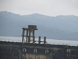
The power house has a power generation capacity of 55 MW, from two generating units. They are driven by vertical axis Kaplan turbine
s. The power house is on the left side of the dam.
Government of Karnataka
The Government of Karnataka is a democratically elected body with the Governor as the constitutional head. The Governor who is appointed for a period of five years appoints the Chief Minister and his council of ministers...
in 1964. Located in the Sagara
Sagara, India
Sâgara is a city located in Shimoga district in the Indian state of Karnataka. Located within the Western Ghats range, it is known for its proximity to Jog Falls and to the historical places of Ikkeri and Keladi. Varadamoola, the origin of the river Varada, is also near Sagara...
taluk, the dam has a length of 2.4 km, stretching across the Sharavathi river
Sharavathi River
Sharavathi is a river which originates and flows entirely within the state of Karnataka in India. It is one of the few westward flowing rivers of India and a major part of the river basin lies in the Western Ghats. The famous Jog Falls are formed by this river...
. It is located about 6 km from Jog Falls
Jog Falls
Jog Falls , created by the Sharavathi River falling from a height of is the second-highest plunge waterfall in India Located in Sagara, Karnataka Shimoga District of Karnataka state, these segmented falls are a major tourist attraction...
.
The dam was designed to impound 4368 million cubic meter of water in an area of around 300 km², submerging 50.62 km² of wetland and 7 km² of dry land, with the remaining being forest land and wasteland.
The dam's height is 1819 feet (554.4 m) above sea level.
It receives water mainly from rainfall and also from the Chakra and Savahaklu reservoirs, which are linked to Linganamakki through a canal. The water from the Linganamakki dam flows to Talakalale Balancing Reservoir through a trapezoidal canal with a discharge capacity of 175.56 m³/s. The length of this channel is about 4318.40 m with a submersion of 7.77 km². It has a catchment area of about 46.60 km².
Behind the dam is a large reservoir. The discharge from the dam can be quite heavy. When the dam's sluice
Sluice
A sluice is a water channel that is controlled at its head by a gate . For example, a millrace is a sluice that channels water toward a water mill...
gates are closed upstream from Jog Falls, it is possible to walk down into the fall's ravine
Ravine
A ravine is a landform narrower than a canyon and is often the product of streamcutting erosion. Ravines are typically classified as larger in scale than gullies, although smaller than valleys. A ravine is generally a fluvial slope landform of relatively steep sides, on the order of twenty to...
.
The power house has a power generation capacity of 55 MW, from two generating units. They are driven by vertical axis Kaplan turbine
Kaplan turbine
The Kaplan turbine is a propeller-type water turbine which has adjustable blades. It was developed in 1913 by the Austrian professor Viktor Kaplan, who combined automatically adjusted propeller blades with automatically adjusted wicket gates to achieve efficiency over a wide range of flow and...
s. The power house is on the left side of the dam.