
Lilydale, Tasmania
Encyclopedia
Tasmania
Tasmania is an Australian island and state. It is south of the continent, separated by Bass Strait. The state includes the island of Tasmania—the 26th largest island in the world—and the surrounding islands. The state has a population of 507,626 , of whom almost half reside in the greater Hobart...
, Australia. The town is 28 kilometres (17 mi) northeast of Launceston
Launceston, Tasmania
Launceston is a city in the north of the state of Tasmania, Australia at the junction of the North Esk and South Esk rivers where they become the Tamar River. Launceston is the second largest city in Tasmania after the state capital Hobart...
and is a part of the Launceston municipality. It is located near Mount Arthur
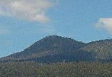
Mount Arthur (Tasmania)
Mount Arthur is a mountain in the north of Tasmania. It is north-east of Launceston, near the town of Lilydale. Due to its close proximity to Launceston its summit is home to a large number of radio towers. WayFM , Launceston, and Northern Tasmania's Christian community radio station, have their...
. At the 2006 census
Census in Australia
The Australian census is administered once every five years by the Australian Bureau of Statistics. The most recent census was conducted on 9 August 2011; the next will be conducted in 2016. Prior to the introduction of regular censuses in 1961, they had also been run in 1901, 1911, 1921, 1933,...
, Lilydale had a population of 288. The town's notable attractions include the Lilydale Falls, two small waterfalls, Mount Arthur, and, along the main street, a series of telegraph poles painted with murals.
Origin of the name Lilydale
From Minutes of Lilydale Council meeting North eastern Advertiser 10/11/1944Speaking at the monthly meeting of the Lilydale council, the clerk stated that during the month he had been asked by scholars at the Lilydale area school the reason why the district was given the name Lilydale, the date the name was altered and who suggested the alteration.Lilydale was formerly known as Upper Piper and the council clerk said he could not supply the information so he wrote to Mr. LW Loewe of Launceston who is an authority on the early history of Lilydale. In his letter Mr. Loewe said the change of name was made in 1887 and the Tankerville Road Trust as the only public body in the district at that time was probably responsible. Mr. E Kowarzic was chairman of the road trust.
Mr. Loewe further stated the district was always famous for flowers and at anniversary services there was always a fine display of Christmas lilies in the churches so Mr. E Kowarzic made the remark that the town should be called Lilydale. This was opposed by Mr. John Somerville, Jacob Marx and LW Loewe who favoured 'Tankerville' which is an old English name. One objection made was that there was a Lilydale in Victoria and letters are miscarried. Although it is 67 years since the name was changed letters are frequently sent to the wrong town.
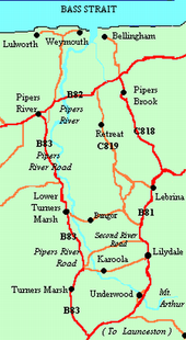
Karoola
Karoola is a small area located off Pipers RiverPipers River, Tasmania
Pipers River is a river which flows through northern Tasmania. It starts on Mount Arthur, near Lilydale. It runs through Hollybank Forest, a tourist attraction, before flowing through the outer reaches of Lilydale. It then proceeds through to Karoola, Lower Turners Marsh and then Pipers River town...
Road, about 6 km outside Lilydale town. Karoola means "fresh water" in the local aboriginal dialect. Facilities in the locality include a telephone box, an emergency fire shed, a Catholic church, a tennis court and a community hall. The local fire station is situated 5 km along Pipers River Road in Turners Marsh. There was once a general store but it was sold to a private buyer.
Underwood
Underwood is a locality just outside Lilydale. The Pipers River flows through the area.Hollybank Forest
Hollybank Forest is a 140-hectare reserve located on the Pipers River, near Underwood, 5 km outside Lilydale. It was originally used to source timber for sawmills in Launceston. Because the land was unable to be farmed the area was taken over by Forestry TasmaniaForestry Tasmania
Forestry Tasmania is a Tasmanian state government-owned corporation. It runs the state-owned forestry for tourism and logging including the Tahune Airwalk and Upper Florentine Valley.-Controversy:...
who have managed it since. There are a few short walks and a picnic area.
Lower Turners Marsh
Lower Turners Marsh is a locality between Lilydale town and Launceston. Lower Turners Marsh is located on Pipers River Road; the area is mostly farms and rural residences. Lower Turners Marsh is sometimes called Karoola.Turners Marsh
Turners Marsh is a locality on Pipers River Road, southwest of Lilydale and south of Lower Turners Marsh. Much of the area is bushThe Bush
"The bush" is a term used for rural, undeveloped land or country areas in certain countries.-Australia:The term is iconic in Australia. In reference to the landscape, "bush" describes a wooded area, intermediate between a shrubland and a forest, generally of dry and nitrogen-poor soil, mostly...
land, with some small farms. Turners Marsh has a carting track.
Sporting activities
As of 2011, Lilydale has an Australian rules footballAustralian rules football
Australian rules football, officially known as Australian football, also called football, Aussie rules or footy is a sport played between two teams of 22 players on either...
team, a bowls
Bowls
Bowls is a sport in which the objective is to roll slightly asymmetric balls so that they stop close to a smaller "jack" or "kitty". It is played on a pitch which may be flat or convex or uneven...
team and a small boxing club. It also has a swimming pool open at select times of the year.
The North-eastern Railway
Lilydale, Karoola and Turners Marsh are all situated on the branch railway from Launceston which opened to ScottsdaleScottsdale, Tasmania
Scottsdale is a town in the north-east of Tasmania, Australia. It lies on the Tasman Highway, around north-east of Launceston and south-east of the coastal town of Bridport. It is part of the Dorset Council....
on 9 September, 1889.