
Lillooet Lake
Encyclopedia
British Columbia
British Columbia is the westernmost of Canada's provinces and is known for its natural beauty, as reflected in its Latin motto, Splendor sine occasu . Its name was chosen by Queen Victoria in 1858...
, Canada
Canada
Canada is a North American country consisting of ten provinces and three territories. Located in the northern part of the continent, it extends from the Atlantic Ocean in the east to the Pacific Ocean in the west, and northward into the Arctic Ocean...
about 25 km in length and about 33.5 square kilometres (22 mi²) in area. It is about 95 km downstream from the source of the Lillooet River
Lillooet River
The Lillooet River is a major river of the southern Coast Mountains of British Columbia. It begins at Silt Lake, on the southern edge of the Lillooet Crown Icecap about 80 kilometres northwest of Pemberton and about 85 kilometres northwest of Whistler...
, which resumes its course after leaving Little Lillooet Lake, aka Tenas Lake (tenass in the Chinook Jargon means little). Immediately adjacent to the mouth of the upper Lillooet River
Lillooet River
The Lillooet River is a major river of the southern Coast Mountains of British Columbia. It begins at Silt Lake, on the southern edge of the Lillooet Crown Icecap about 80 kilometres northwest of Pemberton and about 85 kilometres northwest of Whistler...
is the mouth of the Birkenhead River
Birkenhead River
The Birkenhead River, formerly known as the Portage River, the Pole River and the Mosquito River, is a major tributary of the Lillooet River, which via Harrison Lake and the Harrison River is one of the major tributaries of the lower Fraser River...
and just upstream along the Lillooet
Lillooet River
The Lillooet River is a major river of the southern Coast Mountains of British Columbia. It begins at Silt Lake, on the southern edge of the Lillooet Crown Icecap about 80 kilometres northwest of Pemberton and about 85 kilometres northwest of Whistler...
is the confluence of the Green River, which begins at Green Lake in the resort area of Whistler
Whistler, British Columbia
Whistler is a Canadian resort town in the southern Pacific Ranges of the Coast Mountains in the province of British Columbia, Canada, approximately north of Vancouver...
.
The community of Pemberton
Pemberton, British Columbia
Pemberton is a village north of Whistler in the Pemberton Valley of British Columbia in Canada, with a population of 2,192. Until the 1960s the village could be accessed only by train but that changed when Highway 99 was built through Whistler and Pemberton.-Climate:The climate of Pemberton is...
is about 12 km upstream from the head of Lillooet Lake, while the eastern edge of the Mount Currie
Mount Currie, British Columbia
Mount Currie is a small community in British Columbia, 164 kilometres north-west of Vancouver and 40 kilometres north-west of Whistler along Highway 99....
Indian Reserve of the Lil'wat branch of the St'at'imc
St'at'imc
The St'át'imc are an Interior Salish people located in the southern Coast Mountains and Fraser Canyon region of the Interior of the Canadian province of British Columbia.St'át'imc culture displayed many features typical of Northwest Coast peoples: the...
people is the lakeshore itself. The eastern ramparts of the mountain ranges of Garibaldi Provincial Park
Garibaldi Provincial Park
Garibaldi Provincial Park, also called Garibaldi Park, is a wilderness park located in British Columbia, Canada, about 70 kilometres north of Vancouver. The park is located to the east of the Sea to Sky Highway between Squamish and Whistler and covers an area of over 1,950 square kilometres...
overlook Lillooet Lake from the west, while to the east are the northern reaches of the Lillooet Ranges
Lillooet Ranges
The Lillooet Ranges are the southeasternmost subdivision of the Pacific Ranges of the Coast Mountains of British Columbia. They are located between the drainage of the Lillooet River and Harrison Lake on the west and the canyon of the Fraser River on the east, and by the lowland coastal valley of...
which lie between the Lillooet-Harrison drainage and the Fraser River
Fraser River
The Fraser River is the longest river within British Columbia, Canada, rising at Fraser Pass near Mount Robson in the Rocky Mountains and flowing for , into the Strait of Georgia at the city of Vancouver. It is the tenth longest river in Canada...
.
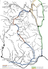
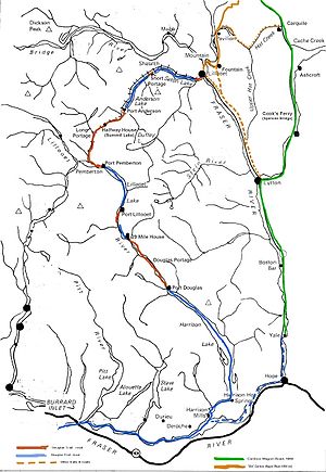
Lillooet Lake was part of the "Lakes Route" or Douglas Road
Douglas Road
The Douglas Road, aka the Lillooet Trail, Harrison Trail or Lakes Route, was a goldrush-era transportation route from the British Columbia Coast to the Interior...
, once if only briefly the principal route between the Coast and the Interior during the days of the Fraser Canyon Gold Rush
Fraser Canyon Gold Rush
The Fraser Canyon Gold Rush, began in 1858 after gold was discovered on the Thompson River in British Columbia at its confluence with the Nicoamen River. This was a few miles upstream from the Thompson's confluence with the Fraser River at present-day Lytton...
. Several steamers and innumerable smaller watercraft served the busy freight and passenger traffic in those days. The best-known and largest of these was the SS Prince of Wales, whose wreckage was visible on the shores of the lake near Mount Currie
Mount Currie, British Columbia
Mount Currie is a small community in British Columbia, 164 kilometres north-west of Vancouver and 40 kilometres north-west of Whistler along Highway 99....
for many years.