
Lilliesleaf
Encyclopedia
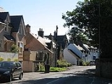
Lilliesleaf is a small village and civil parish
7 miles (11.3 km) south east of Selkirk in the Roxburghshire
area of Scottish Borders
of Scotland
.
To the north of Lilliesleaf is the Ale Water
which runs east to west. The wetland named "The Moss" is to the south of Lilliesleaf.
Other places nearby include Ancrum
, Ashkirk
, Belses
, Hassendean, Midlem, Minto House, Old Belses
, St Boswells, and Woll
.
The village's current population is around 301.
Lilliesleaf currently has two pubs, the Cross Keys and the Plough. There is also a cafe named "The Jammy Coo" which sells food, drinks, paintings and jewellery. Lilliesleaf has a primary school and one church in current use. There is no regular public transport in Lilliesleaf. It has no shops, but used to have a hardware shop, post office and a grocer, all of which closed down in the 1990s.
Civil parishes in Scotland
In Scotland, parishes, as units of local government, were abolished by the Local Government Act 1929. The geographical area is sometimes still referred to, however, for statistical purposes....
7 miles (11.3 km) south east of Selkirk in the Roxburghshire
Roxburghshire
Roxburghshire or the County of Roxburgh is a registration county of Scotland. It borders Dumfries to the west, Selkirk to the north-west, and Berwick to the north. To the south-east it borders Cumbria and Northumberland in England.It was named after the Royal Burgh of Roxburgh...
area of Scottish Borders
Scottish Borders
The Scottish Borders is one of 32 local government council areas of Scotland. It is bordered by Dumfries and Galloway in the west, South Lanarkshire and West Lothian in the north west, City of Edinburgh, East Lothian, Midlothian to the north; and the non-metropolitan counties of Northumberland...
of Scotland
Scotland
Scotland is a country that is part of the United Kingdom. Occupying the northern third of the island of Great Britain, it shares a border with England to the south and is bounded by the North Sea to the east, the Atlantic Ocean to the north and west, and the North Channel and Irish Sea to the...
.
To the north of Lilliesleaf is the Ale Water
Ale Water
The Ale Water is a tributary of the River Teviot, in the Scottish Borders area of Scotland. It rises at Henwoodie Hill and flows through Alemoor Loch.It meets the Teviot south of the village of Ancrum, and it runs through Ashkirk and Lilliesleaf....
which runs east to west. The wetland named "The Moss" is to the south of Lilliesleaf.
Other places nearby include Ancrum
Ancrum
Ancrum is a village in the Scottish Borders area of Scotland, north of Jedburgh and south of St Boswells....
, Ashkirk
Ashkirk
Ashkirk is a small village on the Ale Water, in the Scottish Borders area of Scotland. It is located in the former Selkirkshire, on the A7 road, approximately 6 miles each way between Selkirk to the north and Hawick to the south....
, Belses
Belses
Belses is a village on the Ale Water, in the Scottish Borders area of Scotland the former Selkirkshire. It is situated close to Old Belses, and lies south of St Boswells, west of Jedburgh, north of Hawick, and east of Selkirk....
, Hassendean, Midlem, Minto House, Old Belses
Old Belses
Old Belses is a village by the Ale Water, in the Parish of Ancrum, in the Scottish Borders of Scotland, in the former Roxburghshire.Other placenames relating to Belses include Belses Mill, Belses Muir, New Belses.Belses was a station on the Waverley Line....
, St Boswells, and Woll
Woll
Woll is a village on the Ale Water, off the A7, in the Ettrick Forest, north of Hawick, and south of Selkirk, Scottish Borders, in the Scottish Borders area of Scotland....
.
The village's current population is around 301.
Lilliesleaf currently has two pubs, the Cross Keys and the Plough. There is also a cafe named "The Jammy Coo" which sells food, drinks, paintings and jewellery. Lilliesleaf has a primary school and one church in current use. There is no regular public transport in Lilliesleaf. It has no shops, but used to have a hardware shop, post office and a grocer, all of which closed down in the 1990s.