
Laurel River Lake
Encyclopedia
Corbin, Kentucky
- Economy :Originally formed by L&N Railroad, rail transport was the backbone of the local economy in the first half of the twentieth century. While the railroad continues to play an important role, the decline of the rail industry in the latter half of the twentieth century, as well as the loss...
, in the USA
United States
The United States of America is a federal constitutional republic comprising fifty states and a federal district...
, is an reservoir
Reservoir
A reservoir , artificial lake or dam is used to store water.Reservoirs may be created in river valleys by the construction of a dam or may be built by excavation in the ground or by conventional construction techniques such as brickwork or cast concrete.The term reservoir may also be used to...
built in 1977 by the U.S. Army Corps of Engineers on the Laurel River, a tributary of the Cumberland River
Cumberland River
The Cumberland River is a waterway in the Southern United States. It is long. It starts in Harlan County in far southeastern Kentucky between Pine and Cumberland mountains, flows through southern Kentucky, crosses into northern Tennessee, and then curves back up into western Kentucky before...
, in the Daniel Boone National Forest
Daniel Boone National Forest
Daniel Boone National Forest is the only national forest completely within the boundary of Kentucky. Established in 1937, it was originally named the Cumberland National Forest, after the core region called the Cumberland Purchase Unit...
. The lake covers parts of Laurel
Laurel County, Kentucky
Laurel County is a county in the U.S. state of Kentucky. The population was 58,849 in the 2010 Census. Its county seat is London.The London Micropolitan Statistical Area includes all of Laurel County....
and Whitley
Whitley County, Kentucky
Whitley County is a county located in the state of Kentucky. 2005 census projections list its population at 38,029 . The county seat is at Williamsburg, though the largest city is Corbin, and the county's District Court sits in both cities...
counties.
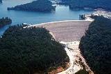
The 282 foot (86 m) high dam
Dam
A dam is a barrier that impounds water or underground streams. Dams generally serve the primary purpose of retaining water, while other structures such as floodgates or levees are used to manage or prevent water flow into specific land regions. Hydropower and pumped-storage hydroelectricity are...
was built between 1964 and 1974. It is a combination earth and rock-fill dam. Hydropower
Hydropower
Hydropower, hydraulic power, hydrokinetic power or water power is power that is derived from the force or energy of falling water, which may be harnessed for useful purposes. Since ancient times, hydropower has been used for irrigation and the operation of various mechanical devices, such as...
production began in 1977. As of 2006, it produced an average annual energy of 67 gigawatt hours of hydroelectricity
Hydroelectricity
Hydroelectricity is the term referring to electricity generated by hydropower; the production of electrical power through the use of the gravitational force of falling or flowing water. It is the most widely used form of renewable energy...
.
The Army Corps of Engineers and the Forest Service
United States Forest Service
The United States Forest Service is an agency of the United States Department of Agriculture that administers the nation's 155 national forests and 20 national grasslands, which encompass...
cooperate on developing recreational facilities around the reservoir. Today most of the lake is managed by the Forest Service as part of Daniel Boone National Forest. The Army Corps of Engineers manages the operation of the dam itself, and runs recreational facilities at the dam.
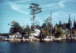
Laurel River Lake's drainage area is 282 square miles (730 km²). The area of the lake changes based on how full it is, but it is about 19 miles (31 km) long, with 206 miles (332 km) of shoreline. Its area ranges from about 5,600 to 6,060 acres (23 to 25 km²), with a maximum flood-control size of 6,650 acres (27 km²). The reservoir's storage capacity (volume) also changes, but is about 435000 acre.ft.