
Larapinta Trail
Encyclopedia
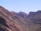
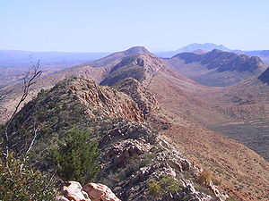
The Larapinta Trail is an extended walking track in the Northern Territory
, Australia
. Its total length covers 223 kilometres (138.6 mi) from East to West, with one end at Alice Springs and the other at Mount Sonder
, one of the territory's highest mountain
s. It follows the West MacDonnell Ranges, sometimes along the ridge line, other times on the plain below, in the West MacDonnell National Park
.
people, who have permitted tourists to visit the sites. In the 1990s the walk was only half as long, with the section between Mount Sonder and Ellery Big Hole completed at the turn of the millennium. Presently, the Northern Territory government is advertising the walk as Australia's best extended walk, competing with Western Australia
's Bibbulmun Track
and Tasmania
's Overland Track
and Western Arthurs track. The original Larapinta trail plan was to end at Mount Zeil on the Western end of the West MacDonnell National Park
. The terrain from Mount Sonder to Mount Zeil being hard to access by vehicle for rescue operations, the trail stopped at Mount Sonder. In September 2006, Belgian adventurer Louis-Philippe Loncke
walked without resupply from West of Mount Zeil to Alice Springs walking off track and joining the Larapinta trail at Redbank gorge.
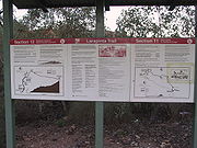 The trail is very well marked with kilometre posts marking both the distance to the next campsite
or section as well as the total length of the walk to go. There is a published leaflet
that details the requirements and attractions of completing each of the twelve sections and notice boards at the transition of each section. These notice boards also show elevation graphs of the walk and alert walkers to potential dangers.
There is a reasonable amount of water along the track, both naturally found and trucked in. There are only one or two places in which water cannot be obtained throughout the day, with frequent storage tanks. Signage suggests that all water should be treated by boiling it for 5 minutes or adding water treatment tablets.
No fires are allowed along the walk.
Northern Territory
The Northern Territory is a federal territory of Australia, occupying much of the centre of the mainland continent, as well as the central northern regions...
, Australia
Australia
Australia , officially the Commonwealth of Australia, is a country in the Southern Hemisphere comprising the mainland of the Australian continent, the island of Tasmania, and numerous smaller islands in the Indian and Pacific Oceans. It is the world's sixth-largest country by total area...
. Its total length covers 223 kilometres (138.6 mi) from East to West, with one end at Alice Springs and the other at Mount Sonder
Mount Sonder
Mount Sonder, or Rwetyepme, its Aboriginal name, is the fourth highest mountain in the Northern Territory, Australia at 1380 metres above sea level. Mount Zeil is the highest at 1531 metres, 27 kilometres to the west. It is west of Alice Springs along the MacDonnell Ranges in the West MacDonnell...
, one of the territory's highest mountain
Mountain
Image:Himalaya_annotated.jpg|thumb|right|The Himalayan mountain range with Mount Everestrect 58 14 160 49 Chomo Lonzorect 200 28 335 52 Makalurect 378 24 566 45 Mount Everestrect 188 581 920 656 Tibetan Plateaurect 250 406 340 427 Rong River...
s. It follows the West MacDonnell Ranges, sometimes along the ridge line, other times on the plain below, in the West MacDonnell National Park
West MacDonnell National Park
West MacDonnell is a national park in the Northern Territory , 1234 km south of Darwin. It extends along the MacDonnell Ranges west of Alice Springs....
.
Notable attractions
- Finke RiverFinke RiverThe Finke River is one of the largest rivers in central Australia. Its source is in the Northern Territory's MacDonnell Ranges, and the name Finke River is first applied at the confluence of the Davenport and Ormiston Creeks, just north of Glen Helen. From here the river meanders for approximately...
- Simpsons Gap
- Standley Chasm
- Ellery Creek Bighole
- Serpentine Gorge
- Ochre PitsOchre PitsThe Ochre Pits are a popular tourist destination in Australia's Northern Territory, approximately 50 kilometres west of Alice Springs along the Larapinta Trail....
- Ormiston PoundOrmiston PoundOrmiston Pound is a ring of mountains punctuating the MacDonnell Ranges, in the West MacDonnell National Park, approximately 135 kilometres west of Alice Springs in the Northern Territory, Australia...
- Redbank Gorge
- Glen Helen Gorge
- Tnorala Gosse BluffGosses Bluff craterGosses Bluff is thought to be the eroded remnant of an impact crater. It is located in the southern Northern Territory, near the centre of Australia, about west of Alice Springs and about to the northeast of Uluru...
- Palm Valley
History
The walk harbours many aboriginal sacred sites of the ArrernteArrernte people
The Arrernte people , known in English as the Aranda or Arunta, are those Indigenous Australians who are the original custodians of Arrernte lands in the central area of Australia around Mparntwe or Alice Springs in the Northern Territory. The Arrernte tribe has lived there for more than 20,000 years...
people, who have permitted tourists to visit the sites. In the 1990s the walk was only half as long, with the section between Mount Sonder and Ellery Big Hole completed at the turn of the millennium. Presently, the Northern Territory government is advertising the walk as Australia's best extended walk, competing with Western Australia
Western Australia
Western Australia is a state of Australia, occupying the entire western third of the Australian continent. It is bounded by the Indian Ocean to the north and west, the Great Australian Bight and Indian Ocean to the south, the Northern Territory to the north-east and South Australia to the south-east...
's Bibbulmun Track
Bibbulmun Track
The Bibbulmun Track is a long distance walk trail in Western Australia. It runs from Kalamunda, east of Perth to Albany and is almost 1000 km long...
and Tasmania
Tasmania
Tasmania is an Australian island and state. It is south of the continent, separated by Bass Strait. The state includes the island of Tasmania—the 26th largest island in the world—and the surrounding islands. The state has a population of 507,626 , of whom almost half reside in the greater Hobart...
's Overland Track
Overland Track
The Overland Track is one of Australia's most famous bush walks, situated in the Cradle Mountain-Lake St Clair National Park, Tasmania. More than 8000 walkers each year complete the track. Officially, the track runs for 65 km from Cradle Mountain to Lake St Clair. However, many choose to add...
and Western Arthurs track. The original Larapinta trail plan was to end at Mount Zeil on the Western end of the West MacDonnell National Park
West MacDonnell National Park
West MacDonnell is a national park in the Northern Territory , 1234 km south of Darwin. It extends along the MacDonnell Ranges west of Alice Springs....
. The terrain from Mount Sonder to Mount Zeil being hard to access by vehicle for rescue operations, the trail stopped at Mount Sonder. In September 2006, Belgian adventurer Louis-Philippe Loncke
Louis-Philippe Loncke
Louis-Philippe Loncke, is a Belgian explorer, adventurer and motivational speaker. In 2008, he achieved the world first crossing on foot of the length of the Simpson desert, which was a North to South traverse passing through its geographical center....
walked without resupply from West of Mount Zeil to Alice Springs walking off track and joining the Larapinta trail at Redbank gorge.
Amenities
Campsite
A campsite or camping pitch is a place used for overnight stay in the outdoors. In British English a campsite is an area, usually divided into a number of pitches, where people can camp overnight using tents or camper vans or caravans; this British English use of the word is synonymous with the...
or section as well as the total length of the walk to go. There is a published leaflet
Flyer (pamphlet)
__notoc__A flyer or flier, also called a circular, handbill or leaflet, is a form of paper advertisement intended for wide distribution and typically posted or distributed in public place....
that details the requirements and attractions of completing each of the twelve sections and notice boards at the transition of each section. These notice boards also show elevation graphs of the walk and alert walkers to potential dangers.
There is a reasonable amount of water along the track, both naturally found and trucked in. There are only one or two places in which water cannot be obtained throughout the day, with frequent storage tanks. Signage suggests that all water should be treated by boiling it for 5 minutes or adding water treatment tablets.
No fires are allowed along the walk.