

Kukeri Nunataks
Encyclopedia
Huron Glacier
Huron Glacier is a 7.7 km long and 3.5 km wide glacial flow on Livingston Island in the South Shetland Islands, Antarctica. The glacier is bounded by Bowles Ridge to the north, Wörner Gap to the west and Tangra Mountains to the south, receiving ice influx from several tributary glaciers...
, Livingston Island. Situated in the north foothills of Tangra Mountains
Tangra Mountains
Tangra Mountains form the principal mountain range of Livingston Island in the South Shetland Islands, Antarctica...
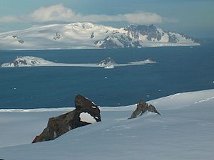
, 200 m away from each other.
Named after the Bulgarian folkloric masked ritual of ‘Kukeri
Kukeri
Kukeri is a traditional Bulgarian ritual to scare away evil spirits, with a costumed man performing the ritual. The costumes cover most of the body and include decorated wooden masks of animals and large bells attached to the belt...
.’
Location
The larger northeastern rock is located at 62°38′07.7"S 60°05′18"W which is 3.76 km east of Kuzman Knoll, 890 m north of Nestinari NunataksNestinari Nunataks
Nestinari Nunataks are a pair of rocky peaks of elevation 470 m and 520 m in middle Huron Glacier, Livingston Island in the South Shetland Islands, Antarctica...
, 2.68 km south-southeast of Atanasoff Nunatak
Atanasoff Nunatak
Atanasoff Nunatak is a nunatak, a sharp peak rising to 523 m in the east extremity of Bowles Ridge, Livingston Island, Antarctica. The peak sumounts Huron Glacier to the south and east, and Struma Glacier to the north...
and 1.97 km west of Godech Nunatak
Godech Nunatak
Godech Nunatak is a rocky 410m peak in lower Huron Glacier, in the north foothills of Tangra Mountains on Livingston Island, South Shetland Islands in Antarctica...
(Bulgarian mapping in 2005 and 2009 from the Tangra 2004/05
Tangra 2004/05
The Tangra 2004/05 Expedition was commissioned by the Antarctic Place-names Commission at the Ministry of Foreign Affairs of Bulgaria, managed by the Manfred Wörner Foundation, and supported by the Bulgarian Antarctic Institute, the Institute of Mathematics and Informatics at the Bulgarian Academy...
topographic survey).
Maps
- L.L. Ivanov et al. Antarctica: Livingston Island and Greenwich Island, South Shetland Islands. Scale 1:100000 topographic map. Sofia: Antarctic Place-names Commission of Bulgaria, 2005.
- L.L. Ivanov. Antarctica: Livingston Island and Greenwich, Robert, Snow and Smith Islands. Scale 1:120000 topographic map. Troyan: Manfred Wörner Foundation, 2009. ISBN 978-954-92032-6-4