
Kals am Großglockner
Encyclopedia
Kals am Großglockner is a town in the district of Lienz
in the exclave of East Tirol in Tyrol
, Austria
.
and Carinthia
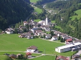
. Located in the valleys of Kalser and Iseltals on the Kalserbach river, Kals is dominated by mountains, and the famous Großglockner
mountain, the tallest mountain in all of Austria, is located partly in the municipality. Most of Kals is rugged and unusable (41.1%), with forests also prominent. Only 0.1% of the land is fields and pastures.
Lienz (district)
The Bezirk Lienz is an administrative district in Tyrol, Austria. It is the only district in East Tyrol. The district borders the Pinzgau in the north, the districts Spittal an der Drau and Hermagor in the east, Veneto in the south, and South Tyrol in the west.Area of the district is 2,019.87...
in the exclave of East Tirol in Tyrol
Tyrol (state)
Tyrol is a state or Bundesland, located in the west of Austria. It comprises the Austrian part of the historical region of Tyrol.The state is split into two parts–called North Tyrol and East Tyrol–by a -wide strip of land where the state of Salzburg borders directly on the Italian province of...
, Austria
Austria
Austria , officially the Republic of Austria , is a landlocked country of roughly 8.4 million people in Central Europe. It is bordered by the Czech Republic and Germany to the north, Slovakia and Hungary to the east, Slovenia and Italy to the south, and Switzerland and Liechtenstein to the...
.
Geography
Kals is located in northern East Tirol, near the border to SalzburgSalzburg (state)
Salzburg is a state or Land of Austria with an area of 7,156 km2, located adjacent to the German border. It is also known as Salzburgerland, to distinguish it from its capital city, also named Salzburg...
and Carinthia
Carinthia (state)
Carinthia is the southernmost Austrian state or Land. Situated within the Eastern Alps it is chiefly noted for its mountains and lakes.The main language is German. Its regional dialects belong to the Southern Austro-Bavarian group...
. Located in the valleys of Kalser and Iseltals on the Kalserbach river, Kals is dominated by mountains, and the famous Großglockner
Großglockner
The Grossglockner is, at 3,798 m above sea level, Austria's highest mountain and the highest mountain in the Alps east of the Brenner Pass...
mountain, the tallest mountain in all of Austria, is located partly in the municipality. Most of Kals is rugged and unusable (41.1%), with forests also prominent. Only 0.1% of the land is fields and pastures.
Municipal arrangement
Kals is divided into the following Katastralgemeinden: Unterpeischlach, Oberpeischlach, Staniska, Arnig, Lesach, Lana, Ködnitz, Glor-Berg, Großdorf, Unterburg, and Burg.History
The Kalser valley might have been settled before the Paleolithic Age. Kals was first mentioned on 19 August 1197. A large copper mine was begun in the 16th century here. Kals was the starting point for the first ascent of Großglockner in 1853.Main sights
- Church in Ködnitz built in 1439, with Classicist alterations made between 1818 and 1821.
- Church in Großdorf with a two-storeyed chapel and a Gothic spire