

Josefsdorf
Encyclopedia
| Josefsdorf | |
|---|---|
| Coat of arms | Map |
 |
 |
Location: 48°16′29"N 16°20′14"E |
|
Josefsdorf was an independent municipality
Municipality
A municipality is essentially an urban administrative division having corporate status and usually powers of self-government. It can also be used to mean the governing body of a municipality. A municipality is a general-purpose administrative subdivision, as opposed to a special-purpose district...
until 1892 and is today a part of Döbling
Döbling
Döbling is the 19th District in the city of Vienna, Austria . It is located on the north end from the central districts, north of the districts Alsergrund and Währing...
, the 19th district of Vienna. It is also one of the 89 Katastralgemeinde
Katastralgemeinde
A Katastralgemeinde , a German word , is a cadastral subdivision of municipalities in the nations of Austria, Croatia, the Czech Republic, Slovakia, the Italian provinces of South Tyrol, Trentino, Gorizia, Trieste, and in Slovenia.A cadastral community records property ownership in a cadastre,...
n.
Geography
Josefsdorf lies on one side of the KahlenbergKahlenberg
Kahlenberg is a mountain located in the 19th District within Vienna, Austria .-General:Kahlenberg lies in the Wienerwald and is one of the most popular destinations for day-trips from Vienna, offering a view over the entire city. Parts of Lower Austria can also be seen from Stefaniewarte at the...
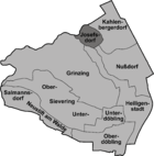
, on ground that slopes steeply towards Vienna. Covering an area of just 64.99 hectares, the Katastralgemeinde Josefsdorf is the smallest of the districts in Döbling. In statistical analyses conducted by the Austrian government, Josefsdorf is counted in the area Nußdorf-Kahlenbergerdorf.
History
The CamaldoleseCamaldolese
The Camaldolese monks and nuns are part of the Benedictine family of monastic communities which follow the way of life outlined in the Rule of St. Benedict, written in the 6th century...
laid the foundation for Josefsdorf in 1628. Ferdinand II
Ferdinand II, Holy Roman Emperor
Ferdinand II , a member of the House of Habsburg, was Holy Roman Emperor , King of Bohemia , and King of Hungary . His rule coincided with the Thirty Years' War.- Life :...
had invited the Camaldolese into the land following Polish marshal Nikolaus Wolsky’s supplication. The settlement consisted de facto of nothing but a monastery and was named Schweinsberg, after the mountain on which it was built. Schweinsberg is the original designation for the Kahlenberg. The Camaldolese settlement resembled a small village; two rows each of 20 plots clustered around a church and two yards. The monastery was dedicated to Saint Joseph
Saint Joseph
Saint Joseph is a figure in the Gospels, the husband of the Virgin Mary and the earthly father of Jesus Christ ....
. Following the dissolution of the hermitage on 4 February 1782, Edler Leopold von Kriegl obtained ownership over the land. The small houses that once belonged to the Camaldolese were sold off and von Kriegl opened a restaurant in what had earlier been the hospice. The Klosterneuburg Monastery provided one of its choir masters as a chaplain for the church. The modern-day St. Josefskirche (Saint Joseph’s Church) was sanctified in 1783. A cemetery was established in the nearby woods at the same time. The settlement was named Josefsdorf in 1784, in honour of Joseph II
Joseph II, Holy Roman Emperor
Joseph II was Holy Roman Emperor from 1765 to 1790 and ruler of the Habsburg lands from 1780 to 1790. He was the eldest son of Empress Maria Theresa and her husband, Francis I...
. However in 1809 the Josefsdorf parish was dissolved and the settlement was allocated to the town of Kahlenbergerdorf. Thereafter, Josefsdorf no longer had its own mayor and it was administered from Kahlenbergerdorf.
Over the years, Josefsdorf remained a very small settlement. In 1832, there were 53 people living in 27 houses; in 1890 there were 37 houses but one inhabitant fewer. The Fürst zu Liechtenstein, a Moravian noble, was the last lord of Josefsdorf.
In 1892, Josefsdorf, as part of the Kahlenbergerdorf
Kahlenbergerdorf
Kahlenbergerdorf was an independent municipality until 1892 and is today a part of Döbling, the 19th district of Vienna. It is also one of the 89 Katastralgemeinden.- Location :...
, along with the surrounding suburbs of Sievering
Sievering
Sievering is a suburb of Vienna and part of Döbling, the 19th district of Vienna. Sievering was created in 1892 out of the two erstwhile independent suburbs Untersievering and Obersievering. These still exist as Katastralgemeinden.- Geography :...
, Grinzing
Grinzing
Grinzing was an independent municipality until 1892 and is today a part of Döbling, the 19th district of Vienna.- Geography :- Location :...
, Oberdöbling
Oberdöbling
Oberdöbling was an independent municipality until 1892 and is today a part of Döbling, the 19th district of Vienna. It is also one of the 89 Katastralgemeinden.- Geography :...
, Unterdöbling
Unterdöbling
Unterdöbling was an independent municipality until 1892 and is today a part of Döbling, the 19th district of Vienna. It is also one of the 89 Katastralgemeinden.- Geography :...
, Nußdorf
Nußdorf, Vienna
Nußdorf was a separate municipality until 1892 and is today a suburb of Vienna in the 19th district of Döbling.- Location :Nußdorf lies on both banks of the Nußbach , where the brook meets the Danube Canal...
, Heiligenstadt
Heiligenstadt, Vienna
Heiligenstadt was an independent municipality until 1892 and is today a part of Döbling, the 19th district of Vienna.Heiligenstadt is one of the 10 municipalities in the Döbling District.- Geography :...
was integrated into the 19th district of Vienna, Döbling
Döbling
Döbling is the 19th District in the city of Vienna, Austria . It is located on the north end from the central districts, north of the districts Alsergrund and Währing...
.