
Iinan, Shimane
Encyclopedia
is a town
located in the Iishi District
in Shimane Prefecture
, Japan
. It was formed on January 1, 2005 from the merger of the towns of Tonbara and Akagi
, both from Iishi District
.
As of January 1, 2011 the town has a population
of 5,419 and a density
of 22.3 persons per km². The area is 242.84 km².
, the Gōno River flows to its west. The town is part of the Hiba-Dōgo-Taishaku Quasi-National Park.
Mountains: Mt. Oyorogi, Mt. Kotobiki, Mt. Mengame
Rivers: Kando River, Tonbara River, Akana River, Ono River (Tributary of Kando River)
Lakes:Lake Kijima (Kijima Dam lake)
(Population of Tonbara and Akagi added together before 2005)
*Roadside Station Tonbara
There is no railroad access to Iinan.
Towns of Japan
A town is a local administrative unit in Japan. It is a local public body along with prefecture , city , and village...
located in the Iishi District
Iishi District, Shimane
is a district located in Shimane, Japan.As of 2003, the district had an estimated population of 20,864 and a density of 38.00 persons per km². The total area is 242.84 km².-Mergers:...
in Shimane Prefecture
Shimane Prefecture
is a prefecture of Japan located in the Chūgoku region on Honshū island. The capital is Matsue. It is the second least populous prefecture in Japan, after its eastern neighbor Tottori. The prefecture has an area elongated from east to west facing the Chūgoku Mountain Range on the south side and to...
, Japan
Japan
Japan is an island nation in East Asia. Located in the Pacific Ocean, it lies to the east of the Sea of Japan, China, North Korea, South Korea and Russia, stretching from the Sea of Okhotsk in the north to the East China Sea and Taiwan in the south...
. It was formed on January 1, 2005 from the merger of the towns of Tonbara and Akagi
Akagi, Shimane
was a town located in Iishi District, Shimane, Japan.On January 1, 2005 Akagi was merged with the town of Tonbara, also from Iishi District, to form the new town of Iinan....
, both from Iishi District
Iishi District, Shimane
is a district located in Shimane, Japan.As of 2003, the district had an estimated population of 20,864 and a density of 38.00 persons per km². The total area is 242.84 km².-Mergers:...
.
As of January 1, 2011 the town has a population
Population
A population is all the organisms that both belong to the same group or species and live in the same geographical area. The area that is used to define a sexual population is such that inter-breeding is possible between any pair within the area and more probable than cross-breeding with individuals...
of 5,419 and a density
Population density
Population density is a measurement of population per unit area or unit volume. It is frequently applied to living organisms, and particularly to humans...
of 22.3 persons per km². The area is 242.84 km².
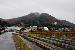
Geography
Located on the border of Shimane Prefecture and Hiroshima PrefectureHiroshima Prefecture
is a prefecture of Japan located in the Chūgoku region on Honshu island. The capital is the city of Hiroshima.- History :The area around Hiroshima was formerly divided into Bingo Province and Aki Province. This location has been a center of trade and culture since the beginning of Japan's recorded...
, the Gōno River flows to its west. The town is part of the Hiba-Dōgo-Taishaku Quasi-National Park.
Mountains: Mt. Oyorogi, Mt. Kotobiki, Mt. Mengame
Rivers: Kando River, Tonbara River, Akana River, Ono River (Tributary of Kando River)
Lakes:Lake Kijima (Kijima Dam lake)
Surrounding municipalities
- Shimane PrefectureShimane Prefectureis a prefecture of Japan located in the Chūgoku region on Honshū island. The capital is Matsue. It is the second least populous prefecture in Japan, after its eastern neighbor Tottori. The prefecture has an area elongated from east to west facing the Chūgoku Mountain Range on the south side and to...
- IzumoIzumo, Shimaneis a city located in Shimane, Japan. Izumo is known for Izumo soba noodles and the Izumo Taisha Shinto shrine.-Demographics:The modern city was founded on November 3, 1941....
- MisatoMisato, Shimaneis a town located in the Ōchi District in Shimane Prefecture, Japan. It was formed on October 1, 2004 from the merger of the village of Daiwa and the town of Ōchi....
- UnnanUnnan, Shimaneis a city located in Shimane Prefecture, Japan.Unnan was formed on November 1, 2004 from the merger of the towns of Daitō, Kamo and Kisuki, all from Ōhara District, the towns of Mitoya and Kakeya, and the village of Yoshida, all from Iishi District....
- ŌdaOda, Shimaneis a city located in Shimane, Japan.As of April 1, 2008, the city has an estimated population of 40,614 and the density of 90.2 persons per km². The total area is 436.11 km²...
- Izumo
- Hiroshima PrefectureHiroshima Prefectureis a prefecture of Japan located in the Chūgoku region on Honshu island. The capital is the city of Hiroshima.- History :The area around Hiroshima was formerly divided into Bingo Province and Aki Province. This location has been a center of trade and culture since the beginning of Japan's recorded...
- MiyoshiMiyoshi, Hiroshimais a city located in Hiroshima Prefecture, Japan.The city was founded on March 31, 1954.On April 1, 2004, Miyoshi City absorbed the towns of Kisa, Mirasaka and Miwa, the villages of Funo, Kimita and Sakugi, all from Futami District, and the town of Kōnu, from Kōnu District, to form the new city of...
- Miyoshi
Population
Iinan Population Change over Time(Population of Tonbara and Akagi added together before 2005)
| Year | Population |
|---|---|
| 1970 | 9,163 |
| 1975 | 8,180 |
| 1985 | 7,771 |
| 1985 | 7,650 |
| 1990 | 7,331 |
| 1995 | 6,893 |
| 2000 | 6,541 |
| 2005 | 5,979 |
| 2010 | 5,535 |
Roadside Stations
- Roadside Station Akagi Plateau
*Roadside Station Tonbara
There is no railroad access to Iinan.
Notable places
- Akana Castle
- It is an old castle located on top of a hill in the Akana area of the town.
- Mount Mengame
- Situated on the border of Hiroshima Prefecture and Shimane Prefecture, Mount Mengame has an elevation of 830.3m. It is known for being the only place in the Chūgoku Region in which Luehdorfia are found.
- Mount Kotobiki
- Mount Kotobiki has an elevation of 1014m. Near the summit of the mountain is a small shrine and a forest of beech trees. The name "Kotobiki" comes from the traditional Japanese musical instrument, the kotoKoto (musical instrument)The koto is a traditional Japanese stringed musical instrument, similar to the Chinese guzheng, the Mongolian yatga, the Korean gayageum and the Vietnamese đàn tranh. The koto is the national instrument of Japan. Koto are about length, and made from kiri wood...
.
- Mount Kotobiki has an elevation of 1014m. Near the summit of the mountain is a small shrine and a forest of beech trees. The name "Kotobiki" comes from the traditional Japanese musical instrument, the koto
- Akana Marshland
- The Akana Marshland is located in the Fukuda Area of the town, and is centered in Lake Nagao. It is known for having the largest forest of alders in the prefecture.
- Kotobiki Camp Area
- The Kotobiki Camp Area is located at the foot of Mount Kotobiki. It is open from late April to late October.