

Houses of Refuge in Florida
Encyclopedia

Florida
Florida is a state in the southeastern United States, located on the nation's Atlantic and Gulf coasts. It is bordered to the west by the Gulf of Mexico, to the north by Alabama and Georgia and to the east by the Atlantic Ocean. With a population of 18,801,310 as measured by the 2010 census, it...
to rescue and shelter ship-wrecked sailors. Five houses were constructed on the east coast in 1876, with five more added in 1885. There were also two Life Saving Stations built, one just south of the Jupiter Inlet, the other on the Gulf coast on Santa Rosa Island near Pensacola, Florida
Pensacola, Florida
Pensacola is the westernmost city in the Florida Panhandle and the county seat of Escambia County, Florida, United States of America. As of the 2000 census, the city had a total population of 56,255 and as of 2009, the estimated population was 53,752...
. A house of refuge was planned for the Marquesas Keys
Marquesas Keys
The Marquesas Keys form an uninhabited island group about 30 miles west of Key West, 4 miles in diameter, and inhabited by mangrove. They are an unincorporated area of Monroe County, Florida and belong to the Lower Keys Census County Division. They are protected as part of the Key West National...
, but was never put into commission. The houses were manned by civilian contractors who lived in the houses with their families. Most of these houses remained in service as life-saving stations until 1915 or later. Some of the locations became United States Coast Guard
United States Coast Guard
The United States Coast Guard is a branch of the United States Armed Forces and one of the seven U.S. uniformed services. The Coast Guard is a maritime, military, multi-mission service unique among the military branches for having a maritime law enforcement mission and a federal regulatory agency...
stations after the Life Saving Service was merged into the Coast Guard in 1915.
The houses were built of Florida pine, using 8x8 heartwood timbers for the foundation and frame. They were intended to withstand hurricanes, although several of them were destroyed by hurricanes in later years. The main floor was divided into four rooms, and a wide porch surrounded the building. The North room was the kitchen. Next was the dining room, living room and at the South end was the bedroom. All the stations were alike and all the Keepers used the rooms in the same manner. The station keeper's family occupied the main floor, and the attic was a dormitory for ship-wrecked sailors.
Locations
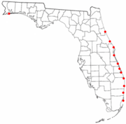
- Smith's Creek, 20 miles south of Matanzas InletMatanzas InletMatanzas Inlet is a channel in Florida between barrier islands connecting the Atlantic Ocean and the south end of the Matanzas River. It is south of St. Augustine, in the southern part of St. Johns County, at coordinates...
, 29°26′10"N 81°06′25"W - Mosquito Lagoon, east of the Mosquito LagoonMosquito LagoonMosquito Lagoon is located in the northern part of the Indian River Lagoon system and the Atlantic Intracoastal Waterway. It extends from Ponce de León Inlet in Volusia County, Florida, to the north end of Merritt Island. It connects to the Indian River via the Haulover Canal. The Lagoon divides...
, 28°51′30"N 80°46′20"W - Chester Shoal, 11 miles north of Cape CanaveralCape CanaveralCape Canaveral, from the Spanish Cabo Cañaveral, is a headland in Brevard County, Florida, United States, near the center of the state's Atlantic coast. Known as Cape Kennedy from 1963 to 1973, it lies east of Merritt Island, separated from it by the Banana River.It is part of a region known as the...
, 28°36′40"N 80°35′50"W - Cape Malabar, 30 miles south of Cape CanaveralCape CanaveralCape Canaveral, from the Spanish Cabo Cañaveral, is a headland in Brevard County, Florida, United States, near the center of the state's Atlantic coast. Known as Cape Kennedy from 1963 to 1973, it lies east of Merritt Island, separated from it by the Banana River.It is part of a region known as the...
, 28°03′10"N 80°32′45"W - Indian River or Bethel Creek, sixteen miles north of the Indian River Inlet (now known as the Fort Pierce InletFort Pierce Inlet State ParkFort Pierce Inlet State Park, a part of the Florida State Park system, is located just north of the Fort Pierce Inlet, on North Hutchinson Island, near Fort Pierce...
), 27°40′00"N 80°21′20"W - Indian River Inlet, on the south side of the Indian River Inlet (inlet closed in 1890's, the station was approximately 2.2 miles north of today's Fort Pierce Inlet at Peppers Park, St. Lucie County), 27°29′45"N 80°17′50"W
- Gilbert's BarHouse of Refuge at Gilbert's BarThe House of Refuge at Gilbert's Bar, also known as Gilbert's Bar House of Refuge, the House of Refuge Museum, or simply the House of Refuge, is an historic building located at 301 S.E. MacArthur Boulevard, on Hutchinson Island east of Stuart, Florida...
or Saint Lucie Rocks, two miles north of what is now the St. Lucie InletSt. Lucie Inlet, FloridaThe St. Lucie Inlet, Florida is located between Hutchinson Island and Jupiter Island in Martin County, Florida, at coordinates . The St. Lucie Inlet is one of six inlets into the Indian River Lagoon....
, near Stuart, FloridaStuart, FloridaStuart is the only incorporated city of Martin County, Florida, on Florida's Treasure Coast. The population was 14,633 at the 2000 census. As of 2007, the population recorded by the U.S. Census Bureau is 15,964....
, 27°12′00"N 80°09′50"W - Jupiter Inlet, near the Jupiter Inlet Lighthouse. This station was a Life Saving Station, rather than a House of Refuge, 26°55′40"N 80°04′00"W
- Orange Grove,26°27′30"N 80°03′20"W in what is now Delray Beach, FloridaDelray Beach, FloridaDelray Beach is a city in Palm Beach County, Florida, USA. As of the 2000 census, the city had a total population of 60,020. As of 2004, the population estimated by the U.S...
- Fort Lauderdale, in what is now Fort Lauderdale, FloridaFort Lauderdale, FloridaFort Lauderdale is a city in the U.S. state of Florida, on the Atlantic coast. It is the county seat of Broward County. As of the 2010 census, the city had a population of 165,521. It is a principal city of the South Florida metropolitan area, which was home to 5,564,635 people at the 2010...
, 26°08′00"N 80°06′00"W - Biscayne or Indian Creek, at what is now 72nd Street on Miami Beach, FloridaMiami Beach, FloridaMiami Beach is a coastal resort city in Miami-Dade County, Florida, United States, incorporated on March 26, 1915. The municipality is located on a barrier island between the Atlantic Ocean and Biscayne Bay, the latter which separates the Beach from Miami city proper...
, 25°54′10"N 80°08′00"W
The Gilbert's Bar House of Refuge
House of Refuge at Gilbert's Bar
The House of Refuge at Gilbert's Bar, also known as Gilbert's Bar House of Refuge, the House of Refuge Museum, or simply the House of Refuge, is an historic building located at 301 S.E. MacArthur Boulevard, on Hutchinson Island east of Stuart, Florida...
is the only one still standing, and is now a museum, operated by the Historical Society Of Martin County. It is open to visitors and has various re-enactments and history programs year round.
External links
- History of the U.S. Life-Saving Service URL retrieved 23 March 2010