
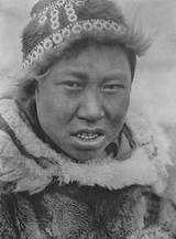
Hooper Bay, Alaska
Encyclopedia

Central Alaskan Yup'ik language
Central Alaskan Yup'ik or just Yup'ik is a Yupik language of the Eskimo language family, in turn a member of the Eskimo–Aleut language group, spoken in western and southwestern Alaska. Both in ethnic population and in number of speakers, Central Alaskan Yup'ik is the largest of the languages...
) is a city in Wade Hampton Census Area, Alaska
Wade Hampton Census Area, Alaska
Wade Hampton Census Area is a census area located in the U.S. state of Alaska. As of the 2000 census, the population was 7,028. It is part of the unorganized borough and therefore has no borough seat...
, United States. At the 2000 census the population was 1,014. The Boards of Canada
Boards of Canada
Boards of Canada are a Scottish electronic music duo consisting of brothers Mike Sandison and Marcus Eoin...
EP Hooper Bay
Hooper Bay (album)
Hooper Bay was purportedly an EP created by Boards of Canada, issued in both vinyl and cassette formats. The title refers to the small city of that name in Alaska, and all track titles on the album share a similar Alaskan theme...
was named after the city.
Geography
Hooper Bay is located at 61°31′44"N 166°5′46"W (61.528980, -166.096196). Hooper Bay is located 20 miles (32.2 km) south of Cape Romanzof, 25 miles (40.2 km) south of Scammon Bay in the Yukon-Kuskokwim Delta. The city is separated into two sections: a heavily built-up townsite located on gently rolling hills, and a newer section in the lowlands.According to the United States Census Bureau
United States Census Bureau
The United States Census Bureau is the government agency that is responsible for the United States Census. It also gathers other national demographic and economic data...
, the city has a total area of 8.8 square miles (22.8 km²), of which, 8.7 square miles (22.5 km²) of it is land and 0.1 square mile (0.258998811 km²) of it (0.91%) is water. The climate in Hooper Bay is maritime. The mean annual snowfall is 75 inches (1,905 mm), with a total precipitation of 16 inches (406.4 mm). Temperatures range between -25° and 79°F.
Demographics
As of the census of 2000, there were 1,014 people, 227 households, and 187 families residing in the city. The population density was 116.8 people per square mile (45.1/km²). There were 239 housing units at an average density of 27.5 per square mile (10.6/km²). The racial makeup of the city was 4.24% WhiteRace (United States Census)
Race and ethnicity in the United States Census, as defined by the Federal Office of Management and Budget and the United States Census Bureau, are self-identification data items in which residents choose the race or races with which they most closely identify, and indicate whether or not they are...
, 93.69% Native American
Race (United States Census)
Race and ethnicity in the United States Census, as defined by the Federal Office of Management and Budget and the United States Census Bureau, are self-identification data items in which residents choose the race or races with which they most closely identify, and indicate whether or not they are...
, and 2.07% from two or more races. 0.10% of the population were Hispanic
Race (United States Census)
Race and ethnicity in the United States Census, as defined by the Federal Office of Management and Budget and the United States Census Bureau, are self-identification data items in which residents choose the race or races with which they most closely identify, and indicate whether or not they are...
or Latino
Race (United States Census)
Race and ethnicity in the United States Census, as defined by the Federal Office of Management and Budget and the United States Census Bureau, are self-identification data items in which residents choose the race or races with which they most closely identify, and indicate whether or not they are...
of any race.
There were 227 households out of which 61.7% had children under the age of 18 living with them, 34.4% were married couples living together, 30.0% had a female householder with no husband present, and 17.6% were non-families. 15.4% of all households were made up of individuals and 0.9% had someone living alone who was 65 years of age or older. The average household size was 4.47 and the average family size was 4.97.
In the city, the age distribution of the population shows 49.2% under the age of 18, 9.0% from 18 to 24, 24.5% from 25 to 44, 11.5% from 45 to 64, and 5.8% who were 65 years of age or older. The median age was 18 years. For every 100 females there were 98.8 males. For every 100 females age 18 and over, there were 116.4 males.
The median income for a household in the city was $26,667, and the median income for a family was $27,500. Males had a median income of $31,250 versus $32,083 for females. The per capita income
Per capita income
Per capita income or income per person is a measure of mean income within an economic aggregate, such as a country or city. It is calculated by taking a measure of all sources of income in the aggregate and dividing it by the total population...
for the city was $7,841. About 28.4% of families and 27.9% of the population were below the poverty line, including 30.1% of those under age 18 and 31.6% of those age 65 or over.
2006 fire
On August 3, 2006, a fire destroyed approximately fifteen acres of the city before being extinguished. Destroyed in the blaze were thirty-five structures, including twelve homes, an elementary school, a middle school, a high school, a teacher housing complex, stores, offices and storage shelters. The fire left 70 people homeless, most of whom have stayed in Hooper Bay with friends and family.Further reading
- Gillham, Charles E., and Chanimun. Medicine Men of Hooper Bay: Or, The Eskimo's Arabian Nights. London: Batchworth Press, 1955.