
.gif)
Highway 147 (Wisconsin)
Encyclopedia
State Trunk Highway 147 (often called Highway 147, STH 147 or WIS 147) is a state highway in the U.S. state
of Wisconsin
. It runs in northwest-southeast in east central Wisconsin from near Maribel
to Two Rivers
.
U.S. state
A U.S. state is any one of the 50 federated states of the United States of America that share sovereignty with the federal government. Because of this shared sovereignty, an American is a citizen both of the federal entity and of his or her state of domicile. Four states use the official title of...
of Wisconsin
Wisconsin
Wisconsin is a U.S. state located in the north-central United States and is part of the Midwest. It is bordered by Minnesota to the west, Iowa to the southwest, Illinois to the south, Lake Michigan to the east, Michigan to the northeast, and Lake Superior to the north. Wisconsin's capital is...
. It runs in northwest-southeast in east central Wisconsin from near Maribel
Maribel, Wisconsin
Maribel is a village in Manitowoc County, Wisconsin, United States. The population was 264 at the 2000 census.-Geography:Maribel is located at ....
to Two Rivers
Two Rivers, Wisconsin
Two Rivers is a city in Manitowoc County, Wisconsin, United States. The population was 11,712 at the 2010 census. It is the birthplace of the ice cream sundae...
.
Route Description
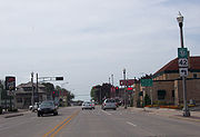
Highway 147's southern terminus ends at the corner of Washington and 22nd streets in Two Rivers. Highway 42 goes east toward Lake Michigan while 147 goes west. About 0.2 miles (0.3 km) later on 22nd street, 147 takes a right and becomes Forest Avenue. After going northwest for about 0.7 of a mile (1.13 km), Highway 147 continues northwest on what becomes Mishicot Road. Mishicot Road twists around for about 1.19 mi (1.91 km) until Highway 147 heads out of Two Rivers. The highway curves around for 3.15 miles (5.07 km) before visiting the Village of Mishicot. The road also becomes Main Street in Mishicot. Highway 147 continues on Main Street while crossing the East Twin River and County Highway B. About half of a mile outside of Mishicot, the road becomes mostly rural until the northern terminus where I-43 goes north and south and County Road Z continues westward to Maribel and Wayside.