

Harburg Hills
Encyclopedia
Lower Saxony
Lower Saxony is a German state situated in north-western Germany and is second in area and fourth in population among the sixteen states of Germany...
and the southern part of the city state of Hamburg
Hamburg
-History:The first historic name for the city was, according to Claudius Ptolemy's reports, Treva.But the city takes its modern name, Hamburg, from the first permanent building on the site, a castle whose construction was ordered by the Emperor Charlemagne in AD 808...
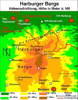
. They are up to 155 metres (508.5 ft) high.
Geography and history
The Harburg Hills lie northwest of the Lüneburg HeathLüneburg Heath
The Lüneburg Heath is a large area of heath, geest and woodland in northeastern part of the state of Lower Saxony in northern Germany. It forms part of the hinterland for the cities of Hamburg, Hanover, and Bremen and is named after the town of Lüneburg. Most of the area is a nature reserve...
in the Lower Saxon
Lower Saxony
Lower Saxony is a German state situated in north-western Germany and is second in area and fourth in population among the sixteen states of Germany...
district of Landkreis Harburg and in the Hamburg quarters of Eißendorf, Hausbruch, Heimfeld, Marmstorf and Neugraben-Fischbek
Neugraben-Fischbek
Neugraben-Fischbek is a quarter of Hamburg, Germany belongs to the borough Harburg. The quarter consists of the old settlements Neugraben and Fischbek, and the more recently constructed area Neuwiedenthal.-History:-History of Fischbek:...
within the Harburg borough. Thus they are located between the actual city of Hamburg
Hamburg
-History:The first historic name for the city was, according to Claudius Ptolemy's reports, Treva.But the city takes its modern name, Hamburg, from the first permanent building on the site, a castle whose construction was ordered by the Emperor Charlemagne in AD 808...
to the north, Seevetal
Seevetal
Seevetal is a municipality in the district of Harburg, in Lower Saxony, Germany. It is situated approx. 20 km south of Hamburg, and 15 km west of Winsen . Its seat is in the village Hittfeld...
to the east, the Lüneburg Heath to the southeast, Handeloh
Handeloh
- Location :Handeloh lies between the rivers Seeve and Este, south of Buchholz in der Nordheide. The Harburg Hills lie to the northwest and the Lüneburg Heath Nature Reserve to the southeast...
, Welle and Otter to the south, Tostedt
Tostedt
Tostedt is a municipality in the district of Harburg, in Lower Saxony, Germany. It is situated approx. 35 km southwest of Hamburg, and 12 km southwest of Buchholz in der Nordheide....
and Buchholz in der Nordheide
Buchholz in der Nordheide
Buchholz in der Nordheide is the largest town in the district of Harburg, in Lower Saxony, Germany. It is situated approx. 25 km southwest of Hamburg.-Geography:Buchholz is home to the Brunsberg, the region's highest mountain...
to the southwest, Hollenstedt
Hollenstedt
Hollenstedt is a municipality in the district of Harburg, in Lower Saxony, Germany. It is situated approx. 25 km southwest of Hamburg, and 12 km south of Buxtehude....
and Beckdorf
Beckdorf
Beckdorf is a municipality in the district of Stade, Lower Saxony, Germany.It belonged to the Prince-Archbishopric of Bremen. In 1648 the Prince-Archbishopric was transformed into the Duchy of Bremen, which was first ruled in personal union by the Swedish and from 1715 on by the Hanoverian Crown....
to the west and Neu Wulmstorf
Neu Wulmstorf
Neu Wulmstorf is a municipality in the district of Harburg, in Lower Saxony, Germany. It is situated approx. 15 km southwest of Hamburg-City right on the border of Hamburg state, and 7 km east of Buxtehude...
to the northwest. At the centre of this hill country is the municipal district of Rosengarten (which consists of ten separate villages and covers an area of some 64 km² (25 sq. miles)). The geographic centre of the Harburg Hills is the Buchholz motorway (Autobahn) interchange on the A 1. The hills are framed by the on River Seeve in the east and the River Este in the west.
The Harburg Hills are end moraines that were formed in the Saalian glaciation and Weichselian Ice Age. They are a popular recreation area today.
Terrain
The Harburg Hills form a landscape of hilly forests, heaths and farmland. In the extreme north of this hill country, where they are called the "The Black Hills" (Die Schwarzen Berge) and are very rugged for North Germany, may be found the nature reserves of the Fischbeker Heide and Neugrabener Heide as well as the Schwarze Berge Deer Park. The southern end of these hills is called the Lohberge.Access
The area is crossed by the A 1 and A 261 Autobahns; junctions Neu Wulmstorf-Rade, Buchholz-Dibbersen (both on the A 1) and Rosengarten-Tötensen (A 261) enabling easy access to the hills. The A 7 runs through the northeastern part of the region; leave at the Marmstorf exit.Hills
- Hülsenberg (155 m), Harburg district
- Gannaberg (150 m), Harburg district, Langenrehm village (with the Rosengarten radio and TV tower)
- Brunsberg (129 m), Harburg district
- KiekebergKiekebergThe Kiekeberg is, at 127 metres above sea level, one of the more prominent hills in the Harburg Hills in north Germany. It is located in the parish of Ehestorf in the municipality of Rosengarten in the district of Harburg in the southern foothills of the range, which is also known as The Black...
(127 m), Harburg district, Black Hills (Schwarze Berge) - HasselbrackHasselbrackThe Hasselbrack, at , is the highest point in the state of Hamburg, Germany.It is located on the southern border of the city state with Lower Saxony in the "Black Hills" , a northern outlier of the Harburg Hills in the quarter of Neugraben-Fischbek...
(116,2 m), highest elevation in Hamburg. - Fistelberge (107 m), Harburg district, Black Hills
- Flidderberg (107 m), Harburg district, Lohberge