
Hakha
Encyclopedia
Hakha is the capital of Chin State
in Burma. Its located in the northeast in Chin State
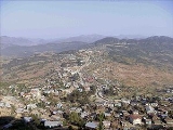
. The vernacular name of the city was Halkha. The total area of Hakha is about 12.5 mi2. The town of Hakha, more than 6,000 feet above the sea level, is founded on a small highland plateau. Although it is relative small in land area, it is the largest town and Capital city of the whole state and its plateau
is significantly larger than that of other towns in Chin State. It's widely believed that Hakha has enough land and full capacity to extend as much as ten times than its current township area. In other words, Hakha can house even if other eight townships and three sub-townships in the present Chin State are moved to Hakha; because it can expand to Mount Ngau Thu and as far as Hniar Lawn and Nabual village. [As Chin State
is quite hilly, Hakha is built on the slope of a large mountain, in a U shape. There is only one main road running along the middle of the city, in a curve U, and the whole city is built along this road. Another road runs from the middle of the city, for a short while, forming the foot of U. Hakha is in the center of Chin State and it is connected with Thantlang
, Falam, Gangaw
and Matupi
by truck roads.
. The area was ruled by local chiefs for many generations and it consisted of more than 600 houses when the British troops landed Hakha in 1889.
The British occupied Hakha on January 19, 1890, as part of their operation to "subdue the wild tribes" in the Arakan
Hills Division, as the area was then called. The British government later established a sub-divisional office and Hakha became a town a few years later.
The first American Baptist missionary couple, Reverend and Mrs Arthur Carson, arrived in Hakha on March 15, 1899 and opened a mission station. Later other missionaries joined them and did extensive mission works throughout the Chin Hills and converted most of the Northern Chin State
to Christianity within a century. This missionary work brought education, development
, social and economic changes, and health improvement to the Chin people
.
During the Second World War, Hakha was captured by Japanese troops on November 11, 1943; it was later recaptured by British troops.
When Burma got independence from British control in 1948, Hakha became an important city as the center for one of the sis subdivisions in the Chin Special Division and Falam was the capital at that time. The Chin Special Division was abolished and formed the Chin State
in 1974 and Hakha became the capital for the Chin State. That brought an influx of government workers, housing development and extension of the city. Hakha eventually became the largest city in the Chin State with about 20,000 people.
.
January is the coldest month of the year with a mean temperature of around 27 degree
s Celsius. April is the hottest month
at a mean
of 36 degrees Celsius.
The total rainfall is about 86.22 inches every year.
It is quite cold during the winter months. Sometimes, the temperature drops to as low as minus two degree Celsius. It is also very windy in winter. The whole city is foggy in the morning and in the evening. The weather is excruciatingly cold. During the month of January, 2009 there was a cold wave
that hit Burma. The government's mouth-piece newspaper, Myanma Ahlin,however, did not carry any story on the possible 'Cold Wave' passing through the country, though it mentioned that temperatures have dropped up to 0 degree in Hakha Town, capital city of Chin state in north-west Burma. According to medical experts, the 'Cold Wave
' could cause severe health problems especially to children and elderly people and there are chances of some being paralyzed. Besides, cardiac and kidney
problems could also grow worse.
Burmese officials downplayed the warning issued by Indian officials. Tun Lwin, director
of Burma's Department of Meteorology and Hydrology, said the cold spell was not unusual for this time of year."It is likely to be cold up until the end of the month but it is a regular cold season. It is not really anything new. There is no record breaking temperature," Tun Lwin said. The Burmese meteorology department has issued issued daily weather reports since 1988, but it has never issued warnings of predicted heat waves or cold snaps.
Chin State
Chin State is a state located in western Burma . The Chin State is bordered by Rakhine State in the south, Bangladesh in south-west, Sagaing Division and Magway Division in the east, Indian state of Manipur in the north and Indian state of Mizoram in the west. The Chin ethnic group make up the...
in Burma. Its located in the northeast in Chin State
Chin State
Chin State is a state located in western Burma . The Chin State is bordered by Rakhine State in the south, Bangladesh in south-west, Sagaing Division and Magway Division in the east, Indian state of Manipur in the north and Indian state of Mizoram in the west. The Chin ethnic group make up the...
. The vernacular name of the city was Halkha. The total area of Hakha is about 12.5 mi2. The town of Hakha, more than 6,000 feet above the sea level, is founded on a small highland plateau. Although it is relative small in land area, it is the largest town and Capital city of the whole state and its plateau
Plateau
In geology and earth science, a plateau , also called a high plain or tableland, is an area of highland, usually consisting of relatively flat terrain. A highly eroded plateau is called a dissected plateau...
is significantly larger than that of other towns in Chin State. It's widely believed that Hakha has enough land and full capacity to extend as much as ten times than its current township area. In other words, Hakha can house even if other eight townships and three sub-townships in the present Chin State are moved to Hakha; because it can expand to Mount Ngau Thu and as far as Hniar Lawn and Nabual village. [As Chin State
Chin State
Chin State is a state located in western Burma . The Chin State is bordered by Rakhine State in the south, Bangladesh in south-west, Sagaing Division and Magway Division in the east, Indian state of Manipur in the north and Indian state of Mizoram in the west. The Chin ethnic group make up the...
is quite hilly, Hakha is built on the slope of a large mountain, in a U shape. There is only one main road running along the middle of the city, in a curve U, and the whole city is built along this road. Another road runs from the middle of the city, for a short while, forming the foot of U. Hakha is in the center of Chin State and it is connected with Thantlang
Thantlang
Thantlang ; also Tlangtlang, Thlangtlang, Htantlang and Htantalan) is a town and the administrative center of Htantlang Township in Chin State, western Burma .-External links:* Maplandia.com...
, Falam, Gangaw
Gangaw
Gangaw is a town of Gangaw Township in Gangaw District in the Magway Division in Myanmar. Gangaw is also known as the City of Yaw, a certain region in Myanmar including Gangaw, Tilin, Saw and villages around them...
and Matupi
Matupi
Matupi is a town in Chin State in western Burma , in Southeast Asia.Matupi is the second capital City, one of the townships of Chin State of West Myanmar, South-east Asia...
by truck roads.
History
Hakha was founded in around A.D 1400 by the Lai ethnic groupEthnic group
An ethnic group is a group of people whose members identify with each other, through a common heritage, often consisting of a common language, a common culture and/or an ideology that stresses common ancestry or endogamy...
. The area was ruled by local chiefs for many generations and it consisted of more than 600 houses when the British troops landed Hakha in 1889.
The British occupied Hakha on January 19, 1890, as part of their operation to "subdue the wild tribes" in the Arakan
Rakhine State
Rakhine State is a Burmese state. Situated on the western coast, it is bordered by Chin State in the north, Magway Region, Bago Region and Ayeyarwady Region in the east, the Bay of Bengal to the west, and the Chittagong Division of Bangladesh to the northwest. It is located approximately between...
Hills Division, as the area was then called. The British government later established a sub-divisional office and Hakha became a town a few years later.
The first American Baptist missionary couple, Reverend and Mrs Arthur Carson, arrived in Hakha on March 15, 1899 and opened a mission station. Later other missionaries joined them and did extensive mission works throughout the Chin Hills and converted most of the Northern Chin State
Chin State
Chin State is a state located in western Burma . The Chin State is bordered by Rakhine State in the south, Bangladesh in south-west, Sagaing Division and Magway Division in the east, Indian state of Manipur in the north and Indian state of Mizoram in the west. The Chin ethnic group make up the...
to Christianity within a century. This missionary work brought education, development
Human development (humanity)
Human development in the scope of humanity, specifically international development, is an international and economic development paradigm that is about much more than the rise or fall of national incomes. People are the real wealth of nations...
, social and economic changes, and health improvement to the Chin people
Chin people
The Chin , known as the Kuki in Assam, are one of the ethnic groups in Burma. The Chins are found mainly in western part of Burma and numbered circa 1.5 million. They also live in nearby Indian states of Nagaland, Mizoram and Manipur and Assam. Owing to Mizo influence and Baptist missionaries'...
.
During the Second World War, Hakha was captured by Japanese troops on November 11, 1943; it was later recaptured by British troops.
When Burma got independence from British control in 1948, Hakha became an important city as the center for one of the sis subdivisions in the Chin Special Division and Falam was the capital at that time. The Chin Special Division was abolished and formed the Chin State
Chin State
Chin State is a state located in western Burma . The Chin State is bordered by Rakhine State in the south, Bangladesh in south-west, Sagaing Division and Magway Division in the east, Indian state of Manipur in the north and Indian state of Mizoram in the west. The Chin ethnic group make up the...
in 1974 and Hakha became the capital for the Chin State. That brought an influx of government workers, housing development and extension of the city. Hakha eventually became the largest city in the Chin State with about 20,000 people.
Geography and climate
The city is 6120 feet (1,865.4 m) above sea level and it lies at the foot of Rung Tlang (Mt. Rung), which is about 7543 feet (2,299.1 m) high, and is one of the most famous and beautiful mountain peaks in the Chin StateChin State
Chin State is a state located in western Burma . The Chin State is bordered by Rakhine State in the south, Bangladesh in south-west, Sagaing Division and Magway Division in the east, Indian state of Manipur in the north and Indian state of Mizoram in the west. The Chin ethnic group make up the...
.
January is the coldest month of the year with a mean temperature of around 27 degree
Degree (temperature)
The term degree is used in several scales of temperature. The symbol ° is usually used, followed by the initial letter of the unit, for example “°C” for degree Celsius...
s Celsius. April is the hottest month
Month
A month is a unit of time, used with calendars, which was first used and invented in Mesopotamia, as a natural period related to the motion of the Moon; month and Moon are cognates. The traditional concept arose with the cycle of moon phases; such months are synodic months and last approximately...
at a mean
Mean
In statistics, mean has two related meanings:* the arithmetic mean .* the expected value of a random variable, which is also called the population mean....
of 36 degrees Celsius.
The total rainfall is about 86.22 inches every year.
It is quite cold during the winter months. Sometimes, the temperature drops to as low as minus two degree Celsius. It is also very windy in winter. The whole city is foggy in the morning and in the evening. The weather is excruciatingly cold. During the month of January, 2009 there was a cold wave
Cold wave
A cold wave is a weather phenomenon that is distinguished by a cooling of the air. Specifically, as used by the U.S. National Weather Service, a cold wave is a rapid fall in temperature within a 24 hour period requiring substantially increased protection to agriculture, industry, commerce, and...
that hit Burma. The government's mouth-piece newspaper, Myanma Ahlin,however, did not carry any story on the possible 'Cold Wave' passing through the country, though it mentioned that temperatures have dropped up to 0 degree in Hakha Town, capital city of Chin state in north-west Burma. According to medical experts, the 'Cold Wave
Cold wave
A cold wave is a weather phenomenon that is distinguished by a cooling of the air. Specifically, as used by the U.S. National Weather Service, a cold wave is a rapid fall in temperature within a 24 hour period requiring substantially increased protection to agriculture, industry, commerce, and...
' could cause severe health problems especially to children and elderly people and there are chances of some being paralyzed. Besides, cardiac and kidney
Kidney
The kidneys, organs with several functions, serve essential regulatory roles in most animals, including vertebrates and some invertebrates. They are essential in the urinary system and also serve homeostatic functions such as the regulation of electrolytes, maintenance of acid–base balance, and...
problems could also grow worse.
Burmese officials downplayed the warning issued by Indian officials. Tun Lwin, director
Executive director
Executive director is a term sometimes applied to the chief executive officer or managing director of an organization, company, or corporation. It is widely used in North American non-profit organizations, though in recent decades many U.S. nonprofits have adopted the title "President/CEO"...
of Burma's Department of Meteorology and Hydrology, said the cold spell was not unusual for this time of year."It is likely to be cold up until the end of the month but it is a regular cold season. It is not really anything new. There is no record breaking temperature," Tun Lwin said. The Burmese meteorology department has issued issued daily weather reports since 1988, but it has never issued warnings of predicted heat waves or cold snaps.
Ministries and Government Organizations
http://www.myanmarteldir.com/government/other_gov.asp?id=13External links
- Hakha Bible
- Lai Wikipedia