

Graham Lakes, Minnesota
Encyclopedia
Graham Lakes
The Graham Lakes are a pair of lakes located in the northeastern corner of Nobles County, MinnesotaNobles County, Minnesota
Nobles County is a county located in the U.S. state of Minnesota. As of 2010, the population was 21,378. Its county seat is Worthington.-Geography:...
. The lakes are known as West Graham Lake and East Graham Lake. West Graham Lake is an oval shaped body of water that extends east-to-west slightly more than one mile (1.6 km). The north-to-south width of the lake is approximately 3/4 of a mile. The area of West Graham Lake is 519.28 acres (2.1 km²), the average depth is 5 feet (1.5 m), and the maximum depth is 8 feet (2.4 m). The elevation of West Graham Lake is 1438.7 feet (438.5 m), or 438.52 meters. East Graham Lake is a longer, narrower lake that extends from northeast-to-southwest for 1 1/2 miles. Its width is less than 1/2 mile. The area of East Graham Lake is 511.32 acres (2.1 km²), the average depth is 5 feet (1.5 m), and the maximum depth is 8 feet (2.4 m). The elevation of East Graham Lake is 1435.08 feet (437.4 m), or 437.41 meters. A small creek runs from West Graham Lake and empties into East Graham Lake. Another creek runs from East Graham Lake, and eventually flows into the Des Moines River
Des Moines River
The Des Moines River is a tributary river of the Mississippi River, approximately long to its farther headwaters, in the upper Midwestern United States...
.
History
In the month of May, 1867, a pioneer named Stephen Muck pushed out into the unsettled Graham Lakes region and squatted on land on the bank of West Graham Lake. When surveyed, this land proved to be on section 22 of Graham Lakes Township. There he built a log structure from timber growing near the lake, the first house of wood in the county. In the fall of 1867, Muck brought his family from Jackson County, MinnesotaJackson County, Minnesota
As of the census of 2000, there were 11,268 people, 4,556 households, and 3,116 families residing in the county. The population density was 16 people per square mile . There were 5,092 housing units at an average density of 7 per square mile...
. He earned his livelihood by trapping for a few years, then turned to farming. He lived continuously on his farm from 1867 until the time of his death in 1897. Stephen Muck was the very first permanent resident of Nobles County.
The first town to appear on any map of Nobles County was a curious place called Gretchtown. According to an 1856 map - a map drawn 11 years before the arrival of Stephen Muck - Gretchtown was located on the south bank of West Graham Lake, very near to Muck's claim. Rumors of a railroad to be built through southwestern Minnesota had circulated in the 1850s, and even though no survey had been taken for the railroad, the town of Gretchtown had been created - at least on paper - to serve as a stopping point. When Nobles County was formally created by the Minnesota legislature on May 23, 1857, Gretchtown was brielfy designated as the county seat of Nobles County, an imaginary county seat for a county that, at that time, had no residents.
When a route for the St. Paul and Sioux City Railway was surveyed in 1871, it was located far south of the Graham Lakes region. No towns or villages existed in Graham Lakes Township
Graham Lakes Township, Minnesota
Graham Lakes Township is a township in Nobles County, Minnesota, United States. The population was 251 at the 2000 census.-Geography:According to the United States Census Bureau, the township has a total area of , of which, of it is land and of it is water...
until 1879 when Kinbrae
Kinbrae, Minnesota
As of the census of 2000, there were 21 people, 10 households, and 6 families residing in the city. The population density was 25.4 people per square mile . There were 14 housing units at an average density of 16.9 per square mile...
and Dundee
Dundee, Minnesota
Dundee is a city in Nobles County, Minnesota, United States The population was 68 at the 2010 census.-Geography:According to the United States Census Bureau, the city has a total area of , all of it land. Dundee is located in the extreme northeastern corner of Nobles County...
were established. Neither town grew beyond a few hundred residents. Thus, the Graham Lakes region has remained entirely rural, and the lake shores of both East Graham Lake and West Graham Lake remain undeveloped.
These lakes were first noted on Joseph Nicollet
Joseph Nicollet
Joseph Nicolas Nicollet , also known as Jean-Nicolas Nicollet, was a French geographer and mathematician known for mapping the Upper Mississippi River basin during the 1830s....
's 1842 map based upon his explorations of the late 1830s and early 1840s. Nicollet named the lakes after Joseph Duncan Graham. Graham served as a commissioner for the survey of the northeast segment of the boundary between the United States and Canada from 1840 until 1843.
Fishing
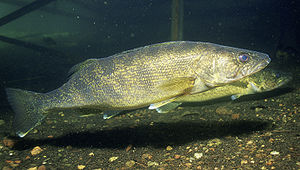
Walleye
Walleye is a freshwater perciform fish native to most of Canada and to the northern United States. It is a North American close relative of the European pikeperch...
and northern pike
Northern Pike
The northern pike , is a species of carnivorous fish of the genus Esox...
and secondarily for black crappie and yellow perch
Yellow perch
The yellow perch is a species of perch found in the United States and Canada, where it is often referred to by the shortform perch. Yellow perch look similar to the European perch, but are paler and more yellowish, with less red in the fins. They have six to eight dark, vertical bars on their sides...
. A population assessment was conducted during the week of June 4, 2007 using 3 gill nets and 8 trap nets. Black Crappies ranged from 7.4 inches (188 mm) to 13 inches (330.2 mm), and their numbers were the highest since sampling of the lake has been conducted. Northern Pike ranged from 17.6 inches (447 mm) to 30 inches (762 mm). Walleye were also abundant, and 59% of those sampled were 14 inches (355.6 mm) or greater. Most fish from East Graham Lake are safe to eat. However, pregnant women, women who may become pregnant and children under age 15 are advised to refrain from eating walleye more than once per week due to mercury levels. West Graham is primarily managed for walleye with black crappie and channel catfish
Channel catfish
Channel catfish, Ictalurus punctatus, is North America's most numerous catfish species. It is the official fish of Missouri, Iowa, Nebraska, Kansas, and Tennessee, and is informally referred to as a "channel cat". In the United States they are the most fished catfish species with approximately 8...
as secondary species. Walleye fry and fingerlings are stocked in successive years, with the third year left blank. A population assessment conducted on June 4, 2007 found that walleye range from 6.9 to 20 inches (508 mm) in length. Black crappies range from 5.8 inches (147.3 mm) to 11.9 inches (302.3 mm). The average black crappie swimming in West Graham Lake is thought to be nearly 1/2 pound. Channel catfish average 13.3 inches (337.8 mm). There are no advisories for consumption of fish from West Graham Lake.