

Governor Hutchinson's Field
Encyclopedia
Governor Hutchinson's Field is a nature reserve
located in Milton, Massachusetts
. The field is owned by The Trustees of Reservations
.
and Quincy
and a ha-ha constructed by the governor which is now on the property of St. Michael's Episcopal Church, a block away from the field. A ha-ha is a sunken wall which permits unblocked views, while still serving functions of a wall such as delineating a border and preventing livestock from crossing.
The ha-ha was added to the National Register of Historic Places
as Governor Thomas Hutchinson's Ha-ha in 1975.
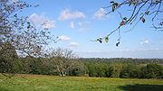
The field, with its wonderful view of Boston, is on Adams Street at the top of Milton Hill, opposite the Capt. Robert B. Forbes House and the Dr. Amos Holbrook House
, both of which are also on the National Register of Historic Places.
Nature reserve
A nature reserve is a protected area of importance for wildlife, flora, fauna or features of geological or other special interest, which is reserved and managed for conservation and to provide special opportunities for study or research...
located in Milton, Massachusetts
Milton, Massachusetts
Milton is a town in Norfolk County, Massachusetts, United States and part of the Greater Boston area. The population was 27,003 at the 2010 census. Milton is the birthplace of former U.S. President George H. W. Bush and architect Buckminster Fuller. Milton also has the highest percentage of...
. The field is owned by The Trustees of Reservations
The Trustees of Reservations
The Trustees of Reservations is a non-profit land conservation and historic preservation organization dedicated to preserving natural and historical places in the Commonwealth of Massachusetts. It is the oldest regional land trust in the world and has 100,000 dues-paying members...
.
History
In 1734, Thomas Hutchinson, last civilian royal governor of Massachusetts, built a country estate on the property. The two remaining parts of the estate are the field, which affords sweeping views of BostonBoston
Boston is the capital of and largest city in Massachusetts, and is one of the oldest cities in the United States. The largest city in New England, Boston is regarded as the unofficial "Capital of New England" for its economic and cultural impact on the entire New England region. The city proper had...
and Quincy
Quincy, Massachusetts
Quincy is a city in Norfolk County, Massachusetts, United States. Its nicknames are "City of Presidents", "City of Legends", and "Birthplace of the American Dream". As a major part of Metropolitan Boston, Quincy is a member of Boston's Inner Core Committee for the Metropolitan Area Planning Council...
and a ha-ha constructed by the governor which is now on the property of St. Michael's Episcopal Church, a block away from the field. A ha-ha is a sunken wall which permits unblocked views, while still serving functions of a wall such as delineating a border and preventing livestock from crossing.
The ha-ha was added to the National Register of Historic Places
National Register of Historic Places
The National Register of Historic Places is the United States government's official list of districts, sites, buildings, structures, and objects deemed worthy of preservation...
as Governor Thomas Hutchinson's Ha-ha in 1975.
Getting there
The ha-ha, which is of modest size compared to some, is on the grounds of St. Michael's Church, 100 Randolph Avenue, Milton. Park on the street and walk in the driveway to the left (north) of the church. The ha-ha, with a descriptive sign, is on the right before the bend of the driveway.The field, with its wonderful view of Boston, is on Adams Street at the top of Milton Hill, opposite the Capt. Robert B. Forbes House and the Dr. Amos Holbrook House
Dr. Amos Holbrook House
Dr. Amos Holbrook House is a house in Milton, Massachusetts. It was listed on the National Register of Historic Places in 1975, and it is lies within the boundaries of the Milton Hill Historic District....
, both of which are also on the National Register of Historic Places.