
Glens Falls Feeder Canal
Encyclopedia
The Glens Falls Feeder Canal is a canal from Glens Falls
, New York
, United States through Hudson Falls
and into Fort Edward. It is seven miles long and delivers water from above Glen's Falls on the Hudson River
to the highest point of the Champlain Canal
. The Feeder Canal Heritage Trail runs along a large part of the canal.
one half mile east to the Champlain Canal
. When a flood destroyed part of the dam across the Hudson River at Fort Edward
, the feeder canal failed to provide enough water.
In 1824 a new dam was built across the Hudson River upstream of Glens Falls and digging of the Glens Falls Feeder Canal began. It ran seven miles eastward to join the Champlain Canal, guaranteeing adequate water at its highest elevation.
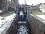
In 1832, the Feeder Canal was widened and deepened to accommodate boat traffic as well. Thirteen masonry locks were constructed to overcome the 130-foot vertical drop east of Sandy Hill (now called Hudson Falls). This engineering feat includes the "Five Combines" Locks in Hudson Falls ( at the intersection of Pine St. and Burgoye Avenue) ref name="alliance" /> The Combine Locks lower water 55 vertical feet (16.76 m). The locks are 15 feet wide (4.57m) and 100 feet long (30.48m); these dimensions controlled the size of canal boats in the Champlain Canal system while the locks were in use. The present-day Champlain Barge Canal eliminated the need for boat traffic on the Feeder Canal in the early 1900s.
as well as the Finch Pruyne & Company Paper Mill, which lies just East of the start of the Canal in Glens Falls. It is maintained by the New York State Thruway Authority.
The canal is a popular destination for canoeing and kayaking. A seven mile long park/trail along the old canal towpath is frequented by tourists and joggers and cyclists. The canal was added to the National Register of Historic Places
in 1985. The non-for profit Feeder Canal Alliance was formed in 1987 to preserve, promote and maintain the Feeder Canal.
Glens Falls, New York
Glens Falls is a city in Warren County, New York, United States. Glens Falls Metropolitan Statistical Area. The population was 14,700 at the 2010 census...
, New York
New York
New York is a state in the Northeastern region of the United States. It is the nation's third most populous state. New York is bordered by New Jersey and Pennsylvania to the south, and by Connecticut, Massachusetts and Vermont to the east...
, United States through Hudson Falls
Hudson Falls, New York
Hudson Falls is a village located in Washington County, New York, USA. The village is in the southwest part of the town of Kingsbury, on US Route 4. Hudson Falls is part of the Glens Falls Metropolitan Statistical Area. As of the 2000 census, the village had a population of 6,927...
and into Fort Edward. It is seven miles long and delivers water from above Glen's Falls on the Hudson River
Hudson River
The Hudson is a river that flows from north to south through eastern New York. The highest official source is at Lake Tear of the Clouds, on the slopes of Mount Marcy in the Adirondack Mountains. The river itself officially begins in Henderson Lake in Newcomb, New York...
to the highest point of the Champlain Canal
Champlain Canal
The Champlain Canal is a canal that connects the south end of Lake Champlain to the Hudson River in New York. It was simultaneously constructed with the Erie Canal and is now part of the New York State Canal System and the Lakes to Locks Passage....
. The Feeder Canal Heritage Trail runs along a large part of the canal.
History
The first Feeder Canal was constructed around 1822 at the foot of Fort Edward Hill, to direct water from the Hudson RiverHudson River
The Hudson is a river that flows from north to south through eastern New York. The highest official source is at Lake Tear of the Clouds, on the slopes of Mount Marcy in the Adirondack Mountains. The river itself officially begins in Henderson Lake in Newcomb, New York...
one half mile east to the Champlain Canal
Champlain Canal
The Champlain Canal is a canal that connects the south end of Lake Champlain to the Hudson River in New York. It was simultaneously constructed with the Erie Canal and is now part of the New York State Canal System and the Lakes to Locks Passage....
. When a flood destroyed part of the dam across the Hudson River at Fort Edward
Fort Edward
Fort Edward could refer to:* A historic site located in Windsor, Nova Scotia* A temporary fort in South Africa, ca. 1901. It was established in 1901 by British forces during the Boer War...
, the feeder canal failed to provide enough water.
In 1824 a new dam was built across the Hudson River upstream of Glens Falls and digging of the Glens Falls Feeder Canal began. It ran seven miles eastward to join the Champlain Canal, guaranteeing adequate water at its highest elevation.
In 1832, the Feeder Canal was widened and deepened to accommodate boat traffic as well. Thirteen masonry locks were constructed to overcome the 130-foot vertical drop east of Sandy Hill (now called Hudson Falls). This engineering feat includes the "Five Combines" Locks in Hudson Falls ( at the intersection of Pine St. and Burgoye Avenue) ref name="alliance" /> The Combine Locks lower water 55 vertical feet (16.76 m). The locks are 15 feet wide (4.57m) and 100 feet long (30.48m); these dimensions controlled the size of canal boats in the Champlain Canal system while the locks were in use. The present-day Champlain Barge Canal eliminated the need for boat traffic on the Feeder Canal in the early 1900s.
Present day
Today the canal is still an important source of water for the Champlain CanalChamplain Canal
The Champlain Canal is a canal that connects the south end of Lake Champlain to the Hudson River in New York. It was simultaneously constructed with the Erie Canal and is now part of the New York State Canal System and the Lakes to Locks Passage....
as well as the Finch Pruyne & Company Paper Mill, which lies just East of the start of the Canal in Glens Falls. It is maintained by the New York State Thruway Authority.
The canal is a popular destination for canoeing and kayaking. A seven mile long park/trail along the old canal towpath is frequented by tourists and joggers and cyclists. The canal was added to the National Register of Historic Places
National Register of Historic Places
The National Register of Historic Places is the United States government's official list of districts, sites, buildings, structures, and objects deemed worthy of preservation...
in 1985. The non-for profit Feeder Canal Alliance was formed in 1987 to preserve, promote and maintain the Feeder Canal.
External links
- Glens Falls Feeder, Sluice, Along south side of Glens Falls Feeder between locks 10 & 20, Hudson Falls, Washington, NY: 26 photos, 23 data pages, and 3 photo caption pages at Historic American Building Survey