

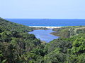
Glenrock Lagoon
Encyclopedia
Newcastle, New South Wales
The Newcastle metropolitan area is the second most populated area in the Australian state of New South Wales and includes most of the Newcastle and Lake Macquarie Local Government Areas...
, Australia
Australia
Australia , officially the Commonwealth of Australia, is a country in the Southern Hemisphere comprising the mainland of the Australian continent, the island of Tasmania, and numerous smaller islands in the Indian and Pacific Oceans. It is the world's sixth-largest country by total area...
. The catchment area is bounded by the following catchment areas, Murdering Gully to the north east, Throsby Creek, Hunter Valley
Hunter Valley
The Hunter Region, more commonly known as the Hunter Valley, is a region of New South Wales, Australia, extending from approximately to north of Sydney with an approximate population of 645,395 people. Most of the population of the Hunter Region lives within of the coast, with 55% of the entire...
to the north and north west, Winding Creek, Lake Macquarie
Lake Macquarie (New South Wales)
Lake Macquarie is Australia's largest coastal salt water lake, covering an area of in the Hunter Region of New South Wales with most of the City of Lake Macquarie's residents living near its shores. It is connected to the Tasman Sea by a short channel. Lake Macquarie is twice as large as Sydney...
to the west, Dicks Creek and Bulls Creek, Jewels Swamp to the south west and Dudley Beach to the south east.
Glenrock Lagoon came into existence 6,000 years ago when the sea level stabilised after the last ice age. The Lagoon is a small body of water approx 900 metres (2,952.8 ft) long and approx 100 m (328.1 ft) wide and covers an area of approx 80000 square metres (95,679.2 sq yd). This area does vary depending upon the water level. The water levels can vary as much as 2 m (7 ft).
While the early European pioneers gave it "Glenrock" because of the rocky nature of the Glen (a narrow valley), the area of Glenrock Lagoon was called "Pillapay-Kullaitaran" meaning "The Valley of the Palms" by the Awabakal tribe. Archaeological evidence has been found to date a campsite at Swansea Heads at 7,800 years, (Dept of Lands 1990).
History
The first coal discovered in Australia must be given to the escaped convicts William & Mary BryantMary Bryant
Mary Bryant was a Cornish convict sent to Australia. She became one of the first successful escapees from the fledgling Australian penal colony.-Life:...
on their journey to Timor. They discovered coal near the entrance to Glenrock Lagoon on 30 March 1791. They named it Fortunate Creek because they found food there and friendly Aborigines. However, the news did not get back to Sydney and it was Lieut John Shortland R. N. who received credit for the discovery of coal in Newcastle on 9 September 1797. Even today, coal can still be found in the cliff face on the northern headland at the mouth of Glenrock Lagoon.
In a letter dated 12 October 1842, to W. Kirchner of Sydney, Friedrich Wilhelm Ludwig Leichhardt
Ludwig Leichhardt
Friedrich Wilhelm Ludwig Leichhardt, known as Ludwig Leichhardt, was a Prussian explorer and naturalist, most famous for his exploration of northern and central Australia.-Early life:...
describes a walk through the valley on his way from Newcastle to Redhead via Charlestown. On this walk he described the view of the lagoon from a high vantage point. That vantage point is today known as "Leichhardt Lookout", which is on the Great North Walk
Great North Walk
The Great North Walk is a walking track which runs from Sydney to Newcastle in New South Wales, Australia. The main track, in length, runs between the Obelisk in Macquarie Place in Sydney to Queens Wharf Tower in Bicentennial Park in Newcastle and is well sign-posted. There are many "side tracks"...
.
"You'll have heard of the Valley of Palms. It happens that there are very few palms there, which makes it by so much the richer in other kinds of plants. It's a narrow, rocky gully with steep sides which widens out towards the sea. The slopes are covered with the most luxurious vegetation, trees and bushes are bound together by climbers, and the trunks of the trees are covered with parasitic plants. Floods, that have swept down with irresistible power during the heavy Winter rains, have uprooted big trees, and have produced the wildest conflagration of closely entangled life and death."
In 1883 the Burwood Coal Mining Company was formed, but it was December 1884 before a shaft was started which was completed on 10 May 1885. A private railway was built from the mine across the lagoon around the cliff face and along Burwood Beach (then known as Smelters Beach). At this time it was known as the Redhead Railway because the colliery on the lagoon was called Redhead Colliery on Glenrock Lagoon.
Flaggy Creek had been surveyed but not named as early as 1828, as shown on http://nla.gov.au/nla.map-nk646a map by Henry Dangar
Henry Dangar
Henry Dangar was a surveyor and explorer of Australia in the early period of British colonisation. He became a successful pastoralist and businessman, and also served as a magistrate and politician...
] who was a local Newcastle land owner. On that map, which is held in the National Library of Australia
National Library of Australia
The National Library of Australia is the largest reference library of Australia, responsible under the terms of the National Library Act for "maintaining and developing a national collection of library material, including a comprehensive collection of library material relating to Australia and the...
, shows the main road south through the area which will be called Charlestown, the Burwood Road ridge line called "Wahrah" and the unnamed Flaggy Creek. During the latter half of the 20th century, this creek was unofficially referred to by local families as Rocky Creek and provided a well watered bushland setting for the children of Kahibah to play.
Geography
The catchment area is approx 10 km² (4 sq mi) with a boundary of approx 11 km (7 mi), length (east to west) of 4.1 km (2.5 mi) and width varying from 0.6 km (0.372823641989884 mi) at the coast to 3.5 km (2.2 mi) in the centre. The Glenrock State Recreation Area (SRA) together with AwabakalAwabakal
Awabakal or Awabagal may refer to:*Awabakal people*Awabakal language...
Nature reserve contains 7 km² (3 sq mi) but only approx 2 km² (0.77220431718507 sq mi) (approx 30% of the catchment area) of this is within the Glenrock Lagoon catchment area.
There are 3 sub-catchments areas, Little Flaggy Creek in the north, Flaggy Creek in the centre and a small unnamed creek in the southeast. Two of the main tributaries are, Flaggy Creek (approx 4 km (2 mi) in length) and Little Flaggy Creek (also shown on some maps as Glenrock Creek). On a Map of the Parish of Kahibah dated 1887, Little Flaggy Creek was named "First Flaggy Creek" and Flaggy Creek was known as "Second Flaggy Creek".
The catchment has mainly clay soils. Dry and Swamp Sclerophyll Forest and Rainforest vegetation exists in the bush areas.
Human effects
Besides the major road corridors, there is a major walking trail, The Great North WalkGreat North Walk
The Great North Walk is a walking track which runs from Sydney to Newcastle in New South Wales, Australia. The main track, in length, runs between the Obelisk in Macquarie Place in Sydney to Queens Wharf Tower in Bicentennial Park in Newcastle and is well sign-posted. There are many "side tracks"...
(Yuelarbah Track) and The Fernleigh Track
The Fernleigh Track
The Belmont railway line is an abandoned coal haulage and passenger rail line from Adamstown, New South Wales to Belmont, New South Wales. This was a private railway, being the property of the New Redhead Estate and Coal Company and was generally known as the Belmont Branch...
Cycleway. The Great North Walk follows Flaggy Creek from Charlestown to the top of the lagoon. Then follows the northern shore of the lagoon to the beach before heading north to Newcastle along the Burwood beach past Murdering Gully and the ruins of the cooper smelter.
Also the old rail corridor to Belmont is being upgraded to a cycle way which is not due to be complete until 2015.
It is planned to be completed in 3 stages:-
Park Ave (Adamstown) to Kahibah Station Burwood Road (Kahibah) 2004
Kahibah Station Burwood Road (Kahibah) to Oakdale Road (Redhead) 2009
Oakdale Road (Redhead) to Belmont 2015.
Glenrock Lagoon has been for over a century a recreational area for the people of Newcastle and Lake Macquarie.
Within the catchment are the following suburbs - Adamstown Heights
Adamstown Heights, New South Wales
Adamstown Heights is a southern suburb of Newcastle, New South Wales, Australia, located west-southwest of Newcastle's central business district along the Pacific Highway...
, Merewether Heights, Highfields
Highfields, New South Wales
Highfields is a residential suburb of Newcastle, New South Wales, Australia, located west-southwest of Newcastle's central business district near the Charlestown town centre. It is part of the City of Lake Macquarie local government area.-External links:...
, Kahibah, Charlestown
Charlestown, New South Wales
Charlestown is a suburb of Newcastle, New South Wales, Australia, and the largest town within the City of Lake Macquarie. It is located approximately west-southwest of the central business district of Newcastle....
, Whitebridge
Whitebridge, New South Wales
Whitebridge is a suburb of Newcastle, New South Wales, Australia, located from Newcastle's central business district on the eastern side of Lake Macquarie. It is part of the City of Lake Macquarie local government area.- History :...
. However, Kahibah is the only suburb that is totally within the catchment area.