
Gilboa, New York
Encyclopedia
Gilboa is a town in Schoharie County
, New York
, United States
. The population was 1,215 at the 2000 census.
The Town of Gilboa is in the south part of the county and is southwest of Albany
.
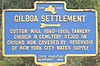
 The town was first settled around 1760.
The Town of Gilboa was formed in 1848 from regions taken from the Towns of Blenheim
and Broome
. The name "Gilboa
" is from a location in Israel.
A cotton mill in the community of Gilboa was a major contributor to the early economy of the town, but it was destroyed by a flood in 1869.
In 1926, the Schoharie Creek was dammed to form the Schoharie Reservoir. The original settlement of Gilboa was razed and flooded as part of this project. A new settlement was established north of the reservoir.
, were pronounced the oldest known trees on earth.
, the town has a total area of 59.3 square miles (153.6 km²), of which, 57.8 square miles (149.7 km²) of it is land and 1.6 square miles (4.1 km²) of it (2.63%) is water.
The south town line forms a border with Delaware County
and Greene County
.
The Schoharie Creek
flows northward through the town.
New York State Route 30
is a north-south highway in Gilboa. New York State Route 23
cuts through the southwest corner of the town. New York State Route 990V
is a highway running eastward from NY-30 in the southeast part of Gilboa.
of 2000, there were 1,215 , 478 households, and 355 families residing in the town. The population density
was 21.0 people per square mile (8.1/km²). There were 992 housing units at an average density of 17.2 per square mile (6.6/km²). The racial makeup of the town was 95.80% White, 0.91% African American, 0.25% Native American, 0.82% Asian, 1.23% from other races
, and 0.99% from two or more races. Hispanic or Latino of any race were 1.98% of the population.
There were 478 households out of which 31.0% had children under the age of 18 living with them, 60.7% were married couples
living together, 9.0% had a female householder with no husband present, and 25.7% were non-families. 20.3% of all households were made up of individuals and 9.8% had someone living alone who was 65 years of age or older. The average household size was 2.54 and the average family size was 2.92.
In the town the population was spread out with 23.2% under the age of 18, 5.6% from 18 to 24, 24.8% from 25 to 44, 29.9% from 45 to 64, and 16.5% who were 65 years of age or older. The median age was 43 years. For every 100 females there were 94.7 males. For every 100 females age 18 and over, there were 102.8 males.
The median income for a household in the town was $35,156, and the median income for a family was $38,214. Males had a median income of $31,635 versus $25,278 for females. The per capita income
for the town was $18,561. About 9.6% of families and 11.9% of the population were below the poverty line, including 11.4% of those under age 18 and 7.4% of those age 65 or over.
Schoharie County, New York
As of the census of 2000, there were 31,582 people, 11,991 households and 8,177 families residing in the county. The population density was 51 people per square mile . There were 15,915 housing units at an average density of 26 per square mile...
, New York
New York
New York is a state in the Northeastern region of the United States. It is the nation's third most populous state. New York is bordered by New Jersey and Pennsylvania to the south, and by Connecticut, Massachusetts and Vermont to the east...
, United States
United States
The United States of America is a federal constitutional republic comprising fifty states and a federal district...
. The population was 1,215 at the 2000 census.
The Town of Gilboa is in the south part of the county and is southwest of Albany
Albany, New York
Albany is the capital city of the U.S. state of New York, the seat of Albany County, and the central city of New York's Capital District. Roughly north of New York City, Albany sits on the west bank of the Hudson River, about south of its confluence with the Mohawk River...
.
History
The Town of Gilboa was formed in 1848 from regions taken from the Towns of Blenheim
Blenheim, New York
Blenheim is a town in Schoharie County, New York, United States. The population was 330 at the 2000 census. The town was named after a land patent, which itself was named after the Battle of Blenheim....
and Broome
Broome, New York
----Broome is a town in Schoharie County, New York, United States. The population was 947 at the 2000 census. The town is named after John Broome.The Town of Broome is on the eastern border of the county, southwest of Albany.- History :...
. The name "Gilboa
Gilboa
Gilboa is a Hebrew word and the name of several places:*Mount Gilboa, a biblical locale in Israel, where king saul's sons were killed by the philistines, and saul took his own life...
" is from a location in Israel.
A cotton mill in the community of Gilboa was a major contributor to the early economy of the town, but it was destroyed by a flood in 1869.
In 1926, the Schoharie Creek was dammed to form the Schoharie Reservoir. The original settlement of Gilboa was razed and flooded as part of this project. A new settlement was established north of the reservoir.
Fossil Forest
In 1870, workers blasting a site for a stone quarry found fossilized remains of tree stumps. In 2004, the tops and fronds of the trees were discovered and, in 2007, the fern-like trees, named WattiezaWattieza
Wattieza was a genus of prehistoric trees that existed in the mid-Devonian that belong to the cladoxylopsids, close relatives of the modern ferns and horsetails...
, were pronounced the oldest known trees on earth.
Geography
According to the United States Census BureauUnited States Census Bureau
The United States Census Bureau is the government agency that is responsible for the United States Census. It also gathers other national demographic and economic data...
, the town has a total area of 59.3 square miles (153.6 km²), of which, 57.8 square miles (149.7 km²) of it is land and 1.6 square miles (4.1 km²) of it (2.63%) is water.
The south town line forms a border with Delaware County
Delaware County, New York
Delaware County is a county located in the U.S. state of New York. As of 2010 the population was 47,980. The county seat is Delhi. It is named after the Delaware River, which was named in honor of Thomas West, 3rd Baron De La Warr, appointed governor of Virginia in 1609.-History:When counties...
and Greene County
Greene County, New York
Greene County is a county located in the U.S. state of New York. Its name is in honor of the American Revolutionary War general Nathanael Greene. Its county seat is Catskill...
.
The Schoharie Creek
Schoharie Creek
Schoharie Creek in New York, USA flows north from the foot of Indian Head Mountain in the Catskill Mountains through the Schoharie Valley to the Mohawk River. It is twice impounded north of Prattsville to create New York City's Schoharie Reservoir and the Blenheim-Gilboa Power Project.Two notable...
flows northward through the town.
New York State Route 30
New York State Route 30
New York State Route 30 is a state highway in the central part of New York in the United States. It extends for from an interchange with NY 17 in the Southern Tier to the Canadian border in the state's North Country, where it continues into Quebec as Route 138. On a regional level,...
is a north-south highway in Gilboa. New York State Route 23
New York State Route 23
New York State Route 23 is an east–west state highway in the eastern portion New York in the United States. It extends for from an intersection with NY 26 in the Central New York town of Cincinnatus to the Massachusetts state line in the Berkshire Mountains, where it continues east as...
cuts through the southwest corner of the town. New York State Route 990V
New York State Route 990V
New York State Route 990V is a long east–west reference route in Schoharie County, New York, United States. The western terminus of the route is at an intersection with NY 30 in Gilboa. Its eastern terminus is at County Route 18 in Conesville, where the road continues east as...
is a highway running eastward from NY-30 in the southeast part of Gilboa.
Demographics
As of the censusCensus
A census is the procedure of systematically acquiring and recording information about the members of a given population. It is a regularly occurring and official count of a particular population. The term is used mostly in connection with national population and housing censuses; other common...
of 2000, there were 1,215 , 478 households, and 355 families residing in the town. The population density
Population density
Population density is a measurement of population per unit area or unit volume. It is frequently applied to living organisms, and particularly to humans...
was 21.0 people per square mile (8.1/km²). There were 992 housing units at an average density of 17.2 per square mile (6.6/km²). The racial makeup of the town was 95.80% White, 0.91% African American, 0.25% Native American, 0.82% Asian, 1.23% from other races
Race (United States Census)
Race and ethnicity in the United States Census, as defined by the Federal Office of Management and Budget and the United States Census Bureau, are self-identification data items in which residents choose the race or races with which they most closely identify, and indicate whether or not they are...
, and 0.99% from two or more races. Hispanic or Latino of any race were 1.98% of the population.
There were 478 households out of which 31.0% had children under the age of 18 living with them, 60.7% were married couples
Marriage
Marriage is a social union or legal contract between people that creates kinship. It is an institution in which interpersonal relationships, usually intimate and sexual, are acknowledged in a variety of ways, depending on the culture or subculture in which it is found...
living together, 9.0% had a female householder with no husband present, and 25.7% were non-families. 20.3% of all households were made up of individuals and 9.8% had someone living alone who was 65 years of age or older. The average household size was 2.54 and the average family size was 2.92.
In the town the population was spread out with 23.2% under the age of 18, 5.6% from 18 to 24, 24.8% from 25 to 44, 29.9% from 45 to 64, and 16.5% who were 65 years of age or older. The median age was 43 years. For every 100 females there were 94.7 males. For every 100 females age 18 and over, there were 102.8 males.
The median income for a household in the town was $35,156, and the median income for a family was $38,214. Males had a median income of $31,635 versus $25,278 for females. The per capita income
Per capita income
Per capita income or income per person is a measure of mean income within an economic aggregate, such as a country or city. It is calculated by taking a measure of all sources of income in the aggregate and dividing it by the total population...
for the town was $18,561. About 9.6% of families and 11.9% of the population were below the poverty line, including 11.4% of those under age 18 and 7.4% of those age 65 or over.
Communities and locations in Gilboa
- Blenheim-Gilboa Reservoir – A reservoir partly in the northwest part of Gilboa.
- Broome Center – A hamlet in the northeastern part of the town located on County Road 17, settled around 1850.
- Five Corners – A location south of Mackey at the junction of County Roads 17 and 18.
- Flat Creek – A hamlet in the eastern part of the town on County Road 17.
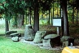
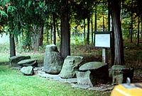
- Gilboa – The hamlet of Gilboa is north of the Gilboa Reservoir.
- Gilboa-Conesville Central SchoolGilboa-Conesville Central SchoolThe Gilboa-Conesville Central School District is a small, rural school located in the Northern Catskill Mountains. There are about 375 students in grades K–12 housed in one building in Gilboa, Schoharie County New York....
– The only school in Gilboa. - Mackey – A hamlet west of Broome Center.
- Mayham Pond – A small lake north of South Gilboa Station.
- Owlsville – A hamlet in the northeast part of the town.
- Schoharie ReservoirSchoharie ReservoirThe Schoharie Reservoir is a small reservoir in the Catskill Mountains of New York State that was created to be one of 19 reservoirs that supplies New York City with water. It was created by impounding Schoharie Creek...
– A reservoir partly in the southeast corner of the town, south of Gilboa village. - South Gilboa – A hamlet in the southwest part of Gilboa on County Road 14.
- South Gilboa Station – A location in the southwestern part of the town on NY-23.
- Upper Blenheim-Gilboa Reservoir – A reservoir in the northwest part of Gilboa, east of the Blenheim-Gilboa Reservoir.
- Welch Corners – A location in the northwest part of the town.