

Giambattista Nolli
Encyclopedia
Architect
An architect is a person trained in the planning, design and oversight of the construction of buildings. To practice architecture means to offer or render services in connection with the design and construction of a building, or group of buildings and the space within the site surrounding the...
and Surveyor
Surveying
See Also: Public Land Survey SystemSurveying or land surveying is the technique, profession, and science of accurately determining the terrestrial or three-dimensional position of points and the distances and angles between them...
.
Born in Como
Como
Como is a city and comune in Lombardy, Italy.It is the administrative capital of the Province of Como....
, he moved to Rome
Rome
Rome is the capital of Italy and the country's largest and most populated city and comune, with over 2.7 million residents in . The city is located in the central-western portion of the Italian Peninsula, on the Tiber River within the Lazio region of Italy.Rome's history spans two and a half...
thanks to the patronage of members of the patrician Albani
Albani
Albani is an Italian surname from Latin name Albanus or from Alba , a frequent toponym in Italy...
and Corsini
Corsini
Corsini is the name of a Florentine princely family.-History:The founder is said to be Neri Corsini, who came to prominence circa 1170. The family are likely to have originated from Corsica, during the time when the Republic of Pisa was ruling the island. Initially the family was known as Corso ...
families. He is best known for his ichnographic
Ichnography
Ichnography , pronounced ik-nog-rəfi, in architecture, is a term defined by Vitruvius as the ground plan of the work, i.e...
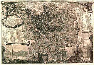
plan of Rome, the Pianta Grande di Roma which he began surveying in 1736 and engraved in 1748, and now universally known as the Nolli Map. The map is composed of 12 copper plate engravings that together measures 176x208 cms and was published in response to the commission of Pope Benedict XIV
Pope Benedict XIV
Pope Benedict XIV , born Prospero Lorenzo Lambertini, was Pope from 17 August 1740 to 3 May 1758.-Life:...
to survey Rome in order to help create demarcations for the 14 traditional rioni or districts.It was by far the most accurate description of Rome produced to date at a time when the architectural achievement of the Papacy was in full flower.
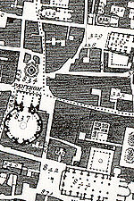
The Nolli map reflects Bufalini's map of 1551, with which Nolli readily invited comparison, however Nolli made a number of important innovations. Firstly, Nolli reorients the city from east (which was conventional at the time) to magnetic north, reflecting Nolli's reliance on the compass to get a bearing on the city's topography. Secondly, though he follows Bufalini in using a figure-ground representation
Figure-ground diagram
A figure-ground diagram is a two-dimensional map of an urban space that shows the relationship between built and unbuilt space. It is used in analysis of urban design and planning...
of built space with blocks and building shaded in a dark poché, Nolli represents enclosed public spaces such as the colonnades in St. Peter's Square and the Pantheon
Pantheon, Rome
The Pantheon ,Rarely Pantheum. This appears in Pliny's Natural History in describing this edifice: Agrippae Pantheum decoravit Diogenes Atheniensis; in columnis templi eius Caryatides probantur inter pauca operum, sicut in fastigio posita signa, sed propter altitudinem loci minus celebrata.from ,...
as open civic spaces. Finally, the map was a significant improvement in accuracy, even noting the asymmetry of the Spanish Steps
Spanish Steps
The Spanish Steps are a set of steps in Rome, Italy, climbing a steep slope between the Piazza di Spagna at the base and Piazza Trinità dei Monti, dominated by the Trinità dei Monti church at the top. The Scalinata is the widest staircase in Europe...
. The map was used in government planning for the city of Rome until the 1970s;it was used as a base map for all Roman mapping and planning up to that date.
The map is framed with a vedute by Stefano Pozzi
Stefano Pozzi
Stefano Pozzi was an Italian painter, designer, draughtsman and decorator whose career was spent largely in Rome....
. A scaled-down edition, a collaboration between Nolli and Giovanni Battista Piranesi
Giovanni Battista Piranesi
Giovanni Battista Piranesi was an Italian artist famous for his etchings of Rome and of fictitious and atmospheric "prisons" .-His Life:...
, was published in the same year the original map was finished. Piranesi was instrumental in getting the work printed; Giuseppe Vasi
Giuseppe Vasi
Giuseppe Vasi was an Italian engraver and architect, best known for his vedute.He was born in Corleone, Sicily and later moved to Rome. From 1746 to 1761 he published a series of ten volumes including 240 engravings of vedute of Rome...
also contributed.
As an architect, he worked on the churches of San Dorotea in Trastevere
Trastevere
Trastevere is rione XIII of Rome, on the west bank of the Tiber, south of Vatican City. Its name comes from the Latin trans Tiberim, meaning literally "beyond the Tiber". The correct pronunciation is "tras-TEH-ve-ray", with the accent on the second syllable. Its logo is a golden head of a lion on a...
(1751–1756) and Sant'Alessio
Sant'Alessio
Sant'Alessio is an opera in three acts composed by Stefano Landi in 1631 with a libretto by Giulio Rospigliosi.Sant'Alessio was the first opera to be written on a historical subject. It describes the inner life of fifth-century Saint Alexis. The work broke new ground with a psychological...
on the Aventine Hill
Aventine Hill
The Aventine Hill is one of the seven hills on which ancient Rome was built. It belongs to Ripa, the twelfth rione, or ward, of Rome.-Location and boundaries:The Aventine hill is the southernmost of Rome's seven hills...
(1743).
Nolli Map
Nolly map is a map to measure the density of cities mainly in black and white. Nolly map was invented in 1748 when Italian architect Giambattista Nolli drew the map of Rome for Pope Benedict the 14th. Nolly was one of the first people who used orthogonal rotation representation map of the city, compared with conventional representations at the time of the bird's eye view. Accurate map and compare it to air photography.One of the things on the map is the form Nolly choose to represent the area of the city. While buildings are shown in black, as white displays looms all the city's public space
Public space
A public space is a social space such as a town square that is open and accessible to all, regardless of gender, race, ethnicity, age or socio-economic level. One of the earliest examples of public spaces are commons. For example, no fees or paid tickets are required for entry, nor are the entrants...
, it also includes the inner space of the churches and the monasteries and palaces and courtyards. This representation method has become widely accepted urban design, as a way to show the public space. Result from the way this representation of beauty can be great shade of public space in Rome, and that every corner of it is "positive. " Wherever you are, you're part of a convex space that surrounds you like a room. Another interesting feature is to combine that built the open space as defined. Buildings define the open space, open space and the buildings. Compared with the most common method today is floating in buildings without reference to him.
External links
- Interactive Nolli Map Website from the University of Oregon.
- 'The Nolli Plan of Rome: Facsimile', Full-size facsimile portfolio; introductory essay, "Portrait of a City," by Allen Ceen, published by J.H. Aronson, Highmount, NY, USA. First ed., 1984, 2nd ed., 1991.
- 'The Nolli Plan of Rome: Poster', Half-size poster based on facsimile portfolio, published by J.H. Aronson, Highmount, NY, USA, 1984.